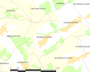
Берензвиллер (Berentzwiller, Berentzwiller)

- коммуна во Франции
 Hiking in Берензвиллер
Berentzwiller is a small village located in the Alsace region of France, near the border with Switzerland. While it might not be as widely known as some larger hiking destinations, the surrounding area offers some beautiful trails and a chance to explore the picturesque landscape of Alsace.
Hiking in and around Berentzwiller:
-
Scenic Trails: The area around Berentzwiller features a mix of forested paths and open fields, providing hikers with lovely views of the Vosges Mountains and the Jura mountain range in the distance.
-
Local Nature: Hikers can expect to encounter diverse flora and fauna. The surrounding hillsides and forests are popular for birdwatching and may host seasonal wildlife.
-
Cultural Insights: Hiking in this area can also be an opportunity to experience traditional Alsatian culture, including vineyards and charming villages along the way. The Alsace wine route is not far and can be integrated into a longer hike.
-
Trail Options: While there may not be extensive marked trails directly in Berentzwiller, several paths connect to larger networks in the region, such as the GR5 long-distance trail, which runs through Alsace and offers various hiking lengths and levels of difficulty.
-
Accessibility: Berentzwiller is conveniently located for those who want to explore the nearby cities of Mulhouse and Basel, making it possible to enjoy a day hike and return to urban amenities easily.
Tips for Hiking in Berentzwiller:
- Local Weather: Check weather conditions before you head out, as they can change rapidly in the region.
- Gear: Wear suitable hiking shoes and carry a map or a GPS device. It’s also wise to bring water and snacks, especially on longer hikes.
- Respect Nature: Due to its natural beauty, it’s essential to follow Leave No Trace principles to preserve the environment.
Suggested Routes:
- You might consider combining a hike with a visit to nearby landmarks or natural wonders. Research specific trails that lead to viewpoints or historical sites for a more enriching experience.
While Berentzwiller may not have the most famous trails, the tranquility and beauty of the Alsace countryside make it a lovely spot for a day of hiking. Enjoy your adventure!
- Страна:

- Почтовый код: 68130
- Координаты: 47° 35' 9" N, 7° 23' 1" E


- GPS треки (wikiloc): [Ссылка]
- Площадь: 6.08 кв.км
- Население: 322
- Википедия русская: wiki(ru)
- Википедия английская: wiki(en)
- Википедия национальная: wiki(fr)
- Хранилище Wikidata: Wikidata: Q325297
- Катеория в википедии: [Ссылка]
- код Freebase: [/m/03ns301]
- код Freebase: [/m/03ns301]
- код GeoNames: Альт: [6450652]
- код GeoNames: Альт: [6450652]
- номер SIREN: [216800276]
- номер SIREN: [216800276]
- код BNF: [152717313]
- код BNF: [152717313]
- код муниципалитета INSEE: 68027
- код муниципалитета INSEE: 68027
Граничит с регионами:


Кнёренг
- коммуна во Франции
Hiking in Кнёренг
Knœringue is a picturesque village located in the Alsace region of France, near the border with Germany and Switzerland. It serves as a launching point for various hiking opportunities in the surrounding areas, particularly in the Vosges mountains and the Jura region....
- Страна:
- Почтовый код: 68220
- Координаты: 47° 33' 49" N, 7° 24' 10" E
- GPS треки (wikiloc): [Ссылка]
- Площадь: 4.68 кв.км
- Население: 381

Ранспак-ле-О
- коммуна во Франции
Hiking in Ранспак-ле-О
Ranspach-le-Haut, located in the Haut-Rhin department of France, offers a scenic environment for hiking enthusiasts. Nestled near the borders of Switzerland and Germany, this charming village is surrounded by lush forests, rolling hills, and beautiful landscapes that provide an array of hiking opportunities....
- Страна:
- Почтовый код: 68220
- Координаты: 47° 34' 40" N, 7° 25' 15" E
- GPS треки (wikiloc): [Ссылка]
- Площадь: 4.39 кв.км
- Население: 621

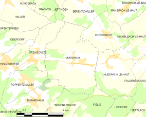
Мюспак
- коммуна во Франции
Hiking in Мюспак
Muespach is a charming village located in the Alsace region of France, close to the border with Switzerland. This picturesque area offers several hiking opportunities for various skill levels, and the surrounding nature is known for its stunning landscapes, lush forests, and rolling hills....
- Страна:
- Почтовый код: 68640
- Координаты: 47° 32' 51" N, 7° 22' 50" E
- GPS треки (wikiloc): [Ссылка]
- Высота над уровнем моря: 400 м m
- Площадь: 11.37 кв.км
- Население: 873
- Веб сайт: [Ссылка]

Эльфранзкирш
- коммуна во Франции
Hiking in Эльфранзкирш
Helfrantzkirch, located in Germany, is not a widely recognized hiking destination, but it could serve as a tranquil spot for outdoor enthusiasts interested in exploring the natural scenery of the region. The surrounding areas might offer various trails suited for different skill levels, from easy walks to more challenging hikes....
- Страна:
- Почтовый код: 68510
- Координаты: 47° 36' 27" N, 7° 24' 58" E
- GPS треки (wikiloc): [Ссылка]
- Площадь: 6.23 кв.км
- Население: 706


Стенсульц
- коммуна во Франции
Hiking in Стенсульц
Steinsoultz, located in the Alsace region of France near the Vosges mountains, offers a picturesque setting for hiking enthusiasts. The region is known for its stunning landscapes, charming villages, and diverse trails that cater to various skill levels....
- Страна:
- Почтовый код: 68640
- Координаты: 47° 33' 14" N, 7° 20' 15" E
- GPS треки (wikiloc): [Ссылка]
- Площадь: 4.06 кв.км
- Население: 788


Жеттинген
- коммуна во Франции
Hiking in Жеттинген
Jettingen, located in the Haut-Rhin department of the Grand Est region of France, offers a beautiful setting for hiking, nestled among picturesque landscapes and the natural beauty of the Alsace region. Here are some points of interest and information for hiking in and around Jettingen:...
- Страна:
- Почтовый код: 68130
- Координаты: 47° 35' 52" N, 7° 22' 17" E
- GPS треки (wikiloc): [Ссылка]
- Площадь: 6.3 кв.км
- Население: 511