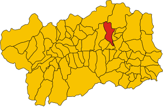
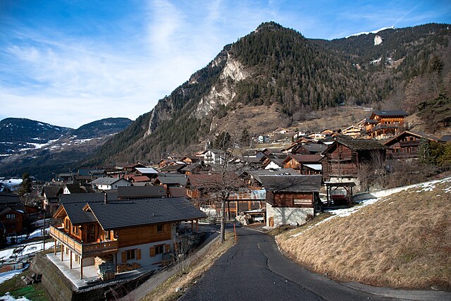
Бьона (Bionaz, Bionaz)
.svg)
- коммуна Италии
 Hiking in Бьона
Bionaz is a picturesque valley located in the Aosta Valley region of Italy, offering stunning landscapes, charming scenery, and a variety of hiking opportunities. Here’s what you need to know about hiking in Bionaz:
Key Hiking Trails
-
Lago di Place Moulin:
- Distance: Approximately 10 km round trip.
- Difficulty: Moderate.
- Description: This hike takes you to the beautiful Place Moulin Lake. The trail offers stunning views of the surrounding mountains and valleys. The area is a great spot for picnicking while enjoying the serene alpine environment.
-
Rifugio Coda:
- Distance: About 12 km round trip.
- Difficulty: Moderate to difficult.
- Description: This trail leads to the Coda refuge, providing breathtaking views of the Gran Paradiso National Park. It’s a wonderful choice for those looking to experience the local wildlife and flora.
-
Val di Bionaz:
- Distance: Varies based on chosen routes.
- Difficulty: Easy to moderate.
- Description: The valley offers various paths suitable for all skill levels. You can choose shorter walks or longer treks, all of which offer stunning alpine scenery and the chance to explore the local culture.
Best Time to Hike
- Summer (June to September): This is the best time for hiking, with trails fully accessible, wildflowers in bloom, and pleasant weather.
- Autumn: Enjoy the fall foliage, but check for trail conditions as they can vary with weather changes.
Preparation Tips
- Gear: Wear sturdy hiking boots, and consider using trekking poles for easier navigation in certain areas.
- Supplies: Bring plenty of water, snacks, and a map or GPS device. Cell service may be limited in remote areas.
- Weather: Always check the weather before heading out, as conditions can change rapidly in the mountains.
Local Attractions
Bionaz is not only about hiking; you can also explore local culture, enjoy traditional cuisine, and visit historical sites. Consider taking the time to experience the local hospitality and enjoy outdoor activities like fishing and cycling.
Hiking in Bionaz offers a chance to enjoy both natural beauty and a serene environment, making it a fantastic destination for outdoor enthusiasts. Always remember to leave no trace and respect the natural surroundings!
- Страна:

- Почтовый код: 11010
- Телефонный код: 0165
- Код автомобильного номера: AO
- Координаты: 45° 52' 0" N, 7° 25' 0" E


- GPS треки (wikiloc): [Ссылка]
- Высота над уровнем моря: 1606 м m
- Площадь: 142.09 кв.км
- Население: 235
- Веб сайт: http://www.comune.bionaz.ao.it
- Википедия русская: wiki(ru)
- Википедия английская: wiki(en)
- Википедия национальная: wiki(it)
- Хранилище Wikidata: Wikidata: Q34858
- Катеория в википедии: [Ссылка]
- Карты в википедии: [Ссылка]
- код Freebase: [/m/0fs_24]
- код GeoNames: Альт: [6536456]
- ID отношения в OpenStreetMap: [46400]
- код ISTAT: 007010
- кадастровый код Италии: A877
Граничит с регионами:


Церматт
Hiking in Церматт
Zermatt, located in the Swiss Alps, is a stunning destination for hiking enthusiasts. This charming car-free village, nestled at the foot of the iconic Matterhorn, offers a range of hiking trails for all skill levels, providing breathtaking views and a chance to explore the unique Alpine landscape....
- Страна:

- Почтовый код: 3920
- Телефонный код: 027
- Код автомобильного номера: VS
- Координаты: 45° 59' 23" N, 7° 45' 10" E
- GPS треки (wikiloc): [Ссылка]
- Высота над уровнем моря: 2621 м m
- Площадь: 242.67 кв.км
- Население: 5643
- Веб сайт: [Ссылка]


Нюс
- коммуна Италии
Hiking in Нюс
Nus, a charming village located in the Aosta Valley region of Italy, offers some wonderful hiking opportunities. The picturesque landscape is characterized by mountains, valleys, and lush greenery, making it a great destination for outdoor enthusiasts. Here are some key points about hiking in Nus:...
- Страна:
- Почтовый код: 11020
- Телефонный код: 0165
- Код автомобильного номера: AO
- Координаты: 45° 44' 0" N, 7° 28' 0" E
- GPS треки (wikiloc): [Ссылка]
- Высота над уровнем моря: 529 м m
- Площадь: 57.36 кв.км
- Население: 2991
- Веб сайт: [Ссылка]


Оломон
- коммуна Италии
Hiking in Оломон
Ollomont is a charming municipality located in the Aosta Valley region of Italy, known for its stunning natural landscapes and outdoor recreational opportunities, including hiking. Here are some insights into hiking in Ollomont:...
- Страна:
- Почтовый код: 11010
- Телефонный код: 0165
- Код автомобильного номера: AO
- Координаты: 45° 51' 0" N, 7° 19' 0" E
- GPS треки (wikiloc): [Ссылка]
- Высота над уровнем моря: 1356 м m
- Площадь: 53.48 кв.км
- Население: 157
- Веб сайт: [Ссылка]


Ойас
- коммуна Италии
Hiking in Ойас
Oyace is a picturesque village located in the Aosta Valley region of Italy, surrounded by stunning alpine scenery. It offers various hiking opportunities for outdoor enthusiasts. Here’s an overview of what you can expect when hiking in and around Oyace:...
- Страна:
- Почтовый код: 11010
- Телефонный код: 0165
- Код автомобильного номера: AO
- Координаты: 45° 51' 0" N, 7° 23' 0" E
- GPS треки (wikiloc): [Ссылка]
- Высота над уровнем моря: 1377 м m
- Площадь: 30.56 кв.км
- Население: 211
- Веб сайт: [Ссылка]

Торньон
- коммуна Италии
Hiking in Торньон
Torgnon is a beautiful village located in the Aosta Valley region of Italy, nestled in the Italian Alps. It's known for its stunning landscapes, lush valleys, and pristine nature, making it an ideal destination for hiking enthusiasts. Here are some key points about hiking in Torgnon:...
- Страна:
- Почтовый код: 11020
- Телефонный код: 0166
- Код автомобильного номера: AO
- Координаты: 45° 48' 0" N, 7° 34' 0" E
- GPS треки (wikiloc): [Ссылка]
- Высота над уровнем моря: 1489 м m
- Площадь: 42.46 кв.км
- Население: 587
- Веб сайт: [Ссылка]


Вальтурнанш
- коммуна Италии
Hiking in Вальтурнанш
Valtournenche, located in the Aosta Valley of Italy near the Swiss border, is a stunning destination for hiking enthusiasts. It's well-known for its breathtaking mountain scenery, including views of the iconic Matterhorn, which is particularly visible from the valley and its surrounding areas. Here are some highlights about hiking in Valtournenche:...
- Страна:
- Почтовый код: 11028
- Телефонный код: 0166
- Код автомобильного номера: AO
- Координаты: 45° 53' 0" N, 7° 37' 0" E
- GPS треки (wikiloc): [Ссылка]
- Высота над уровнем моря: 1528 м m
- Площадь: 116.15 кв.км
- Население: 2294
- Веб сайт: [Ссылка]

Bagnes
Hiking in Bagnes
Bagnes, located in the Valais region of Switzerland, is a spectacular destination for hikers, offering a variety of trails that cater to different skill levels. The region is known for its stunning alpine scenery, including dramatic mountain peaks, lush valleys, and picturesque villages....
- Страна:
- Почтовый код: 1934
- Телефонный код: 027
- Код автомобильного номера: VS
- Координаты: 46° 5' 0" N, 7° 13' 0" E
- GPS треки (wikiloc): [Ссылка]
- Высота над уровнем моря: 924 м m
- Площадь: 282.2 кв.км
- Население: 8100
- Веб сайт: [Ссылка]


Эволен
- комунна в Швейцарии
Hiking in Эволен
Evolène is a picturesque village located in the Val d'Hérens region of the Swiss Alps, known for its stunning natural landscapes, traditional architecture, and rich cultural heritage. This area offers a variety of hiking trails that cater to different experience levels and preferences....
- Страна:
- Почтовый код: 1983
- Телефонный код: 027
- Код автомобильного номера: VS
- Координаты: 46° 6' 46" N, 7° 29' 46" E
- GPS треки (wikiloc): [Ссылка]
- Высота над уровнем моря: 2602 м m
- Площадь: 209.94 кв.км
- Население: 1701
- Веб сайт: [Ссылка]