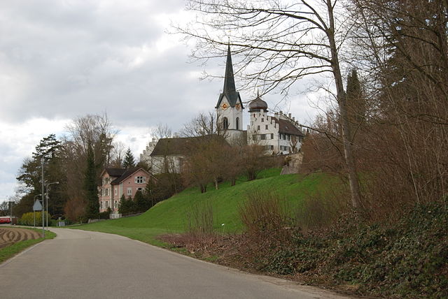
Бирвинкен (Birwinken, Birwinken)

 Hiking in Бирвинкен
Birwinken is a charming area in Switzerland that offers a variety of hiking opportunities. Nestled in the scenic landscapes, it is an excellent place for outdoor enthusiasts to explore nature. Here are some highlights and tips for hiking in Birwinken:
Trails
-
Lake Constance Trail: Close to Birwinken, this scenic route offers stunning views of Lake Constance and the surrounding hills. It’s relatively flat, making it accessible for all levels of hikers.
-
Alp Fähl Trail: This more challenging trail takes you through forests and offers breathtaking views of the Swiss Alps. It's perfect for experienced hikers looking to immerse themselves in nature.
-
Wine Trail: Explore the vineyards surrounding Birwinken, where you can enjoy both hiking and wine tasting. The routes vary in difficulty and offer a lovely mix of culture and nature.
Safety Tips
- Weather: Check the weather conditions before heading out, as they can change rapidly in the mountains.
- Gear: Wear appropriate footwear and bring layers, sunscreen, and enough water and snacks for the hike.
- Maps: Use a detailed hiking map or an app to stay oriented, as some trails can be less marked.
Best Times to Hike
- Season: Late spring through early fall is typically the best time to hike in this area, with lush greenery and pleasant temperatures.
- Time of Day: Early mornings or late afternoons can offer cooler temperatures and fewer crowds.
Local Amenities
Birwinken has local accommodations, eateries, and potentially guided hiking services that might enhance your experience. Don’t hesitate to interact with locals for recommendations on trails and hidden gems!
Conclusion
Hiking in Birwinken can be a rewarding experience whether you are a novice or an expert. The combination of beautiful landscapes, varied trails, and local culture makes it an exceptional destination for nature lovers. Always be prepared and enjoy your adventure!
- Страна:

- Почтовый код: 8585
- Телефонный код: 071
- Код автомобильного номера: TG
- Координаты: 47° 35' 0" N, 9° 12' 0" E


- GPS треки (wikiloc): [Ссылка]
- Высота над уровнем моря: 550 м m
- Площадь: 12.3 кв.км
- Население: 1352
- Веб сайт: http://www.birwinken.ch
- Википедия русская: wiki(ru)
- Википедия английская: wiki(en)
- Википедия национальная: wiki(de)
- Хранилище Wikidata: Wikidata: Q65767
- Катеория в википедии: [Ссылка]
- код Freebase: [/m/0g2gmc]
- код GeoNames: Альт: [7285260]
- код VIAF: Альт: [243168652]
- ID отношения в OpenStreetMap: [1684506]
- идентификатор HDS: [2003]
- код швейцарского муниципалитета: [4901]
Граничит с регионами:

Эрлен
Hiking in Эрлен
Erlen is a small municipality in the canton of Thurgau, Switzerland, known for its picturesque landscapes and access to various outdoor activities, including hiking. While Erlen itself may not be a major hiking destination, it is well-positioned for enjoying the surrounding natural beauty....
- Страна:
- Почтовый код: 8586
- Телефонный код: 071
- Код автомобильного номера: TG
- Координаты: 47° 33' 4" N, 9° 14' 10" E
- GPS треки (wikiloc): [Ссылка]
- Высота над уровнем моря: 445 м m
- Площадь: 12.2 кв.км
- Население: 3687
- Веб сайт: [Ссылка]
Бюрглен
Hiking in Бюрглен
Bürglen is a charming village located in the Thurgau canton of Switzerland, known for its picturesque landscapes and scenic views. Hiking in this area offers a wonderful opportunity to experience the natural beauty of the region, including rolling hills, vineyards, and lush forests....
- Страна:
- Почтовый код: 8575
- Телефонный код: 071
- Код автомобильного номера: TG
- Координаты: 47° 32' 59" N, 9° 8' 59" E
- GPS треки (wikiloc): [Ссылка]
- Высота над уровнем моря: 441 м m
- Площадь: 11.7 кв.км
- Население: 3788
- Веб сайт: [Ссылка]

Зульген
Hiking in Зульген
Sulgen is a charming village located in the canton of Thurgau, Switzerland. While it may not be as famous as some other hiking destinations in Switzerland, it does offer some beautiful trails and scenic landscapes that are perfect for hiking enthusiasts....
- Страна:
- Почтовый код: 8583
- Телефонный код: 071
- Код автомобильного номера: TG
- Координаты: 47° 32' 32" N, 9° 11' 35" E
- GPS треки (wikiloc): [Ссылка]
- Высота над уровнем моря: 486 м m
- Площадь: 9.1 кв.км
- Население: 3766
- Веб сайт: [Ссылка]
Ленгвиль
Hiking in Ленгвиль
Lengwil is a charming village located in Switzerland, nestled near Lake Constance and not far from the borders of Germany and Austria. While it's not one of the most widely recognized hiking destinations, it does offer access to beautiful landscapes and trails suitable for various skill levels. Here are some key points about hiking in and around Lengwil:...
- Страна:
- Почтовый код: 8574
- Телефонный код: 071
- Код автомобильного номера: TG
- Координаты: 47° 36' 59" N, 9° 10' 59" E
- GPS треки (wikiloc): [Ссылка]
- Высота над уровнем моря: 470 м m
- Площадь: 8.8 кв.км
- Население: 1718
- Веб сайт: [Ссылка]


Лангриккенбах
Hiking in Лангриккенбах
Langrickenbach is a picturesque village located in the region of Thurgau in Switzerland. It's surrounded by beautiful landscapes, making it a great destination for hiking enthusiasts. The area offers a variety of trails that cater to different skill levels, from easy walks suitable for families to more challenging routes for experienced hikers....
- Страна:
- Почтовый код: 8585
- Телефонный код: 071
- Код автомобильного номера: TG
- Координаты: 47° 35' 41" N, 9° 14' 27" E
- GPS треки (wikiloc): [Ссылка]
- Высота над уровнем моря: 534 м m
- Площадь: 10.9 кв.км
- Население: 1313
- Веб сайт: [Ссылка]

Берг
- коммуна в Швейцарии, в кантоне Тургау
Hiking in Берг
Berg, located in the Thurgau region of Switzerland, is a charming area that offers a variety of hiking opportunities amid picturesque landscapes. The region is known for its rolling hills, vineyards, and views over Lake Constance. Here are some key aspects to consider:...
- Страна:
- Почтовый код: 8572
- Телефонный код: 071
- Код автомобильного номера: TG
- Координаты: 47° 33' 59" N, 9° 9' 59" E
- GPS треки (wikiloc): [Ссылка]
- Высота над уровнем моря: 540 м m
- Площадь: 13.1 кв.км
- Население: 3328
- Веб сайт: [Ссылка]