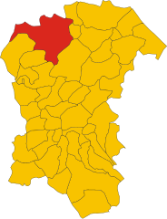
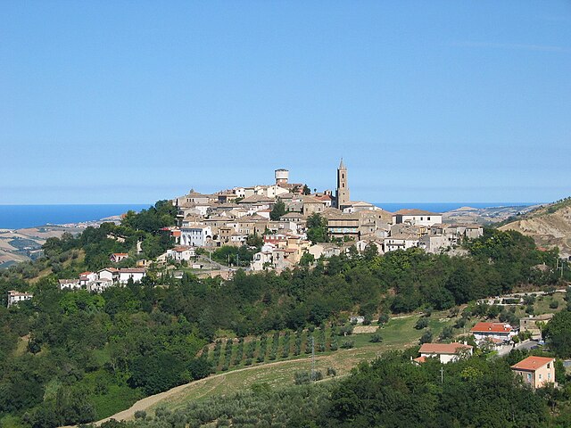
Бизенти (Bisenti, Bisenti)
.svg)
- коммуна Италии
 Hiking in Бизенти
Bisenti is a charming town located in the Abruzzo region of Italy, surrounded by beautiful landscapes that are perfect for hiking enthusiasts. The area offers a mix of natural beauty, historical sites, and local culture, making it an excellent destination for hikers of all levels. Here are some highlights of hiking in and around Bisenti:
-
Scenic Trails: The region features a variety of hiking trails that range from easy walks to more challenging treks. One popular option is exploring the nearby Gran Sasso e Monti della Laga National Park, which is known for its stunning mountain views and diverse wildlife.
-
Cultural Sites: While hiking, you may come across historical landmarks such as ancient churches, ruins, and medieval villages. Take time to explore these sites, as they add cultural depth to your hiking experience.
-
Local Flora and Fauna: The area around Bisenti is rich in biodiversity. Hikers can enjoy spotting various plant species and local wildlife. Look out for birds, deer, and other animals that inhabit the region.
-
Wine and Cuisine: After a day of hiking, treat yourself to the local cuisine and wines. The Abruzzo region is famous for its hearty dishes and exquisite wines, which can be enjoyed in the town's restaurants and trattorias.
-
Seasonal Hiking: Each season offers a different hiking experience. Spring and summer boast lush greenery and blooming flowers, while autumn brings beautiful foliage. Winter hikes can also be rewarding in the snow-covered landscapes.
-
Safety and Preparation: As with any hiking trip, it's important to be prepared. Ensure you have the proper gear, carry enough water and snacks, and check local weather conditions before heading out.
-
Guided Tours: If you're not familiar with the area, consider joining a guided hiking tour. Local guides can provide insights about the trails and the natural and cultural history of Bisenti and its surroundings.
Overall, hiking in Bisenti offers a perfect blend of nature and culture. Whether you are after strenuous mountain hikes or leisurely walks through picturesque landscapes, this region has something for everyone.
- Страна:

- Почтовый код: 64033
- Телефонный код: 0861
- Код автомобильного номера: TE
- Координаты: 42° 32' 0" N, 13° 48' 0" E


- GPS треки (wikiloc): [Ссылка]
- Высота над уровнем моря: 274 м m
- Площадь: 30.88 кв.км
- Население: 1885
- Веб сайт: http://www.bisenti.eu
- Википедия русская: wiki(ru)
- Википедия английская: wiki(en)
- Википедия национальная: wiki(it)
- Хранилище Wikidata: Wikidata: Q51425
- Катеория в википедии: [Ссылка]
- код Freebase: [/m/0fs3w4]
- код GeoNames: Альт: [6537455]
- код VIAF: Альт: [235263432]
- ID отношения в OpenStreetMap: [42060]
- код ISTAT: 067007
- кадастровый код Италии: A885
Граничит с регионами:

Пенне
- коммуна Италии
Hiking in Пенне
Hiking in Penne, a charming town in the Abruzzo region of Italy, offers you a rich blend of natural beauty, historical significance, and cultural experiences. Here are some highlights and tips for hiking in this picturesque area:...
- Страна:
- Почтовый код: 65017
- Телефонный код: 085
- Код автомобильного номера: PE
- Координаты: 42° 27' 0" N, 13° 55' 0" E
- GPS треки (wikiloc): [Ссылка]
- Высота над уровнем моря: 438 м m
- Площадь: 91.2 кв.км
- Население: 12113
- Веб сайт: [Ссылка]
Арсита
- коммуна Италии
Hiking in Арсита
Arsita is a charming village located in the Teramo province of the Abruzzo region in Italy. It is nestled in the beautiful Gran Sasso and Monti della Laga National Park, which offers a range of hiking opportunities for outdoor enthusiasts....
- Страна:
- Почтовый код: 64031
- Телефонный код: 0861
- Код автомобильного номера: TE
- Координаты: 42° 30' 8" N, 13° 47' 4" E
- GPS треки (wikiloc): [Ссылка]
- Высота над уровнем моря: 470 м m
- Площадь: 34.14 кв.км
- Население: 812
- Веб сайт: [Ссылка]

Кастель-Кастанья
- коммуна Италии
Hiking in Кастель-Кастанья
Castel Castagna is a picturesque village located in the Teramo province of the Abruzzo region in Italy. Known for its stunning landscapes and rich natural heritage, it offers a variety of hiking opportunities for outdoor enthusiasts....
- Страна:
- Почтовый код: 64030
- Телефонный код: 0861
- Код автомобильного номера: TE
- Координаты: 42° 33' 0" N, 13° 43' 0" E
- GPS треки (wikiloc): [Ссылка]
- Высота над уровнем моря: 452 м m
- Площадь: 18.16 кв.км
- Население: 490
- Веб сайт: [Ссылка]

Кастелли
- коммуна Италии
Hiking in Кастелли
Castelli, located in the province of Teramo in the Abruzzo region of Italy, is a picturesque village known for its stunning landscapes and rich history. It's surrounded by the Gran Sasso e Monti della Laga National Park, which offers a variety of hiking opportunities suited for different skill levels. Here are some highlights you might consider when planning a hiking trip in this beautiful area:...
- Страна:
- Почтовый код: 64041
- Телефонный код: 0861
- Код автомобильного номера: TE
- Координаты: 42° 29' 5" N, 13° 42' 43" E
- GPS треки (wikiloc): [Ссылка]
- Высота над уровнем моря: 497 м m
- Площадь: 49.68 кв.км
- Население: 1098
- Веб сайт: [Ссылка]
Кастильоне-Мессер-Раймондо
- коммуна Италии
Hiking in Кастильоне-Мессер-Раймондо
Castiglione Messer Raimondo is a charming hilltop town located in the Abruzzo region of Italy. It offers stunning landscapes, rich history, and a variety of hiking opportunities that cater to different skill levels. Here are some highlights of hiking in this area:...
- Страна:
- Почтовый код: 64034
- Телефонный код: 0861
- Код автомобильного номера: TE
- Координаты: 42° 32' 0" N, 13° 53' 0" E
- GPS треки (wikiloc): [Ссылка]
- Высота над уровнем моря: 306 м m
- Площадь: 30.69 кв.км
- Население: 2247
- Веб сайт: [Ссылка]
Челлино-Аттаназьо
- коммуна Италии
Hiking in Челлино-Аттаназьо
Cellino Attanasio is a charming town located in the Abruzzo region of Italy, known for its picturesque landscapes, rolling hills, and rural charm. While it may not be as widely recognized as some other hiking destinations, it offers a variety of opportunities for outdoor enthusiasts looking to explore the natural beauty of the area....
- Страна:
- Почтовый код: 64036
- Телефонный код: 0861
- Код автомобильного номера: TE
- Координаты: 42° 35' 0" N, 13° 52' 0" E
- GPS треки (wikiloc): [Ссылка]
- Высота над уровнем моря: 443 м m
- Площадь: 43.94 кв.км
- Население: 2493
- Веб сайт: [Ссылка]

Черминьано
- коммуна Италии
Hiking in Черминьано
Cermignano, a charming town located in the Teramo province of Italy, offers a unique blend of natural beauty and cultural heritage. Here are some aspects to consider for hiking in and around Cermignano:...
- Страна:
- Почтовый код: 64037
- Телефонный код: 0861
- Код автомобильного номера: TE
- Координаты: 42° 35' 0" N, 13° 48' 0" E
- GPS треки (wikiloc): [Ссылка]
- Высота над уровнем моря: 563 м m
- Площадь: 26.36 кв.км
- Население: 1591
- Веб сайт: [Ссылка]