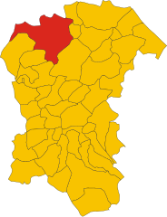
Кастильоне-Мессер-Раймондо (Castiglione Messer Raimondo, Castiglione Messer Raimondo)
.svg)
- коммуна Италии
 Hiking in Кастильоне-Мессер-Раймондо
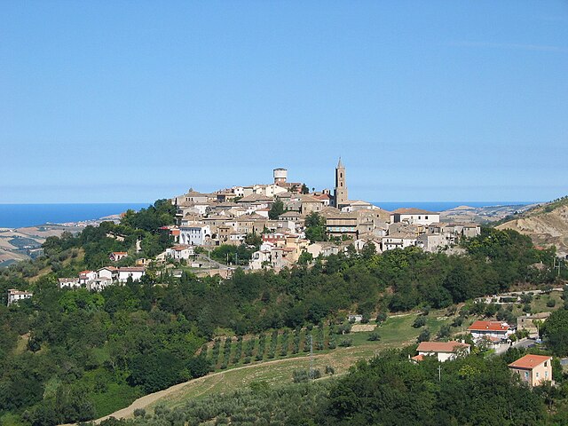
Castiglione Messer Raimondo is a charming hilltop town located in the Abruzzo region of Italy. It offers stunning landscapes, rich history, and a variety of hiking opportunities that cater to different skill levels. Here are some highlights of hiking in this area:
Scenic Trails
-
The Abruzzo National Park: While not directly in Castiglione Messer Raimondo, the park is a short drive away and offers numerous trails with breathtaking scenery, including mountains, lakes, and diverse wildlife. It's a great spot for both experienced hikers and beginners.
-
Local Trails: Within and around Castiglione Messer Raimondo, you can find trails that wind through vineyards, olive groves, and fields, providing picturesque views of the surrounding countryside.
Important Considerations
- Skill Level: Check the difficulty of the trails. Some may be more suited for experienced hikers while others are family-friendly.
- Weather: The weather can change rapidly in the mountains, so check the forecast and dress in layers.
- Equipment: Proper hiking footwear is recommended, and carrying water, snacks, a map, and a first-aid kit is always wise.
Local Recommendations
- Guided Tours: Consider joining a guided hiking tour to learn more about the local flora, fauna, and history.
- Cultural Exploration: After hiking, take some time to explore the historic town itself, which features beautiful architecture and local cuisine.
Best Times to Hike
- Spring and Fall: These seasons offer mild temperatures and stunning views with blooming flowers in spring and colorful foliage in fall.
Castiglione Messer Raimondo offers not just a chance to hike, but also to immerse yourself in the natural beauty and rich culture of the Abruzzo region. Make sure to plan ahead for a fulfilling outdoor experience!
- Страна:

- Почтовый код: 64034
- Телефонный код: 0861
- Код автомобильного номера: TE
- Координаты: 42° 32' 0" N, 13° 53' 0" E


- GPS треки (wikiloc): [Ссылка]
- Высота над уровнем моря: 306 м m
- Площадь: 30.69 кв.км
- Население: 2247
- Веб сайт: http://www.comune.castiglionemesserraimondo.te.it/
- Википедия русская: wiki(ru)
- Википедия английская: wiki(en)
- Википедия национальная: wiki(it)
- Хранилище Wikidata: Wikidata: Q51435
- Катеория в википедии: [Ссылка]
- код Freebase: [/m/0fs3z6]
- код GeoNames: Альт: [6536399]
- код VIAF: Альт: [130628512]
- ID отношения в OpenStreetMap: [42066]
- UN/LOCODE: [ITZHV]
- dmoz: Альт: [Regional/Europe/Italy/Abruzzo/Localities/Castiglione_Messer_Raimondo/]
- код ISTAT: 067013
- кадастровый код Италии: C316
Граничит с регионами:

Пенне
- коммуна Италии
Hiking in Пенне
Hiking in Penne, a charming town in the Abruzzo region of Italy, offers you a rich blend of natural beauty, historical significance, and cultural experiences. Here are some highlights and tips for hiking in this picturesque area:...
- Страна:
- Почтовый код: 65017
- Телефонный код: 085
- Код автомобильного номера: PE
- Координаты: 42° 27' 0" N, 13° 55' 0" E
- GPS треки (wikiloc): [Ссылка]
- Высота над уровнем моря: 438 м m
- Площадь: 91.2 кв.км
- Население: 12113
- Веб сайт: [Ссылка]

Бизенти
- коммуна Италии
Hiking in Бизенти
Bisenti is a charming town located in the Abruzzo region of Italy, surrounded by beautiful landscapes that are perfect for hiking enthusiasts. The area offers a mix of natural beauty, historical sites, and local culture, making it an excellent destination for hikers of all levels. Here are some highlights of hiking in and around Bisenti:...
- Страна:
- Почтовый код: 64033
- Телефонный код: 0861
- Код автомобильного номера: TE
- Координаты: 42° 32' 0" N, 13° 48' 0" E
- GPS треки (wikiloc): [Ссылка]
- Высота над уровнем моря: 274 м m
- Площадь: 30.88 кв.км
- Население: 1885
- Веб сайт: [Ссылка]
Кастиленти
- коммуна Италии
Hiking in Кастиленти
Castilenti is a charming town located in the Abruzzo region of Italy, nestled in the foothills of the Apennine Mountains. The area is known for its scenic beauty, rich history, and the variety of outdoor activities it offers, including hiking....
- Страна:
- Почтовый код: 64035
- Телефонный код: 0861
- Код автомобильного номера: TE
- Координаты: 42° 32' 0" N, 13° 55' 0" E
- GPS треки (wikiloc): [Ссылка]
- Высота над уровнем моря: 272 м m
- Площадь: 23.79 кв.км
- Население: 1419
- Веб сайт: [Ссылка]
Челлино-Аттаназьо
- коммуна Италии
Hiking in Челлино-Аттаназьо
Cellino Attanasio is a charming town located in the Abruzzo region of Italy, known for its picturesque landscapes, rolling hills, and rural charm. While it may not be as widely recognized as some other hiking destinations, it offers a variety of opportunities for outdoor enthusiasts looking to explore the natural beauty of the area....
- Страна:
- Почтовый код: 64036
- Телефонный код: 0861
- Код автомобильного номера: TE
- Координаты: 42° 35' 0" N, 13° 52' 0" E
- GPS треки (wikiloc): [Ссылка]
- Высота над уровнем моря: 443 м m
- Площадь: 43.94 кв.км
- Население: 2493
- Веб сайт: [Ссылка]
Монтефино
- коммуна Италии
Hiking in Монтефино
Montefino is a charming village located in the Abruzzo region of Italy, surrounded by stunning landscapes and an array of hiking opportunities. The area boasts hills, forests, and scenic views of the Adriatic Sea, making it an excellent destination for outdoor enthusiasts....
- Страна:
- Почтовый код: 64030
- Телефонный код: 0861
- Код автомобильного номера: TE
- Координаты: 42° 33' 0" N, 13° 53' 0" E
- GPS треки (wikiloc): [Ссылка]
- Высота над уровнем моря: 352 м m
- Площадь: 18.59 кв.км
- Население: 1018
- Веб сайт: [Ссылка]