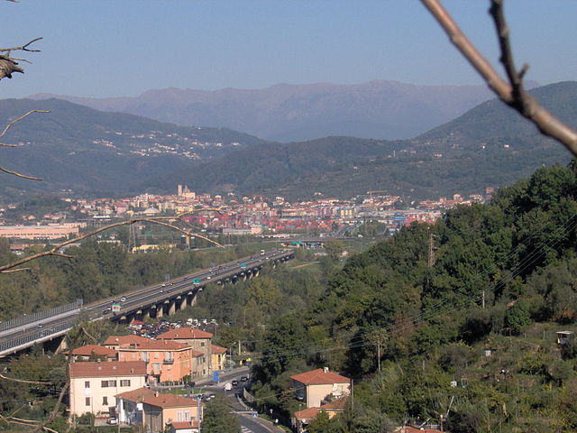
Болано (Bolano, Bolano)
.svg)
- коммуна Италии
 Hiking in Болано
Bolano, a charming town in the Liguria region of Italy, is surrounded by beautiful landscapes that make it an excellent destination for hiking enthusiasts. The area boasts a variety of trails that cater to different skill levels, from leisurely walks to challenging hikes, offering stunning views of the surrounding hills, vineyards, and the nearby Cinque Terre National Park.
Key Hiking Areas and Trails:
-
Cinque Terre National Park:
- While not directly in Bolano, it’s very accessible and offers some of the most famous hiking trails in Italy. The Sentiero Azzurro (Blue Trail) connects the five villages of the Cinque Terre and features breathtaking coastal views.
-
Luni Archaeological Site:
- Hike through the historical ruins, and enjoy the scenery along the way. The area offers picturesque views of the surrounding landscape and the coastline.
-
Trail to Mount Maggiore:
- This trail leads hikers through lush forests and provides fantastic vistas at the summit. It’s a great option for those looking for a moderate challenge.
-
Vineyard Trails:
- Explore the local vineyards and olive groves. There are many paths that weave through these beautiful landscapes, ideal for a leisurely hike and enjoying local produce.
Tips for Hiking in Bolano:
- Best Time to Hike: Spring (April to June) and fall (September to October) offer the best weather for hiking, with mild temperatures and fewer crowds.
- Preparation: Always check the weather before heading out, wear appropriate footwear, and carry water and snacks.
- Local Guidance: Consider hiring a local guide for the best experience and insights into the local flora, fauna, and history.
- Respect Nature: Follow the Leave No Trace principles to help preserve the natural beauty of the area.
Whether you are looking for a leisurely stroll or a rigorous climb, hiking in and around Bolano offers numerous opportunities to enjoy Italy's natural beauty.
- Страна:

- Почтовый код: 19020
- Телефонный код: 0187
- Код автомобильного номера: SP
- Координаты: 44° 11' 21" N, 9° 53' 43" E


- GPS треки (wikiloc): [Ссылка]
- Высота над уровнем моря: 317 м m
- Площадь: 14.57 кв.км
- Население: 7836
- Веб сайт: http://www.comune.bolano.sp.it/
- Википедия русская: wiki(ru)
- Википедия английская: wiki(en)
- Википедия национальная: wiki(it)
- Хранилище Wikidata: Wikidata: Q270000
- Катеория в википедии: [Ссылка]
- код Freebase: [/m/0ghx4d]
- код GeoNames: Альт: [6537067]
- код VIAF: Альт: [245447899]
- ID отношения в OpenStreetMap: [42917]
- код ISTAT: 011004
- кадастровый код Италии: A932
Граничит с регионами:


Фолло
- коммуна Италии
Hiking in Фолло
Follo, located in the Liguria region of Italy, is surrounded by beautiful landscapes, making it an attractive destination for hiking enthusiasts. This area offers a variety of trails that cater to different skill levels, from leisurely walks to more challenging hikes. Here are some highlights of hiking in Follo:...
- Страна:
- Почтовый код: 19020
- Телефонный код: 0187
- Код автомобильного номера: SP
- Координаты: 44° 9' 58" N, 9° 50' 54" E
- GPS треки (wikiloc): [Ссылка]
- Высота над уровнем моря: 70 м m
- Площадь: 23.27 кв.км
- Население: 6296
- Веб сайт: [Ссылка]

Санто-Стефано-ди-Магра
- коммуна Италии
Hiking in Санто-Стефано-ди-Магра
Santo Stefano di Magra is a charming town located in the Liguria region of Italy, nestled near the foothills of the Apuan Alps and the beautiful Cinque Terre National Park. Its strategic position makes it a great starting point for various hiking trails that offer stunning views of the surrounding landscapes....
- Страна:
- Почтовый код: 19037
- Телефонный код: 0187
- Код автомобильного номера: SP
- Координаты: 44° 9' 45" N, 9° 54' 54" E
- GPS треки (wikiloc): [Ссылка]
- Высота над уровнем моря: 54 м m
- Площадь: 13.85 кв.км
- Население: 9613
- Веб сайт: [Ссылка]


Веццано-Лигуре
- коммуна Италии
Hiking in Веццано-Лигуре
Vezzano Ligure is a charming village in the Liguria region of Italy, known for its beautiful landscapes and proximity to the Cinque Terre National Park. Hiking in and around Vezzano Ligure offers a blend of scenic views, historical trails, and a taste of local culture....
- Страна:
- Почтовый код: 19020
- Телефонный код: 0187
- Код автомобильного номера: SP
- Координаты: 44° 8' 28" N, 9° 53' 6" E
- GPS треки (wikiloc): [Ссылка]
- Высота над уровнем моря: 271 м m
- Площадь: 18.37 кв.км
- Население: 7320
- Веб сайт: [Ссылка]


Аулла
- коммуна Италии
Hiking in Аулла
Aulla is a charming town located in the Lunigiana region of Tuscany, Italy. Surrounded by lush hills and situated near the Magra River, Aulla serves as an excellent base for various hiking adventures in the area. Here are some highlights and tips for hiking in and around Aulla:...
- Страна:
- Почтовый код: 54011
- Телефонный код: 0187
- Код автомобильного номера: MS
- Координаты: 44° 13' 0" N, 9° 58' 0" E
- GPS треки (wikiloc): [Ссылка]
- Высота над уровнем моря: 64 м m
- Площадь: 59.99 кв.км
- Население: 11092
- Веб сайт: [Ссылка]


Поденцана
- коммуна Италии
Hiking in Поденцана
Podenzana is a charming village located in the province of Massa-Carrara in Tuscany, Italy. Surrounded by the beautiful Apuan Alps and nestled in the Apennine Mountains, it offers a variety of hiking opportunities with stunning views and picturesque landscapes....
- Страна:
- Почтовый код: 54010
- Телефонный код: 0187
- Код автомобильного номера: MS
- Координаты: 44° 12' 0" N, 9° 57' 0" E
- GPS треки (wikiloc): [Ссылка]
- Высота над уровнем моря: 312 м m
- Площадь: 17.1 кв.км
- Население: 2175
- Веб сайт: [Ссылка]


Трезана
- коммуна Италии
Hiking in Трезана
Tresana, located in the Lunigiana region of Tuscany, Italy, is a picturesque area that offers a variety of hiking opportunities. Nestled between the Apuan Alps and the Apennines, it is characterized by beautiful landscapes, charming villages, and rich history....
- Страна:
- Почтовый код: 54012
- Телефонный код: 0187
- Код автомобильного номера: MS
- Координаты: 44° 14' 0" N, 9° 57' 0" E
- GPS треки (wikiloc): [Ссылка]
- Высота над уровнем моря: 112 м m
- Площадь: 44.45 кв.км
- Население: 1999
- Веб сайт: [Ссылка]