Поденцана (Podenzana, Podenzana)
.svg)
- коммуна Италии
 Hiking in Поденцана
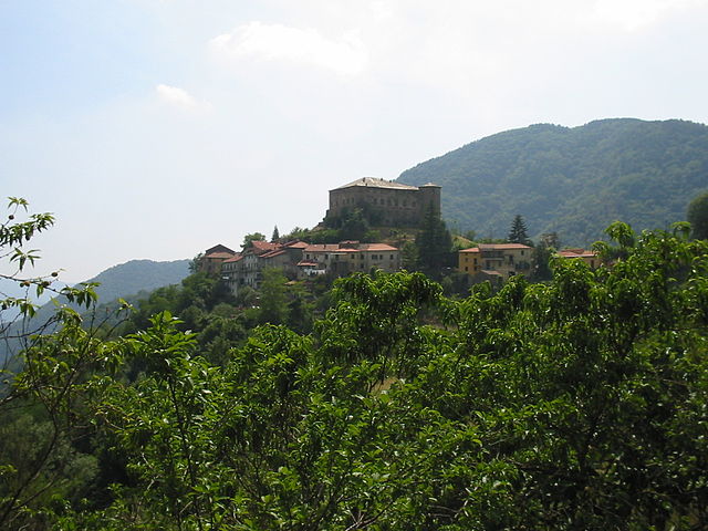
Podenzana is a charming village located in the province of Massa-Carrara in Tuscany, Italy. Surrounded by the beautiful Apuan Alps and nestled in the Apennine Mountains, it offers a variety of hiking opportunities with stunning views and picturesque landscapes.
Hiking Trails:
-
The Apuan Alps: These mountains are known for their dramatic limestone peaks and rich biodiversity. You can find numerous trails ranging from easy walks to more challenging hikes. One popular route is the "Via della Libertà," which offers panoramic views and can be accessed from Podenzana.
-
The Carrara Marble Quarries: Hiking in the nearby Carrara region allows you to explore the famous marble quarries. There are trails that lead you through the hills while providing insight into the marble extraction process.
-
Local Nature Trails: There are various shorter trails around Podenzana that take you through forests and along streams. These can be suitable for families, offering a chance to immerse yourself in the rural beauty of Tuscany.
Preparation Tips:
- Gear Up: Ensure you have suitable footwear (hiking boots are advisable) and clothing suitable for changing weather conditions.
- Stay Hydrated: Always carry enough water, especially during warmer months.
- Navigation: Having a map or hiking app is helpful, as some trails may not be well-marked.
- Wildlife: Be aware of local wildlife and maintain respect for nature.
Best Time to Hike:
- Spring and Fall: These seasons are ideal for hiking in Podenzana, as the weather is generally mild, and the scenery is lush during spring, while fall offers stunning foliage.
Additional Activities:
Besides hiking, Podenzana and its surroundings offer opportunities for cultural exploration, with historical sites, local cuisine, and the beautiful landscapes of Tuscany to enjoy. Don’t miss the chance to immerse yourself in the local culture and perhaps try some local foods after a day on the trails.
Always check current trail conditions and safety regulations before heading out, as weather and access can change. Happy hiking!
- Страна:

- Почтовый код: 54010
- Телефонный код: 0187
- Код автомобильного номера: MS
- Координаты: 44° 12' 0" N, 9° 57' 0" E


- GPS треки (wikiloc): [Ссылка]
- Высота над уровнем моря: 312 м m
- Площадь: 17.1 кв.км
- Население: 2175
- Веб сайт: http://www.comune.podenzana.ms.it
- Википедия русская: wiki(ru)
- Википедия английская: wiki(en)
- Википедия национальная: wiki(it)
- Хранилище Wikidata: Wikidata: Q52239
- Катеория в википедии: [Ссылка]
- код Freebase: [/m/0gl9zc]
- код GeoNames: Альт: [6536324]
- код VIAF: Альт: [239687772]
- ID отношения в OpenStreetMap: [42933]
- код ISTAT: 045013
- кадастровый код Италии: G746
Граничит с регионами:


Болано
- коммуна Италии
Hiking in Болано
Bolano, a charming town in the Liguria region of Italy, is surrounded by beautiful landscapes that make it an excellent destination for hiking enthusiasts. The area boasts a variety of trails that cater to different skill levels, from leisurely walks to challenging hikes, offering stunning views of the surrounding hills, vineyards, and the nearby Cinque Terre National Park....
- Страна:
- Почтовый код: 19020
- Телефонный код: 0187
- Код автомобильного номера: SP
- Координаты: 44° 11' 21" N, 9° 53' 43" E
- GPS треки (wikiloc): [Ссылка]
- Высота над уровнем моря: 317 м m
- Площадь: 14.57 кв.км
- Население: 7836
- Веб сайт: [Ссылка]

Каличе-аль-Корновильо
- коммуна Италии
Hiking in Каличе-аль-Корновильо
Calice al Cornoviglio, located in the Liguria region of Italy, is a charming village surrounded by the stunning landscapes of the Apuan Alps and close to the Cinque Terre National Park. It's a perfect spot for hikers looking for a mix of coastal and mountain trails, rich in natural beauty and cultural heritage....
- Страна:
- Почтовый код: 19020
- Телефонный код: 0187
- Код автомобильного номера: SP
- Координаты: 44° 14' 35" N, 9° 50' 11" E
- GPS треки (wikiloc): [Ссылка]
- Высота над уровнем моря: 402 м m
- Площадь: 33.75 кв.км
- Население: 1105
- Веб сайт: [Ссылка]


Фолло
- коммуна Италии
Hiking in Фолло
Follo, located in the Liguria region of Italy, is surrounded by beautiful landscapes, making it an attractive destination for hiking enthusiasts. This area offers a variety of trails that cater to different skill levels, from leisurely walks to more challenging hikes. Here are some highlights of hiking in Follo:...
- Страна:
- Почтовый код: 19020
- Телефонный код: 0187
- Код автомобильного номера: SP
- Координаты: 44° 9' 58" N, 9° 50' 54" E
- GPS треки (wikiloc): [Ссылка]
- Высота над уровнем моря: 70 м m
- Площадь: 23.27 кв.км
- Население: 6296
- Веб сайт: [Ссылка]


Аулла
- коммуна Италии
Hiking in Аулла
Aulla is a charming town located in the Lunigiana region of Tuscany, Italy. Surrounded by lush hills and situated near the Magra River, Aulla serves as an excellent base for various hiking adventures in the area. Here are some highlights and tips for hiking in and around Aulla:...
- Страна:
- Почтовый код: 54011
- Телефонный код: 0187
- Код автомобильного номера: MS
- Координаты: 44° 13' 0" N, 9° 58' 0" E
- GPS треки (wikiloc): [Ссылка]
- Высота над уровнем моря: 64 м m
- Площадь: 59.99 кв.км
- Население: 11092
- Веб сайт: [Ссылка]


Личчана-Нарди
- коммуна Италии
Hiking in Личчана-Нарди
Licciana Nardi is a charming village located in the Toscana region of Italy, nestled in the Apuan Alps. This area is known for its stunning natural scenery, rich history, and various hiking opportunities that cater to all skill levels....
- Страна:
- Почтовый код: 54016
- Телефонный код: 0187
- Код автомобильного номера: MS
- Координаты: 44° 16' 0" N, 10° 2' 0" E
- GPS треки (wikiloc): [Ссылка]
- Высота над уровнем моря: 210 м m
- Площадь: 55.68 кв.км
- Население: 4918
- Веб сайт: [Ссылка]


Трезана
- коммуна Италии
Hiking in Трезана
Tresana, located in the Lunigiana region of Tuscany, Italy, is a picturesque area that offers a variety of hiking opportunities. Nestled between the Apuan Alps and the Apennines, it is characterized by beautiful landscapes, charming villages, and rich history....
- Страна:
- Почтовый код: 54012
- Телефонный код: 0187
- Код автомобильного номера: MS
- Координаты: 44° 14' 0" N, 9° 57' 0" E
- GPS треки (wikiloc): [Ссылка]
- Высота над уровнем моря: 112 м m
- Площадь: 44.45 кв.км
- Население: 1999
- Веб сайт: [Ссылка]