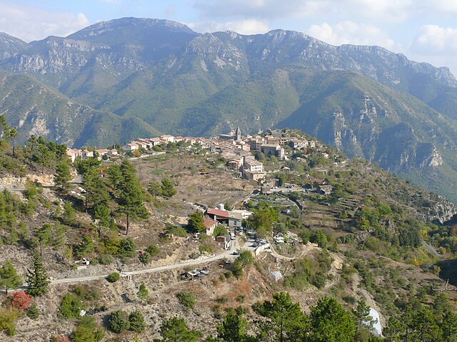
Бонсон (Bonson, Bonson)

- коммуна в департаменте Приморские Альпы, регион Прованс — Альпы — Лазурный Берег, Франция
 Hiking in Бонсон
Bonson, located in the Alpes-Maritimes department of the Provence-Alpes-Côte d'Azur region in France, offers a beautiful setting for hiking enthusiasts. Nestled in the hills above the Var River, this charming village is surrounded by stunning natural landscapes and offers a variety of trails that cater to different skill levels.
Hiking Trails
-
Les Sentiers de Bonson: The area boasts several marked trails, allowing hikers to explore the diverse flora and fauna of the region. These paths wind through terraced hillsides, olive groves, and forests, providing a combination of scenic views and a glimpse into the rural life of the area.
-
Circuit of the Gorges de la Vésubie: A short drive from Bonson, this circuit features dramatic gorges and diverse landscapes. Trails here can lead you along the river and up into the hills, offering more challenging routes for seasoned hikers.
-
Montagne de L’Audibergue: For a more challenging hike, consider venturing to the Montagne de L’Audibergue. The ascent rewards hikers with panoramic views of the surrounding mountains and valleys.
What to Expect
- Scenery: Expect breathtaking views of the Mediterranean mountains, lush valleys, and quaint village landscapes.
- Wildlife: Keep an eye out for local wildlife, including various bird species and other fauna.
- Seasonal Conditions: In spring and summer, the trails are often adorned with wildflowers. Fall offers a beautiful backdrop of autumn colors, while winter may bring a light dusting of snow at higher elevations.
Tips for Hiking in Bonson
- Footwear: Wear good hiking shoes with proper grip, as some trails may have rocky or uneven surfaces.
- Hydration: Carry sufficient water, especially in warmer months, as not all trails have access to water sources.
- Maps and Guides: While trails are usually marked, having a detailed map or a hiking app can be useful for navigation.
- Weather Check: Always check the weather forecast before heading out, as conditions can change rapidly in the mountains.
Overall, hiking in Bonson provides a wonderful opportunity to explore the stunning natural beauty of the French Riviera while enjoying a peaceful escape from busier tourist spots. Whether you're a seasoned hiker or just looking for a leisurely stroll, there are trails to suit your preferences.
- Страна:

- Почтовый код: 06830
- Координаты: 43° 51' 46" N, 7° 11' 24" E


- GPS треки (wikiloc): [Ссылка]
- Площадь: 6.72 кв.км
- Население: 737
- Веб сайт: http://www.bonson.org
- Википедия русская: wiki(ru)
- Википедия английская: wiki(en)
- Википедия национальная: wiki(fr)
- Хранилище Wikidata: Wikidata: Q845715
- Катеория в википедии: [Ссылка]
- код Freebase: [/m/03m59sl]
- код Freebase: [/m/03m59sl]
- код GeoNames: Альт: [6446677]
- код GeoNames: Альт: [6446677]
- номер SIREN: [210600219]
- номер SIREN: [210600219]
- код муниципалитета INSEE: 06021
- код муниципалитета INSEE: 06021
Граничит с регионами:

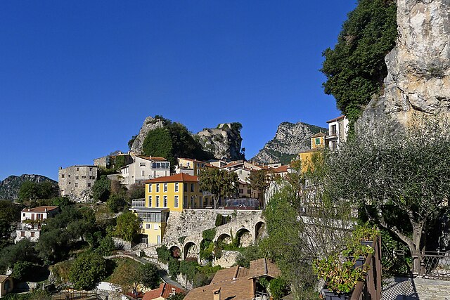
Ютель
- коммуна в департаменте Приморские Альпы, регион Прованс — Альпы — Лазурный Берег, Франция
Hiking in Ютель
Utelle is a charming village in the Alpes-Maritimes department of the French Riviera, surrounded by stunning natural landscapes, making it an excellent destination for hiking enthusiasts. Here are some highlights about hiking in and around Utelle:...
- Страна:
- Почтовый код: 06450
- Координаты: 43° 55' 9" N, 7° 15' 51" E
- GPS треки (wikiloc): [Ссылка]
- Площадь: 67.97 кв.км
- Население: 832


Левенс
- коммуна в департаменте Приморские Альпы, регион Прованс — Альпы — Лазурный Берег, Франция
Hiking in Левенс
Levens, a small commune in the Alpes-Maritimes department in the Provence-Alpes-Côte d'Azur region of France, offers beautiful hiking opportunities surrounded by picturesque landscapes, including mountains and valleys. Here are some key highlights about hiking in and around Levens:...
- Страна:
- Почтовый код: 06670
- Координаты: 43° 51' 39" N, 7° 13' 28" E
- GPS треки (wikiloc): [Ссылка]
- Площадь: 29.85 кв.км
- Население: 4741


Турет-дю-Шато
- коммуна в департаменте Приморские Альпы, регион Прованс — Альпы — Лазурный Берег, Франция
Hiking in Турет-дю-Шато
Tourette-du-Château is a charming commune located in the Alpes-Maritimes department in the Provence-Alpes-Côte d'Azur region of southeastern France. This picturesque area offers a variety of hiking opportunities amidst stunning natural scenery, including beautiful landscapes, rolling hills, and rich flora and fauna....
- Страна:
- Почтовый код: 06830
- Координаты: 43° 52' 56" N, 7° 8' 34" E
- GPS треки (wikiloc): [Ссылка]
- Высота над уровнем моря: 900 м m
- Площадь: 9.74 кв.км
- Население: 126

Жилет
- коммуна в департаменте Приморские Альпы, регион Прованс — Альпы — Лазурный Берег, Франция
Hiking in Жилет
Gillette, Wyoming, is surrounded by a variety of outdoor recreational opportunities for hiking enthusiasts. The area is characterized by scenic landscapes, rolling hills, and rugged terrain typical of the high plains region. Here are a few hiking options and considerations while exploring the area:...
- Страна:
- Почтовый код: 06830
- Координаты: 43° 50' 58" N, 7° 9' 49" E
- GPS треки (wikiloc): [Ссылка]
- Площадь: 10.18 кв.км
- Население: 1536


Ла-Рокет-сюр-Вар
- коммуна в департаменте Приморские Альпы, регион Прованс — Альпы — Лазурный Берег, Франция
Hiking in Ла-Рокет-сюр-Вар
La Roquette-sur-Var is a charming village located in the Alpes-Maritimes department in the Provence-Alpes-Côte d'Azur region of France. It offers access to beautiful natural landscapes, making it a great spot for hiking enthusiasts. Here are some highlights and tips for hiking in and around La Roquette-sur-Var:...
- Страна:
- Почтовый код: 06670
- Координаты: 43° 49' 41" N, 7° 11' 56" E
- GPS треки (wikiloc): [Ссылка]
- Площадь: 3.99 кв.км
- Население: 906

Ревест-ле-Рош
- коммуна в департаменте Приморские Альпы, регион Прованс — Альпы — Лазурный Берег, Франция
Hiking in Ревест-ле-Рош
Revest-les-Roches, located in the Provence-Alpes-Côte d'Azur region of France, is a charming destination for hikers, offering stunning landscapes, natural beauty, and rich history. Nestled in the hills near the city of Toulon, it features a mix of rugged terrain, scenic trails, and panoramic views of the surrounding countryside and the Mediterranean Sea....
- Страна:
- Почтовый код: 06830
- Координаты: 43° 52' 50" N, 7° 9' 26" E
- GPS треки (wikiloc): [Ссылка]
- Площадь: 8.61 кв.км
- Население: 230