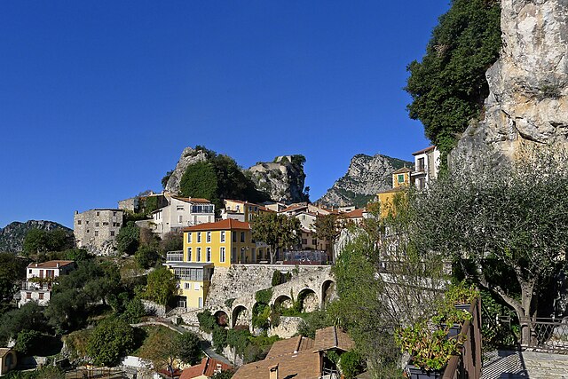
Ла-Рокет-сюр-Вар (La Roquette-sur-Var, La Roquette-sur-Var)

- коммуна в департаменте Приморские Альпы, регион Прованс — Альпы — Лазурный Берег, Франция
 Hiking in Ла-Рокет-сюр-Вар
La Roquette-sur-Var is a charming village located in the Alpes-Maritimes department in the Provence-Alpes-Côte d'Azur region of France. It offers access to beautiful natural landscapes, making it a great spot for hiking enthusiasts. Here are some highlights and tips for hiking in and around La Roquette-sur-Var:
Trails and Routes
-
Local Trails: There are various marked trails starting from La Roquette-sur-Var that lead you through the surrounding hills and valleys. These trails often offer stunning views of the Var valley and the surrounding mountains.
-
Cime de Pierlas: For a more challenging hike, consider the route to Cime de Pierlas. This trail provides breathtaking panoramic views and is suitable for those with a good level of fitness.
-
GR hiking path: The Grande Randonnée (GR) trails also pass through the region. The GR5, for instance, offers a long-distance trek that features diverse landscapes, including forests, river gorges, and charming villages.
Nature and Scenery
- The area is characterized by unique geological features, rich flora, and fauna. You can enjoy hikes through fragrant Mediterranean scrub, oak forests, and along the banks of the Var River.
- Wildlife spotting is a possibility, so keep an eye out for local birds and other animals.
Tips for Hiking
- Safety: Always check the weather before heading out, as conditions can change rapidly in mountainous areas. Ensure you carry enough water, snacks, and a basic first-aid kit.
- Gear: Proper hiking shoes and comfortable clothing are essential. If you're planning to hike a longer trail, consider bringing a trekking pole for added stability.
- Navigation: While trails are often marked, having a map or a GPS device can be helpful, especially for more remote routes.
- Local Regulations: Be sure to respect local regulations regarding nature conservation and follow Leave No Trace principles to preserve the beauty of the area.
Nearby Attractions
After a day of hiking, you can explore the village itself, enjoy regional cuisine at local restaurants, or visit nearby attractions such as the picturesque town of Vence or the stunning landscapes of the Mercantour National Park.
Whether you are an experienced hiker or a beginner, La Roquette-sur-Var has something to offer for everyone looking to enjoy the great outdoors in this beautiful part of France.
- Страна:

- Почтовый код: 06670
- Координаты: 43° 49' 41" N, 7° 11' 56" E


- GPS треки (wikiloc): [Ссылка]
- Площадь: 3.99 кв.км
- Население: 906
- Википедия русская: wiki(ru)
- Википедия английская: wiki(en)
- Википедия национальная: wiki(fr)
- Хранилище Wikidata: Wikidata: Q540730
- Катеория в википедии: [Ссылка]
- код Freebase: [/m/03m4z57]
- код Freebase: [/m/03m4z57]
- код GeoNames: Альт: [3006689]
- код GeoNames: Альт: [3006689]
- номер SIREN: [210601092]
- номер SIREN: [210601092]
- код BNF: [125152170]
- код BNF: [125152170]
- код VIAF: Альт: [150257620]
- код VIAF: Альт: [150257620]
- код LCNAF: Альт: [n95085647]
- код LCNAF: Альт: [n95085647]
- WOEID: [22756755]
- WOEID: [22756755]
- код муниципалитета INSEE: 06109
- код муниципалитета INSEE: 06109
Граничит с регионами:


Сен-Блез
- коммуна в департаменте Приморские Альпы, регион Прованс — Альпы — Лазурный Берег, Франция
Hiking in Сен-Блез
Saint-Blaise, situated in the Alpes-Maritimes region of France, offers a beautiful backdrop for hiking enthusiasts. Nestled near Nice and the Mediterranean coast, it provides not only stunning views but also a variety of trails suitable for different skill levels....
- Страна:
- Почтовый код: 06670
- Координаты: 43° 49' 18" N, 7° 14' 15" E
- GPS треки (wikiloc): [Ссылка]
- Площадь: 8.04 кв.км
- Население: 1013


Левенс
- коммуна в департаменте Приморские Альпы, регион Прованс — Альпы — Лазурный Берег, Франция
Hiking in Левенс
Levens, a small commune in the Alpes-Maritimes department in the Provence-Alpes-Côte d'Azur region of France, offers beautiful hiking opportunities surrounded by picturesque landscapes, including mountains and valleys. Here are some key highlights about hiking in and around Levens:...
- Страна:
- Почтовый код: 06670
- Координаты: 43° 51' 39" N, 7° 13' 28" E
- GPS треки (wikiloc): [Ссылка]
- Площадь: 29.85 кв.км
- Население: 4741

Жилет
- коммуна в департаменте Приморские Альпы, регион Прованс — Альпы — Лазурный Берег, Франция
Hiking in Жилет
Gillette, Wyoming, is surrounded by a variety of outdoor recreational opportunities for hiking enthusiasts. The area is characterized by scenic landscapes, rolling hills, and rugged terrain typical of the high plains region. Here are a few hiking options and considerations while exploring the area:...
- Страна:
- Почтовый код: 06830
- Координаты: 43° 50' 58" N, 7° 9' 49" E
- GPS треки (wikiloc): [Ссылка]
- Площадь: 10.18 кв.км
- Население: 1536


Бонсон
- коммуна в департаменте Приморские Альпы, регион Прованс — Альпы — Лазурный Берег, Франция
Hiking in Бонсон
Bonson, located in the Alpes-Maritimes department of the Provence-Alpes-Côte d'Azur region in France, offers a beautiful setting for hiking enthusiasts. Nestled in the hills above the Var River, this charming village is surrounded by stunning natural landscapes and offers a variety of trails that cater to different skill levels....
- Страна:
- Почтовый код: 06830
- Координаты: 43° 51' 46" N, 7° 11' 24" E
- GPS треки (wikiloc): [Ссылка]
- Площадь: 6.72 кв.км
- Население: 737
- Веб сайт: [Ссылка]


Сен-Мартен-дю-Вар
- коммуна в департаменте Приморские Альпы, регион Прованс — Альпы — Лазурный Берег, Франция
Hiking in Сен-Мартен-дю-Вар
Saint-Martin-du-Var is a charming village located in the Alpes-Maritimes region of France, near Nice. The area is less known than more popular destinations in the French Riviera, making it a great spot for a peaceful hiking experience amidst stunning natural surroundings....
- Страна:
- Почтовый код: 06670
- Координаты: 43° 49' 20" N, 7° 11' 32" E
- GPS треки (wikiloc): [Ссылка]
- Площадь: 5.59 кв.км
- Население: 2882
- Веб сайт: [Ссылка]