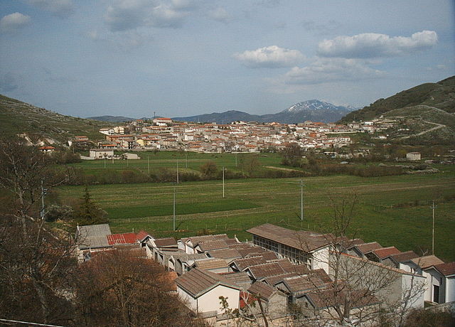
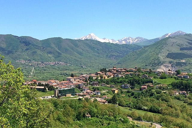
Борбона (Borbona, Borbona)
.svg)
- коммуна Италии
 Hiking in Борбона
Borbona, located in the Lazio region of Italy, is a charming area that offers potential for hiking enthusiasts. Nestled within the beautiful landscape of the Apennines, Borbona is surrounded by lush forests, rolling hills, and picturesque mountain views, making it an ideal destination for outdoor activities.
Hiking Trails
-
Regional Park of the Sirente-Velino: This nearby park features various trails that cater to different skill levels. You can explore scenic paths that showcase stunning natural beauty, wildlife, and unique flora.
-
Monte Velino: A popular destination for more experienced hikers, the trails leading to the summit offer breathtaking views. The trail can be steep and demanding, so proper preparation is essential.
-
Historical Trails: Some paths around Borbona may lead you through historical sites, small villages, and ancient ruins, combining hiking with rich cultural experiences.
Best Time to Hike
The best months for hiking in Borbona are typically from late spring (May and June) to early autumn (September and October). These months generally offer mild weather and less precipitation. Summers can be warm, so early morning hikes or evening excursions are recommended to avoid the heat.
Preparation and Tips
- Equipment: Make sure to wear sturdy hiking boots and carry essentials like water, snacks, a map, or a GPS device.
- Weather: Check local weather conditions before heading out, as mountain weather can change rapidly.
- Local Guidance: Consider hiring a local guide or joining a guided tour, especially if you’re unfamiliar with the area or if you're exploring more challenging trails.
Wildlife and Nature
Hiking in Borbona provides opportunities to observe local wildlife, including various bird species and possibly even deer. The region's diverse flora adds to the beauty of the trails.
Conclusion
Borbona offers a rich hiking experience with its stunning natural landscapes and cultural heritage. Whether you're strolling through gentle hills or tackling more challenging trails, you're sure to enjoy the beauty and tranquility of this Italian gem. Always prioritize safety, plan ahead, and embrace the adventure!
- Страна:

- Почтовый код: 02010
- Телефонный код: 0746
- Код автомобильного номера: RI
- Координаты: 42° 31' 0" N, 13° 8' 0" E


- GPS треки (wikiloc): [Ссылка]
- Высота над уровнем моря: 760 м m
- Площадь: 47.96 кв.км
- Население: 596
- Веб сайт: http://www.comune.borbona.rieti.it/
- Википедия русская: wiki(ru)
- Википедия английская: wiki(en)
- Википедия национальная: wiki(it)
- Хранилище Wikidata: Wikidata: Q223459
- Катеория в википедии: [Ссылка]
- код Freebase: [/m/0gm4xm]
- код GeoNames: Альт: [6538644]
- код VIAF: Альт: [244327155]
- ID отношения в OpenStreetMap: [42030]
- код GND: Альт: [7613238-9]
- код ISTAT: 057006
- кадастровый код Италии: A981
Граничит с регионами:


Антродоко
- коммуна Италии
Hiking in Антродоко
Antrodoco, a town located in the province of Rieti in central Italy, is situated in the Apennine mountain range and offers beautiful hiking opportunities. This area is characterized by its stunning natural landscapes, charming villages, and rich cultural heritage....
- Страна:
- Почтовый код: 02013
- Телефонный код: 0746
- Код автомобильного номера: RI
- Координаты: 42° 25' 0" N, 13° 5' 0" E
- GPS треки (wikiloc): [Ссылка]
- Высота над уровнем моря: 525 м m
- Площадь: 63.9 кв.км
- Население: 2498
- Веб сайт: [Ссылка]
Читтареале
- коммуна Италии
Hiking in Читтареале
Cittareale, a charming village located in the province of Rieti in Italy's Lazio region, is surrounded by stunning natural landscapes, making it an excellent destination for hiking enthusiasts. The area is characterized by its mountainous terrain, dense forests, and picturesque views, which provide a variety of trails for all skill levels....
- Страна:
- Почтовый код: 02010
- Телефонный код: 0746
- Код автомобильного номера: RI
- Координаты: 42° 37' 0" N, 13° 10' 0" E
- GPS треки (wikiloc): [Ссылка]
- Высота над уровнем моря: 952 м m
- Площадь: 59.67 кв.км
- Население: 462
- Веб сайт: [Ссылка]
Мичильяно
- коммуна Италии
Hiking in Мичильяно
Micigliano is a charming village located in the province of Rieti in the Lazio region of Italy. Nestled in the Sabina hills, it offers picturesque landscapes and a tranquil environment, making it a great destination for hiking enthusiasts....
- Страна:
- Почтовый код: 02010
- Телефонный код: 0746
- Код автомобильного номера: RI
- Координаты: 42° 27' 0" N, 13° 3' 0" E
- GPS треки (wikiloc): [Ссылка]
- Высота над уровнем моря: 925 м m
- Площадь: 36.85 кв.км
- Население: 133
- Веб сайт: [Ссылка]
Поста
- коммуна Италии
Hiking in Поста
Posta, a small town in the province of Rieti in the Lazio region of Italy, is surrounded by beautiful natural landscapes that make it an excellent destination for hiking enthusiasts. Situated in the Apennines, Posta offers access to various trails that highlight the area's stunning mountainous terrain, rich flora and fauna, and panoramic views....
- Страна:
- Почтовый код: 02019
- Телефонный код: 0746
- Код автомобильного номера: RI
- Координаты: 42° 31' 0" N, 13° 6' 0" E
- GPS треки (wikiloc): [Ссылка]
- Высота над уровнем моря: 721 м m
- Площадь: 66.01 кв.км
- Население: 649
- Веб сайт: [Ссылка]

Каньяно-Амитерно
- коммуна Италии
Hiking in Каньяно-Амитерно
Cagnano Amiterno is a small village located in the province of L'Aquila in the Abruzzo region of Italy, nestled in the beautiful Apennine mountains. The area is a fantastic destination for hiking enthusiasts, offering a mix of stunning landscapes, rugged terrain, and a rich natural environment....
- Страна:
- Почтовый код: 67012
- Телефонный код: 0862
- Код автомобильного номера: AQ
- Координаты: 42° 27' 30" N, 13° 13' 44" E
- GPS треки (wikiloc): [Ссылка]
- Высота над уровнем моря: 841 м m
- Площадь: 61.32 кв.км
- Население: 1262
- Веб сайт: [Ссылка]

Монтереале
- коммуна Италии
Hiking in Монтереале
Montereale, located in the Abruzzo region of central Italy, offers a stunning landscape for hiking enthusiasts. Nestled in the Apennine mountains, this picturesque town is surrounded by rolling hills, lush forests, and breathtaking views, making it an excellent destination for outdoor activities....
- Страна:
- Почтовый код: 67015
- Телефонный код: 0862
- Код автомобильного номера: AQ
- Координаты: 42° 31' 22" N, 13° 14' 55" E
- GPS треки (wikiloc): [Ссылка]
- Высота над уровнем моря: 945 м m
- Площадь: 104.42 кв.км
- Население: 2483
- Веб сайт: [Ссылка]