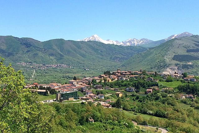
Каньяно-Амитерно (Cagnano Amiterno, Cagnano Amiterno)
.svg)
- коммуна Италии
 Hiking in Каньяно-Амитерно
Cagnano Amiterno is a small village located in the province of L'Aquila in the Abruzzo region of Italy, nestled in the beautiful Apennine mountains. The area is a fantastic destination for hiking enthusiasts, offering a mix of stunning landscapes, rugged terrain, and a rich natural environment.
Hiking Trails
-
Parco Nazionale del Gran Sasso e Monti della Laga: Cagnano Amiterno is near this national park, which features various trails suitable for different skill levels. You can find routes that lead to breathtaking viewpoints, alpine meadows, and diverse wildlife.
-
Monte Cagno: A popular hiking destination that offers panoramic views of the surrounding mountains and valleys. The trail to the summit is challenging but rewarding, ideal for experienced hikers.
-
Local Trails: There are several less-known paths and trails around Cagnano that can provide a more tranquil experience, allowing you to explore the natural beauty and possibly encounter local flora and fauna.
Tips for Hiking in Cagnano Amiterno
-
Check Weather Conditions: The weather can change rapidly in mountainous areas, so it's essential to check forecasts before heading out.
-
Wear Appropriate Gear: Sturdy hiking boots, layered clothing, and a good backpack are crucial. Bring enough water and snacks.
-
Stay on Marked Trails: To preserve the environment and ensure your safety, stick to established paths and follow any trail signage.
-
Respect Wildlife and Nature: Keep a distance from wildlife, do not pick plants, and take all trash with you.
-
Safety First: If you're not familiar with the area, consider hiring a local guide or joining an organized hike to ensure you stay safe.
Local Culture and Cuisine
After a day of hiking, you can enjoy the local cuisine in Cagnano Amiterno, where traditional dishes often feature local ingredients. Don't miss trying regional specialties like "arrosticini" (grilled skewered meat) and various pasta dishes.
Conclusion
Hiking in Cagnano Amiterno provides an excellent opportunity to connect with nature, explore mountainous terrain, and enjoy the tranquility of rural Italy. Whether you're seeking challenging hikes or more leisurely walks, the area has something to offer for everyone.
- Страна:

- Почтовый код: 67012
- Телефонный код: 0862
- Код автомобильного номера: AQ
- Координаты: 42° 27' 30" N, 13° 13' 44" E


- GPS треки (wikiloc): [Ссылка]
- Высота над уровнем моря: 841 м m
- Площадь: 61.32 кв.км
- Население: 1262
- Веб сайт: http://comune.cagnanoamiterno.aq.it/
- Википедия русская: wiki(ru)
- Википедия английская: wiki(en)
- Википедия национальная: wiki(it)
- Хранилище Wikidata: Wikidata: Q50057
- Катеория в википедии: [Ссылка]
- код Freebase: [/m/0fg49g]
- код GeoNames: Альт: [6543288]
- ID отношения в OpenStreetMap: [42021]
- Google Maps Customer ID: [10483210628423523741]
- код ISTAT: 066013
- кадастровый код Италии: B358
Граничит с регионами:


Антродоко
- коммуна Италии
Hiking in Антродоко
Antrodoco, a town located in the province of Rieti in central Italy, is situated in the Apennine mountain range and offers beautiful hiking opportunities. This area is characterized by its stunning natural landscapes, charming villages, and rich cultural heritage....
- Страна:
- Почтовый код: 02013
- Телефонный код: 0746
- Код автомобильного номера: RI
- Координаты: 42° 25' 0" N, 13° 5' 0" E
- GPS треки (wikiloc): [Ссылка]
- Высота над уровнем моря: 525 м m
- Площадь: 63.9 кв.км
- Население: 2498
- Веб сайт: [Ссылка]
Борбона
- коммуна Италии
Hiking in Борбона
Borbona, located in the Lazio region of Italy, is a charming area that offers potential for hiking enthusiasts. Nestled within the beautiful landscape of the Apennines, Borbona is surrounded by lush forests, rolling hills, and picturesque mountain views, making it an ideal destination for outdoor activities....
- Страна:
- Почтовый код: 02010
- Телефонный код: 0746
- Код автомобильного номера: RI
- Координаты: 42° 31' 0" N, 13° 8' 0" E
- GPS треки (wikiloc): [Ссылка]
- Высота над уровнем моря: 760 м m
- Площадь: 47.96 кв.км
- Население: 596
- Веб сайт: [Ссылка]


Л’Акуила
- коммуна Италии
Hiking in Л’Акуила
L'Aquila, located in the Abruzzo region of Italy, is surrounded by stunning landscapes, making it a great destination for hiking enthusiasts. The area is characterized by the Gran Sasso and Monti della Laga National Park, which offers a variety of trails suited for all skill levels, from casual walkers to experienced hikers. Here are some highlights of hiking in L'Aquila:...
- Страна:
- Почтовый код: 67100
- Телефонный код: 0862
- Координаты: 42° 21' 14" N, 13° 23' 31" E
- GPS треки (wikiloc): [Ссылка]
- Высота над уровнем моря: 714 м m
- Площадь: 466.87 кв.км
- Население: 69627
- Веб сайт: [Ссылка]
Барете
- коммуна Италии
Hiking in Барете
Barete is an interesting destination for hiking, located in the Abruzzo region of Italy. The area is known for its beautiful landscapes, diverse wildlife, and a variety of trails suitable for different skill levels. Here are some key points to consider when planning a hike in Barete:...
- Страна:
- Почтовый код: 67010
- Телефонный код: 0862
- Код автомобильного номера: AQ
- Координаты: 42° 27' 5" N, 13° 16' 59" E
- GPS треки (wikiloc): [Ссылка]
- Высота над уровнем моря: 800 м m
- Площадь: 24.59 кв.км
- Население: 683
- Веб сайт: [Ссылка]

Монтереале
- коммуна Италии
Hiking in Монтереале
Montereale, located in the Abruzzo region of central Italy, offers a stunning landscape for hiking enthusiasts. Nestled in the Apennine mountains, this picturesque town is surrounded by rolling hills, lush forests, and breathtaking views, making it an excellent destination for outdoor activities....
- Страна:
- Почтовый код: 67015
- Телефонный код: 0862
- Код автомобильного номера: AQ
- Координаты: 42° 31' 22" N, 13° 14' 55" E
- GPS треки (wikiloc): [Ссылка]
- Высота над уровнем моря: 945 м m
- Площадь: 104.42 кв.км
- Население: 2483
- Веб сайт: [Ссылка]