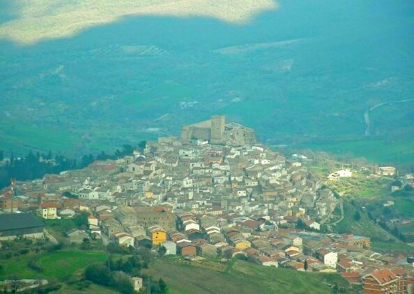
Бовино (Bovino, Bovino)
.svg)
- коммуна в регионе Апулия, Италия
 Hiking in Бовино
Bovino, a picturesque town in the Apennine Mountains of Italy, is known for its rich history, stunning landscapes, and hiking opportunities that cater to various skill levels. Here’s what you should know about hiking in and around Bovino:
Trails and Routes
-
Parco Nazionale del Gargano: While not directly in Bovino, this national park is nearby and offers numerous hiking trails with diverse ecosystems, including forests, mountains, and coastline. Several trails suitable for day hikes can be accessed from Bovino.
-
Mountain Trails: The hills surrounding Bovino offer a variety of trails, some leading to ancient ruins or offering panoramic views of the surrounding countryside. You can explore paths that meander through olive groves, vineyards, and dense forests.
-
Historic Trails: Some trails connect Bovino to historical sites and neighboring medieval towns, allowing hikers to appreciate the cultural heritage while enjoying nature.
Hiking Conditions
- Weather: The best times for hiking in Bovino are during spring (April to June) and autumn (September to October), when temperatures are mild, and the scenery is lush.
- Footwear: Sturdy hiking boots are recommended due to uneven terrain.
- Difficulty Levels: Trails range from easy walks suitable for families to more challenging hikes for experienced trekkers.
Preparation
- Maps and Guides: It's advisable to obtain a detailed map or a local guide. Consider joining organized hiking groups or tours to enhance your experience and learn more about the local flora and fauna.
- Supplies: Always carry enough water, snacks, and a first aid kit. Mobile coverage may be limited in remote areas, so planning ahead is essential.
- Local Flora and Fauna: Keep an eye out for local wildlife and unique plant species as you hike.
Attractions
- Scenic Views: Look for vantage points that offer breathtaking views of the surrounding valleys and mountains.
- Cultural Insights: As you hike, you may encounter traditional stone houses, ancient churches, and remnants of old fortifications that tell the story of the region.
Sustainability
Respect the environment by sticking to marked trails, not disturbing wildlife, and carrying out all trash.
Whether you're a beginner looking for leisurely walks or an experienced hiker seeking challenging trails, Bovino's stunning landscapes and rich history make it a fantastic hiking destination. Always ensure to check local regulations and trail conditions before heading out. Happy hiking!
- Страна:

- Почтовый код: 71023
- Телефонный код: 0881
- Код автомобильного номера: FG
- Координаты: 41° 15' 0" N, 15° 21' 0" E


- GPS треки (wikiloc): [Ссылка]
- Высота над уровнем моря: 647 м m
- Площадь: 84.93 кв.км
- Население: 3256
- Веб сайт: http://www.comunebovino.it/
- Википедия русская: wiki(ru)
- Википедия английская: wiki(en)
- Википедия национальная: wiki(it)
- Хранилище Wikidata: Wikidata: Q51895
- Катеория в википедии: [Ссылка]
- код Freebase: [/m/0ft8wz]
- код GeoNames: Альт: [3181645]
- код BNF: [15583527h]
- код VIAF: Альт: [235654042]
- ID отношения в OpenStreetMap: [41162]
- код GND: Альт: [4412703-0]
- код тезауруса PACTOLS: [pcrtRNr6JBSg0S]
- код Цифрового атласа Римской империи: [22556]
- код ISTAT: 071007
- кадастровый код Италии: B104
Граничит с регионами:


Аккадия
- коммуна Италии
Hiking in Аккадия
Acadia National Park, located on Mount Desert Island off the coast of Maine, is a stunning destination for hikers and outdoor enthusiasts. Here are some key details about hiking in Acadia:...
- Страна:
- Почтовый код: 71021
- Телефонный код: 0881
- Код автомобильного номера: FG
- Координаты: 41° 10' 0" N, 15° 20' 0" E
- GPS треки (wikiloc): [Ссылка]
- Высота над уровнем моря: 650 м m
- Площадь: 30.74 кв.км
- Население: 2338
- Веб сайт: [Ссылка]
Кастеллуччо-дей-Саури
- коммуна Италии
Hiking in Кастеллуччо-дей-Саури
Castelluccio dei Sauri, a charming village located in the Apennine Mountains of Italy, is an excellent destination for hiking enthusiasts. Nestled in the province of Foggia, in the region of Puglia, this area is characterized by its stunning landscapes, varied terrain, and rich biodiversity....
- Страна:
- Почтовый код: 71025
- Телефонный код: 0881
- Код автомобильного номера: FG
- Координаты: 41° 18' 0" N, 15° 29' 0" E
- GPS треки (wikiloc): [Ссылка]
- Высота над уровнем моря: 284 м m
- Площадь: 51.47 кв.км
- Население: 2102
- Веб сайт: [Ссылка]
Деличето
- коммуна Италии
Hiking in Деличето
Deliceto is a charming small town located in the Apulia region of southern Italy, known for its beautiful landscapes, historical architecture, and natural surroundings. While it may not be as widely recognized for hiking as some other destinations, it offers several opportunities for outdoor enthusiasts to explore its scenic countryside and nearby areas....
- Страна:
- Почтовый код: 71026
- Телефонный код: 0881
- Код автомобильного номера: FG
- Координаты: 41° 13' 0" N, 15° 23' 0" E
- GPS треки (wikiloc): [Ссылка]
- Высота над уровнем моря: 575 м m
- Площадь: 75.85 кв.км
- Население: 3725
- Веб сайт: [Ссылка]
Орсара-ди-Пулья
- коммуна Италии
Hiking in Орсара-ди-Пулья
Orsara di Puglia is a picturesque village located in the province of Foggia in the Apulia region of Italy. Surrounded by the lush landscapes of the Gargano National Park and the rolling hills of the Daunian Mountains, it offers a variety of hiking opportunities for nature enthusiasts and adventure seekers....
- Страна:
- Почтовый код: 71027
- Телефонный код: 0881
- Код автомобильного номера: FG
- Координаты: 41° 17' 0" N, 15° 16' 0" E
- GPS треки (wikiloc): [Ссылка]
- Высота над уровнем моря: 635 м m
- Площадь: 83.01 кв.км
- Население: 2704
- Веб сайт: [Ссылка]


Панни
- коммуна Италии
Hiking in Панни
Panni, often recognized for its stunning landscapes and rich biodiversity, offers a variety of hiking experiences suitable for adventurers of all levels. Here are some key aspects to consider when planning a hike in this area:...
- Страна:
- Почтовый код: 71020
- Телефонный код: 0881
- Код автомобильного номера: FG
- Координаты: 41° 13' 15" N, 15° 16' 32" E
- GPS треки (wikiloc): [Ссылка]
- Высота над уровнем моря: 801 м m
- Площадь: 32.71 кв.км
- Население: 774
- Веб сайт: [Ссылка]