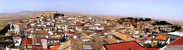
Деличето (Deliceto, Deliceto)
.svg)
- коммуна Италии
 Hiking in Деличето
Deliceto is a charming small town located in the Apulia region of southern Italy, known for its beautiful landscapes, historical architecture, and natural surroundings. While it may not be as widely recognized for hiking as some other destinations, it offers several opportunities for outdoor enthusiasts to explore its scenic countryside and nearby areas.
Hiking Opportunities in Deliceto:
-
Natural Trails: The surrounding hills and countryside provide a range of trails suitable for hiking. You can find paths that take you through fields, forests, and olive groves, showcasing the area’s picturesque scenery.
-
Monte Crispiano: The nearby Monte Crispiano offers a more challenging hike. This mountain provides trails that reward hikers with stunning panoramic views of the surrounding landscape, especially beautiful during sunrise or sunset.
-
Historic Routes: Exploring the town itself can also be part of your hiking experience. Deliceto is known for its historical sites, including old churches and architecture. Combining hiking with cultural exploration can make for a fulfilling day.
-
Nearby Nature Parks: Consider visiting nearby natural parks, which may provide more extensive trail networks. Parks such as the Gargano National Park are a short drive away and offer various levels of hiking trails that cater to all abilities.
Tips for Hiking in Deliceto:
- Best Season: Spring (April to June) and fall (September to October) are ideal times for hiking, as temperatures are mild and the landscapes are vibrant.
- Hydration: Always carry enough water, especially if you venture on longer hikes.
- Footwear: Wear good hiking shoes to navigate uneven terrain comfortably.
- Navigation: Familiarize yourself with trail maps or consider using hiking apps to stay on track.
- Local Guides: If you're unfamiliar with the area, consider hiring a local guide who can provide insight into the best routes and the natural environment.
Conclusion:
Hiking in Deliceto can be a unique experience, blending natural beauty with cultural richness. Whether you prefer leisurely walks or more challenging hikes, this charming town and its surroundings have something to offer for every outdoor enthusiast.
- Страна:

- Почтовый код: 71026
- Телефонный код: 0881
- Код автомобильного номера: FG
- Координаты: 41° 13' 0" N, 15° 23' 0" E


- GPS треки (wikiloc): [Ссылка]
- Высота над уровнем моря: 575 м m
- Площадь: 75.85 кв.км
- Население: 3725
- Веб сайт: http://www.comune.deliceto.fg.it/
- Википедия русская: wiki(ru)
- Википедия английская: wiki(en)
- Википедия национальная: wiki(it)
- Хранилище Wikidata: Wikidata: Q51925
- Катеория в википедии: [Ссылка]
- код Freebase: [/m/08mk65]
- код GeoNames: Альт: [6538924]
- код VIAF: Альт: [239202524]
- ID отношения в OpenStreetMap: [41151]
- код ISTAT: 071022
- кадастровый код Италии: D269
Граничит с регионами:


Аккадия
- коммуна Италии
Hiking in Аккадия
Acadia National Park, located on Mount Desert Island off the coast of Maine, is a stunning destination for hikers and outdoor enthusiasts. Here are some key details about hiking in Acadia:...
- Страна:
- Почтовый код: 71021
- Телефонный код: 0881
- Код автомобильного номера: FG
- Координаты: 41° 10' 0" N, 15° 20' 0" E
- GPS треки (wikiloc): [Ссылка]
- Высота над уровнем моря: 650 м m
- Площадь: 30.74 кв.км
- Население: 2338
- Веб сайт: [Ссылка]

Асколи-Сатриано
- коммуна Италии
Hiking in Асколи-Сатриано
Ascoli Satriano, located in the Puglia region of Italy, offers a variety of hiking opportunities amidst stunning landscapes and rich cultural heritage. Here are some key points about hiking in the area:...
- Страна:
- Почтовый код: 71022
- Телефонный код: 0885
- Код автомобильного номера: FG
- Координаты: 41° 12' 56" N, 15° 33' 28" E
- GPS треки (wikiloc): [Ссылка]
- Высота над уровнем моря: 376 м m
- Площадь: 336.68 кв.км
- Население: 6167
- Веб сайт: [Ссылка]


Бовино
- коммуна в регионе Апулия, Италия
Hiking in Бовино
Bovino, a picturesque town in the Apennine Mountains of Italy, is known for its rich history, stunning landscapes, and hiking opportunities that cater to various skill levels. Here’s what you should know about hiking in and around Bovino:...
- Страна:
- Почтовый код: 71023
- Телефонный код: 0881
- Код автомобильного номера: FG
- Координаты: 41° 15' 0" N, 15° 21' 0" E
- GPS треки (wikiloc): [Ссылка]
- Высота над уровнем моря: 647 м m
- Площадь: 84.93 кв.км
- Население: 3256
- Веб сайт: [Ссылка]
Кандела
- коммуна Италии
Hiking in Кандела
Candela, located in the Apulia region of Italy, is a charming town situated within the province of Foggia. It sits at an elevation of about 400 meters above sea level, surrounded by the rolling hills and picturesque landscapes typical of the area. Hiking here can be a unique experience, thanks to the combination of natural beauty, historical landmarks, and local culture....
- Страна:
- Почтовый код: 71024
- Телефонный код: 0885
- Код автомобильного номера: FG
- Координаты: 41° 8' 0" N, 15° 31' 0" E
- GPS треки (wikiloc): [Ссылка]
- Высота над уровнем моря: 474 м m
- Площадь: 96.82 кв.км
- Население: 2784
- Веб сайт: [Ссылка]
Кастеллуччо-дей-Саури
- коммуна Италии
Hiking in Кастеллуччо-дей-Саури
Castelluccio dei Sauri, a charming village located in the Apennine Mountains of Italy, is an excellent destination for hiking enthusiasts. Nestled in the province of Foggia, in the region of Puglia, this area is characterized by its stunning landscapes, varied terrain, and rich biodiversity....
- Страна:
- Почтовый код: 71025
- Телефонный код: 0881
- Код автомобильного номера: FG
- Координаты: 41° 18' 0" N, 15° 29' 0" E
- GPS треки (wikiloc): [Ссылка]
- Высота над уровнем моря: 284 м m
- Площадь: 51.47 кв.км
- Население: 2102
- Веб сайт: [Ссылка]
Сант'Агата-ди-Пулья
- коммуна Италии
Hiking in Сант'Агата-ди-Пулья
Sant'Agata di Puglia, located in the Apulia region of Italy, offers a beautiful setting for hiking enthusiasts. This charming town is surrounded by picturesque landscapes, rolling hills, and lush forests, making it an ideal destination for outdoor activities....
- Страна:
- Почтовый код: 71028
- Телефонный код: 0881
- Код автомобильного номера: FG
- Координаты: 41° 9' 10" N, 15° 22' 51" E
- GPS треки (wikiloc): [Ссылка]
- Высота над уровнем моря: 813 м m
- Площадь: 116.14 кв.км
- Население: 1908
- Веб сайт: [Ссылка]