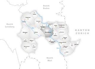
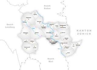
Бремгартен (Bremgarten District, Bezirk Bremgarten)

 Hiking in Бремгартен
Hiking in the Bremgarten District, located in the canton of Aargau, Switzerland, offers a wonderful blend of scenic landscapes, rich history, and accessible trails. Here are some highlights and tips for hiking in this beautiful area:
Scenic Trails
-
Aare River Trail: This trail follows the picturesque Aare River, providing stunning views of the water and surrounding nature. The path is well-marked and suitable for hikers of all levels.
-
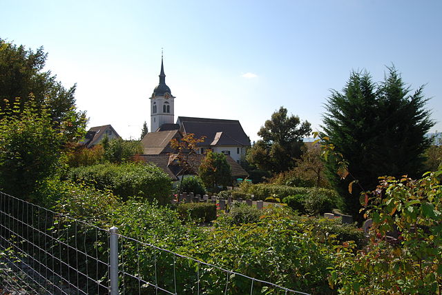
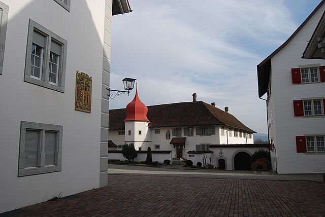
Küsnacht and Bremgarten Trails: There are various local trails that meander through the towns of Küsnacht and Bremgarten, featuring charming medieval architecture, such as the Bremgarten old town, with its traditional buildings and relaxed atmosphere.
-
Nature Reserves: The district is home to numerous natural reserves, like the various forests and meadows around the Aare, ideal for those looking to connect with nature and observe local wildlife.
Hiking Seasons
- Spring and Summer: These are the best seasons for hiking, with blooming flora and pleasant weather enhancing the beauty of the trails.
- Autumn: The fall colors make the landscapes particularly stunning, and the cooler temperatures are perfect for hiking.
- Winter: While some trails may be less accessible, winter hiking can offer a peaceful experience with fewer crowds, especially if you're well-prepared for colder conditions.
Tips for Hikers
- Trail Maps: Always carry a detailed map or use a reliable hiking app to navigate the trails. The Aargau hiking network is well-signposted, but it’s good to have a backup.
- Local Regulations: Respect nature and follow local regulations regarding trail use, wildlife, and land access.
- Hydration and Snacks: Bring enough water and snacks, especially if you plan to hike longer routes.
- Footwear: Wear appropriate hiking shoes to ensure comfort and safety on varying terrains.
Transportation
Bremgarten District is accessible via public transportation, including trains and buses, making it easy to reach popular hiking spots. The local transport system is efficient, allowing you to plan hikes that start and end at different locations.
Points of Interest
- Bremgarten's Old Town: After your hike, take time to explore the charming streets and enjoy local cafes and restaurants.
- Historical Sites: Look out for historical landmarks along the trails, adding a cultural element to your outdoor adventure.
Overall, the Bremgarten District is a fantastic choice for hikers of all skill levels, offering beautiful views, diverse trails, and a welcoming atmosphere. Always check local conditions and trail information before heading out. Enjoy your hike!
- Страна:

- Столица: Бремгартен
- Код автомобильного номера: AG
- Координаты: 47° 21' 0" N, 8° 20' 0" E


- GPS треки (wikiloc): [Ссылка]
- Высота над уровнем моря: 384 м m
- Площадь: 117.46 кв.км
- Википедия русская: wiki(ru)
- Википедия английская: wiki(en)
- Википедия национальная: wiki(de)
- Хранилище Wikidata: Wikidata: Q598525
- Катеория в википедии: [Ссылка]
- код Freebase: [/m/040yk7]
- код GeoNames: Альт: [6458774]
- идентификатор местоположения ArchINFORM: [43363]
Включает регионы:

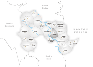
Бремгартен
Hiking in Бремгартен
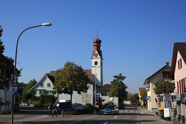
Bremgarten, located in the Aargau region of Switzerland, is a picturesque town that offers a variety of hiking opportunities for outdoor enthusiasts. Nestled along the Reuss River, Bremgarten not only boasts scenic views but also a charming old town full of historical architecture....
- Страна:
- Почтовый код: 5620
- Телефонный код: 056
- Код автомобильного номера: AG
- Координаты: 47° 21' 10" N, 8° 20' 24" E
- GPS треки (wikiloc): [Ссылка]
- Высота над уровнем моря: 386 м m
- Площадь: 11.36 кв.км
- Население: 7765
- Веб сайт: [Ссылка]

Цуфикон
Hiking in Цуфикон
Zufikon, located in the canton of Aargau in Switzerland, offers beautiful landscapes and a variety of hiking opportunities. It is situated near the Limmat River and surrounded by lush fields and rolling hills, making it a perfect destination for outdoor enthusiasts....
- Страна:
- Почтовый код: 5621
- Телефонный код: 056
- Код автомобильного номера: AG
- Координаты: 47° 20' 41" N, 8° 21' 30" E
- GPS треки (wikiloc): [Ссылка]
- Высота над уровнем моря: 401 м m
- Площадь: 4.80 кв.км
- Население: 4450
- Веб сайт: [Ссылка]


Фильмерген
Hiking in Фильмерген
Villmergen, located in the Aargau region of Switzerland, offers a beautiful setting for hiking enthusiasts. While it's a small municipality, it provides access to scenic trails that showcase the charming landscapes of the Swiss countryside....
- Страна:
- Почтовый код: 5612
- Телефонный код: 056
- Код автомобильного номера: AG
- Координаты: 47° 21' 4" N, 8° 14' 28" E
- GPS треки (wikiloc): [Ссылка]
- Высота над уровнем моря: 433 м m
- Площадь: 11.94 кв.км
- Население: 7341
- Веб сайт: [Ссылка]
Оберлункхофен
Hiking in Оберлункхофен
Oberlunkhofen is a small village located in Switzerland, surrounded by beautiful natural landscapes that make it a great spot for hiking enthusiasts. The area features a mix of rolling hills, forests, and picturesque views of the Swiss countryside, making it ideal for various levels of hiking experiences....
- Страна:
- Почтовый код: 8917
- Телефонный код: 056
- Код автомобильного номера: AG
- Координаты: 47° 18' 45" N, 8° 23' 52" E
- GPS треки (wikiloc): [Ссылка]
- Высота над уровнем моря: 488 м m
- Площадь: 3.25 кв.км
- Население: 2012
- Веб сайт: [Ссылка]

Рудольфштеттен-Фридлисберг
Hiking in Рудольфштеттен-Фридлисберг
Rudolfstetten-Friedlisberg is a picturesque municipality located in the Canton of Aargau in Switzerland. This area offers a variety of hiking opportunities, showcasing beautiful landscapes, lush forests, and stunning views of the surrounding hills and valleys....
- Страна:
- Почтовый код: 8964
- Телефонный код: 056
- Код автомобильного номера: AG
- Координаты: 47° 22' 9" N, 8° 22' 55" E
- GPS треки (wikiloc): [Ссылка]
- Высота над уровнем моря: 479 м m
- Площадь: 4.90 кв.км
- Население: 4466
- Веб сайт: [Ссылка]


Арни
Hiking in Арни
Arni, located in the canton of Aargau, Switzerland, is known for its beautiful landscapes and offers a variety of hiking opportunities suitable for different skill levels. Here are some aspects to consider for hiking in and around Arni:...
- Страна:
- Почтовый код: 8905
- Телефонный код: 056
- Код автомобильного номера: AG
- Координаты: 47° 19' 9" N, 8° 25' 20" E
- GPS треки (wikiloc): [Ссылка]
- Высота над уровнем моря: 568 м m
- Площадь: 3.37 кв.км
- Население: 1867
- Веб сайт: [Ссылка]


Берикон
Hiking in Берикон
Berikon is a picturesque town located in the canton of Aargau, Switzerland, and it offers a variety of hiking opportunities that appeal to both casual walkers and more experienced hikers. Here are some key points to consider when hiking in and around Berikon:...
- Страна:
- Почтовый код: 8965
- Телефонный код: 056
- Код автомобильного номера: AG
- Координаты: 47° 21' 14" N, 8° 23' 1" E
- GPS треки (wikiloc): [Ссылка]
- Высота над уровнем моря: 583 м m
- Площадь: 5.38 кв.км
- Население: 4715
- Веб сайт: [Ссылка]


Виден
Hiking in Виден
Widen, located in the Canton of Aargau in Switzerland, offers beautiful hiking opportunities with its picturesque landscapes and well-marked trails. Here are some details to consider when planning a hike in Widen:...
- Страна:
- Почтовый код: 8967
- Телефонный код: 056
- Код автомобильного номера: AG
- Координаты: 47° 22' 12" N, 8° 21' 29" E
- GPS треки (wikiloc): [Ссылка]
- Высота над уровнем моря: 562 м m
- Площадь: 2.62 кв.км
- Население: 3668
- Веб сайт: [Ссылка]


Доттикон
Hiking in Доттикон
Dottikon is a charming village located in the canton of Aargau, Switzerland. It sits at the foot of the Jura Mountains, providing access to beautiful hiking trails and scenic landscapes typical of this region. Here’s what you should know about hiking in and around Dottikon:...
- Страна:
- Почтовый код: 5605
- Телефонный код: 056
- Код автомобильного номера: AG
- Координаты: 47° 22' 50" N, 8° 14' 33" E
- GPS треки (wikiloc): [Ссылка]
- Высота над уровнем моря: 405 м m
- Площадь: 3.89 кв.км
- Население: 3873
- Веб сайт: [Ссылка]

Бюттикон
Hiking in Бюттикон
Büttikon is a charming village located in the canton of Aargau, Switzerland, surrounded by beautiful landscapes and rolling hills, making it a lovely destination for hiking enthusiasts. Here are some details about hiking in and around Büttikon:...
- Страна:
- Почтовый код: 5619
- Телефонный код: 056
- Код автомобильного номера: AG
- Координаты: 47° 19' 42" N, 8° 16' 6" E
- GPS треки (wikiloc): [Ссылка]
- Высота над уровнем моря: 504 м m
- Площадь: 2.82 кв.км
- Население: 981
- Веб сайт: [Ссылка]

Ислисберг
Hiking in Ислисберг
Islisberg is a charming village located in Switzerland, near the city of Zug. It offers beautiful hiking opportunities, surrounded by picturesque landscapes, lush forests, and panoramic views of the surrounding mountains and Lake Zug. Here are some key points to consider when hiking in Islisberg:...
- Страна:
- Почтовый код: 8905
- Телефонный код: 056
- Код автомобильного номера: AG
- Координаты: 47° 19' 24" N, 8° 26' 28" E
- GPS треки (wikiloc): [Ссылка]
- Высота над уровнем моря: 673 м m
- Площадь: 1.65 кв.км
- Население: 618
- Веб сайт: [Ссылка]


Фишбах-Гёсликон
Hiking in Фишбах-Гёсликон
Fischbach-Göslikon is a charming municipality located in the Canton of Aargau, Switzerland, surrounded by lush landscapes and picturesque views. It offers several hiking opportunities that cater to various skill levels and preferences. Here are some key points to consider when planning a hike in Fischbach-Göslikon:...
- Страна:
- Почтовый код: 5525
- Телефонный код: 056
- Код автомобильного номера: AG
- Координаты: 47° 22' 19" N, 8° 18' 25" E
- GPS треки (wikiloc): [Ссылка]
- Высота над уровнем моря: 380 м m
- Площадь: 3.07 кв.км
- Население: 1650
- Веб сайт: [Ссылка]


Йонен
Hiking in Йонен
Jonen, known for its picturesque landscapes and hiking opportunities, is a great destination for outdoor enthusiasts in Switzerland. Located in the canton of Aargau, it offers scenic trails that cater to various skill levels, making it suitable for families, casual walkers, and seasoned hikers alike....
- Страна:
- Почтовый код: 8916
- Телефонный код: 056
- Код автомобильного номера: AG
- Координаты: 47° 17' 54" N, 8° 23' 50" E
- GPS треки (wikiloc): [Ссылка]
- Высота над уровнем моря: 446 м m
- Площадь: 5.70 кв.км
- Население: 2061
- Веб сайт: [Ссылка]


Унтерлункхофен
Hiking in Унтерлункхофен
Unterlunkhofen is a quaint village located in Switzerland, nestled in the scenic region of Canton Aargau. The area around Unterlunkhofen offers some beautiful hiking opportunities, where you can enjoy the lush landscapes and picturesque views of the Swiss countryside....
- Страна:
- Почтовый код: 8918
- Телефонный код: 056
- Код автомобильного номера: AG
- Координаты: 47° 19' 29" N, 8° 22' 59" E
- GPS треки (wikiloc): [Ссылка]
- Высота над уровнем моря: 454 м m
- Площадь: 4.49 кв.км
- Население: 1383
- Веб сайт: [Ссылка]


Тегериг
Hiking in Тегериг
Tägerig, located in the canton of Aargau in Switzerland, offers a variety of hiking opportunities that cater to different skill levels and preferences. The region is characterized by its beautiful landscapes, rolling hills, forests, and views of the nearby mountains. Here's an overview of what you can expect when hiking in Tägerig:...
- Страна:
- Почтовый код: 5522
- Телефонный код: 056
- Код автомобильного номера: AG
- Координаты: 47° 24' 14" N, 8° 16' 50" E
- GPS треки (wikiloc): [Ссылка]
- Высота над уровнем моря: 418 м m
- Площадь: 3.30 кв.км
- Население: 1521
- Веб сайт: [Ссылка]


Ицвиль
Hiking in Ицвиль
Uezwil, located in the Aargau region of Switzerland, offers beautiful landscapes and several hiking opportunities. While it may not be as well-known as some of the larger hiking destinations in Switzerland, it provides a charming and serene experience in nature, often featuring rolling hills, forests, and scenic views....
- Страна:
- Почтовый код: 5619
- Телефонный код: 056
- Код автомобильного номера: AG
- Координаты: 47° 18' 54" N, 8° 16' 40" E
- GPS треки (wikiloc): [Ссылка]
- Высота над уровнем моря: 536 м m
- Площадь: 2.44 кв.км
- Население: 473
- Веб сайт: [Ссылка]
Хермечвиль-Штаффельн
Hiking in Хермечвиль-Штаффельн
Hermetschwil-Staffeln is a picturesque region located in the canton of Aargau, Switzerland. It's known for its stunning natural landscapes, rolling hills, and serene lakeside views, making it an excellent destination for hiking enthusiasts. Here are some key highlights and tips for hiking in this area:...
- Страна:
- Почтовый код: 5626
- Телефонный код: 056
- Код автомобильного номера: AG
- Координаты: 47° 19' 59" N, 8° 20' 50" E
- GPS треки (wikiloc): [Ссылка]
- Высота над уровнем моря: 404 м m
- Веб сайт: [Ссылка]


Зарменсторф
Hiking in Зарменсторф
Sarmenstorf is a charming village located in the canton of Aargau in Switzerland. The area surrounding Sarmenstorf offers beautiful landscapes and several hiking opportunities for outdoor enthusiasts. Here's what you can expect when hiking in and around Sarmenstorf:...
- Страна:
- Почтовый код: 5614
- Телефонный код: 056
- Код автомобильного номера: AG
- Координаты: 47° 18' 41" N, 8° 15' 10" E
- GPS треки (wikiloc): [Ссылка]
- Высота над уровнем моря: 551 м m
- Площадь: 8.30 кв.км
- Население: 2864
- Веб сайт: [Ссылка]


Хеглинген
Hiking in Хеглинген
Hägglingen is a lovely area located in Switzerland, known for its beautiful landscapes and a variety of hiking trails suitable for all skill levels. Situated near the city of Aarau, it offers both scenic views and a peaceful natural environment....
- Страна:
- Почтовый код: 5607
- Телефонный код: 056
- Код автомобильного номера: AG
- Координаты: 47° 23' 24" N, 8° 15' 30" E
- GPS треки (wikiloc): [Ссылка]
- Высота над уровнем моря: 473 м m
- Площадь: 7.73 кв.км
- Население: 2421
- Веб сайт: [Ссылка]


Обервиль-Лили
Hiking in Обервиль-Лили
Oberwil-Lieli is a charming municipality in the canton of Aargau, Switzerland, known for its beautiful landscapes and outdoor recreational opportunities, including hiking. Here are some aspects to consider when hiking in and around Oberwil-Lieli:...
- Страна:
- Почтовый код: 8966
- Телефонный код: 056
- Код автомобильного номера: AG
- Координаты: 47° 20' 0" N, 8° 23' 0" E
- GPS треки (wikiloc): [Ссылка]
- Высота над уровнем моря: 565 м m
- Площадь: 5.35 кв.км
- Население: 2363
- Веб сайт: [Ссылка]

Нидервиль
Hiking in Нидервиль
Niederwil, located in the Aargau region of Switzerland, offers several scenic hiking opportunities that showcase the beautiful landscapes of the area. The region features rolling hills, lush forests, and picturesque agricultural lands, making it ideal for both casual walkers and more experienced hikers....
- Страна:
- Почтовый код: 5524
- Телефонный код: 056
- Код автомобильного номера: AG
- Координаты: 47° 22' 49" N, 8° 17' 50" E
- GPS треки (wikiloc): [Ссылка]
- Высота над уровнем моря: 405 м m
- Площадь: 6.15 кв.км
- Население: 2840
- Веб сайт: [Ссылка]


Эггенвиль
Hiking in Эггенвиль
Eggenwil, located in the canton of Aargau in Switzerland, offers a variety of beautiful hiking opportunities that highlight the area's natural beauty and picturesque landscapes. Here are some key aspects to consider if you're planning a hike in Eggenwil:...
- Страна:
- Почтовый код: 5445
- Телефонный код: 056
- Код автомобильного номера: AG
- Координаты: 47° 22' 14" N, 8° 20' 25" E
- GPS треки (wikiloc): [Ссылка]
- Высота над уровнем моря: 383 м m
- Площадь: 2.46 кв.км
- Население: 1006
- Веб сайт: [Ссылка]


Волен
Hiking in Волен
Wohlen, located in the Aargau canton of Switzerland, offers a variety of hiking opportunities amidst picturesque landscapes and charming rural scenery. The region is characterized by rolling hills, lush meadows, and forests, making it a great destination for both casual walkers and more experienced hikers. Here are some highlights for hiking in Wohlen:...
- Страна:
- Почтовый код: 5610
- Телефонный код: 056
- Код автомобильного номера: AG
- Координаты: 47° 21' 2" N, 8° 16' 40" E
- GPS треки (wikiloc): [Ссылка]
- Высота над уровнем моря: 420 м m
- Площадь: 12.4 кв.км
- Население: 16078
- Веб сайт: [Ссылка]