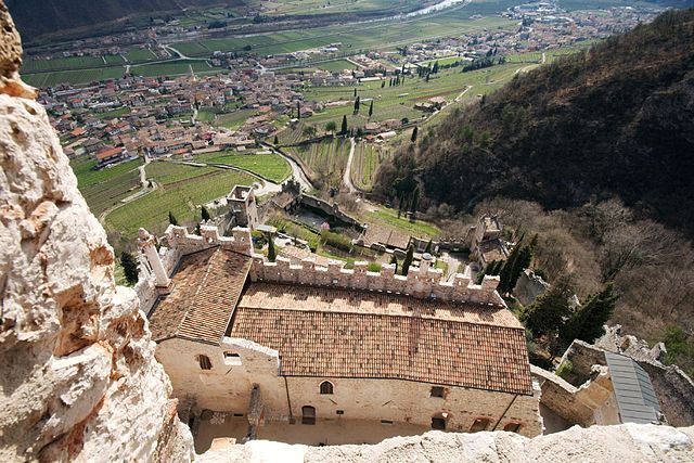
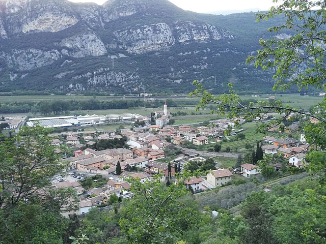
Брентино-Беллуно (Brentino Belluno, Brentino Belluno)
.svg)
- коммуна Италии
 Hiking in Брентино-Беллуно
Brentino Belluno is a picturesque area located in the Veneto region of Italy, nestled in the foothills of the Alps, making it a fantastic destination for hiking enthusiasts. The region is characterized by its stunning landscapes, including rolling hills, lush forests, and breathtaking mountain views.
Hiking Trails and Routes
-
Monte Baldo: The nearby Monte Baldo offers a range of trails with varying difficulty levels. You can enjoy panoramic views of Lake Garda and the surrounding mountains. The trails are well-marked and suitable for different experience levels.
-
Sentiero dei Pescatori: This scenic trail follows the Adige River and provides beautiful views of the riverbanks and surrounding nature. It's an easier hike, making it ideal for families and those looking for a leisurely strolling experience.
-
Valley of the Brenta River: Explore the trails that run along the Brenta River, which offer both challenging hikes and gentler paths. The area is rich in flora and fauna, perfect for nature lovers and bird watchers.
-
Cima Capi and the Bregenz Forest: For a more strenuous hike, you can tackle the trails leading to Cima Capi. The views from the top are worth the effort, and the area is rich in history with remnants of World War I fortifications.
Tips for Hiking in Brentino Belluno
- Season: The best time for hiking is typically from late spring to early autumn (May to September) when the weather is mild and the trails are accessible.
- Gear: Wear appropriate hiking footwear, and bring plenty of water, snacks, and a map or GPS device. Sunscreen and a hat are advisable during the summer months.
- Wildlife: Keep an eye out for local wildlife, including various bird species and small mammals.
- Safety: Always inform someone of your hiking plans, especially if you’re venturing into more remote areas. Carry a basic first-aid kit and know your limits.
Local Culture and Amenities
Brentino Belluno has a rich cultural heritage. Be sure to take time to explore the local villages, enjoy traditional Italian cuisine, and experience the warm hospitality of the locals. There are various accommodations available, ranging from hotels and guesthouses to campsites, catering to different budgets.
Overall, hiking in Brentino Belluno can be a rewarding experience for those who appreciate nature, picturesque landscapes, and the chance to explore the diverse trails the area has to offer.
- Страна:

- Почтовый код: 37020
- Телефонный код: 045
- Код автомобильного номера: VR
- Координаты: 45° 39' 0" N, 10° 54' 0" E


- GPS треки (wikiloc): [Ссылка]
- Высота над уровнем моря: 137 м m
- Площадь: 25.99 кв.км
- Население: 1378
- Веб сайт: http://www.comune.brentino.vr.it/
- Википедия русская: wiki(ru)
- Википедия английская: wiki(en)
- Википедия национальная: wiki(it)
- Хранилище Wikidata: Wikidata: Q46274
- Катеория в википедии: [Ссылка]
- код Freebase: [/m/0gb1wc]
- код GeoNames: Альт: [6542646]
- ID отношения в OpenStreetMap: [45516]
- UN/LOCODE: [ITVE2]
- код Цифрового атласа Римской империи: [17149]
- код ISTAT: 023013
- кадастровый код Италии: B152
Граничит с регионами:

Авио
- коммуна Италии
Hiking in Авио
Avio, located in the province of Trentino in northern Italy, is a fantastic destination for hiking enthusiasts. Nestled in the picturesque Adige Valley, it offers a variety of trails that cater to different skill levels, all while surrounded by breathtaking landscapes that feature mountains, vineyards, and historical sites....
- Страна:
- Почтовый код: 38063
- Телефонный код: 0464
- Код автомобильного номера: TN
- Координаты: 45° 44' 0" N, 10° 57' 0" E
- GPS треки (wikiloc): [Ссылка]
- Высота над уровнем моря: 131 м m
- Площадь: 68.9 кв.км
- Население: 4091
- Веб сайт: [Ссылка]


Каприно-Веронезе
- коммуна Италии
Hiking in Каприно-Веронезе
Caprino Veronese is a charming town located in the province of Verona in northern Italy, nestled at the foot of Monte Baldo. This area is renowned for its stunning natural beauty, diverse landscapes, and numerous hiking trails suitable for all levels of experience. Here are some highlights and tips for hiking in Caprino Veronese:...
- Страна:
- Почтовый код: 37010; 37013
- Телефонный код: 045
- Код автомобильного номера: VR
- Координаты: 45° 36' 0" N, 10° 48' 0" E
- GPS треки (wikiloc): [Ссылка]
- Высота над уровнем моря: 254 м m
- Площадь: 47.32 кв.км
- Население: 8399
- Веб сайт: [Ссылка]
Феррара-ди-Монте-Бальдо
- коммуна Италии
Hiking in Феррара-ди-Монте-Бальдо
Ferrara di Monte Baldo is a charming village situated on the eastern side of Monte Baldo, close to Lake Garda in northern Italy. Known for its stunning natural scenery, diverse flora and fauna, and panoramic views, it’s an excellent destination for hikers of all skill levels. Here’s an overview of what you can expect when hiking in this region....
- Страна:
- Почтовый код: 37020
- Телефонный код: 045
- Код автомобильного номера: VR
- Координаты: 45° 40' 25" N, 10° 51' 39" E
- GPS треки (wikiloc): [Ссылка]
- Высота над уровнем моря: 856 м m
- Площадь: 27 кв.км
- Население: 273
- Веб сайт: [Ссылка]

Дольче
- коммуна Италии
Hiking in Дольче
Dolcè is a small village located in the province of Verona, Italy, nestled in the beautiful surroundings of the Lessinia Regional Park. This area is characterized by its stunning landscapes, charming rural architecture, and a variety of hiking trails that cater to different skill levels. Here are some key points about hiking in Dolcè:...
- Страна:
- Почтовый код: 37020
- Телефонный код: 045
- Код автомобильного номера: VR
- Координаты: 45° 36' 0" N, 10° 51' 0" E
- GPS треки (wikiloc): [Ссылка]
- Высота над уровнем моря: 115 м m
- Площадь: 30.95 кв.км
- Население: 2575
- Веб сайт: [Ссылка]


Риволи-Веронезе
- коммуна Италии
Hiking in Риволи-Веронезе
Rivoli Veronese, located in the province of Verona in northern Italy, offers a charming mix of natural beauty and historical significance, making it an excellent destination for hiking. Nestled within the picturesque landscape of the Lessinia Regional Park, the area features a variety of trails that cater to different skill levels....
- Страна:
- Почтовый код: 37010
- Телефонный код: 045
- Код автомобильного номера: VR
- Координаты: 45° 34' 0" N, 10° 49' 0" E
- GPS треки (wikiloc): [Ссылка]
- Высота над уровнем моря: 191 м m
- Площадь: 18.43 кв.км
- Население: 2210
- Веб сайт: [Ссылка]