.jpg)
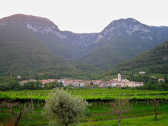
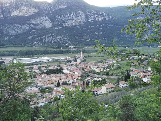
Авио (Avio, Avio)
%202018.svg)
- коммуна Италии
 Hiking in Авио
Avio, located in the province of Trentino in northern Italy, is a fantastic destination for hiking enthusiasts. Nestled in the picturesque Adige Valley, it offers a variety of trails that cater to different skill levels, all while surrounded by breathtaking landscapes that feature mountains, vineyards, and historical sites.
Hiking Trails
-
Sentiero delle Sorgenti: This is a beautiful trail that takes you through lush green areas and leads to the source of the Adige River. It's a moderate hike, perfect for families and those looking to enjoy nature without strenuous climbs.
-
Monte Baldo: Just a short distance from Avio, Monte Baldo offers a variety of hiking routes with stunning views of Lake Garda and the surrounding region. The trails range from easy to difficult, so you can choose one that matches your fitness level. The area is also known for its flora and fauna.
-
The Senter de la Tofana: This moderate trail takes you through the forests and offers views of the Adige Valley. It’s a great choice for those looking to explore the woodland areas around Avio.
-
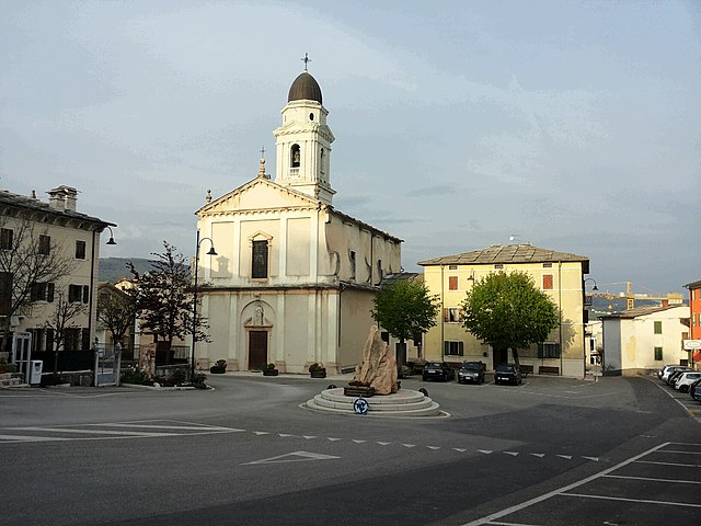
Castel di Avio: For those interested in history, a hike to the nearby Avio Castle is a great option. The route offers a combination of light hiking and cultural exploration, as the castle dates back to the medieval period and provides a fascinating glimpse into the region's history.
Best Time to Hike
The best time for hiking in Avio is typically from late spring (May) to early autumn (September) when the weather is more favorable. During this time, you can expect mild temperatures and a vibrant natural environment.
Required Preparations
- Footwear: Good trekking shoes or boots are recommended as many trails can be rocky or uneven.
- Water and Snacks: Always carry enough water and nutritious snacks, especially for longer hikes.
- Weather: Check the weather forecast before you head out, as conditions can change rapidly in the mountains.
- Maps/GPS: While many trails are well marked, it’s always wise to have a physical map or GPS device for navigation.
Local Advice
Engaging with local hiking groups or guides can enhance your experience, as they often have in-depth knowledge of the area and can share insights about the trails and local flora and fauna. Additionally, consider trying some local cuisine after your hike to experience the culinary delights of the Trentino region.
Hiking in Avio presents a unique blend of natural beauty, culture, and history, making it a rewarding experience for both seasoned hikers and casual walkers.
- Страна:

- Почтовый код: 38063
- Телефонный код: 0464
- Код автомобильного номера: TN
- Координаты: 45° 44' 0" N, 10° 57' 0" E


- GPS треки (wikiloc): [Ссылка]
- Высота над уровнем моря: 131 м m
- Площадь: 68.9 кв.км
- Население: 4091
- Веб сайт: http://www.comune.avio.tn.it/
- Википедия русская: wiki(ru)
- Википедия английская: wiki(en)
- Википедия национальная: wiki(it)
- Хранилище Wikidata: Wikidata: Q243944
- Катеория в википедии: [Ссылка]
- код Freebase: [/m/0g2ggj]
- код GeoNames: Альт: [6537243]
- код VIAF: Альт: [158068529]
- ID отношения в OpenStreetMap: [45755]
- место в MusicBrainz: [08439400-26bf-42e1-8244-3467da8654e9]
- UN/LOCODE: [ITAV7]
- код ISTAT: 022007
- кадастровый код Италии: A520
Граничит с регионами:


Ала
- коммуна Италии
Hiking in Ала
Ala, located in the Trentino region of northern Italy, is a great base for hiking enthusiasts. Nestled in the Vallagarina valley, it offers a variety of trails that range from easy walks to more challenging hikes, all set against the backdrop of stunning landscapes, vineyards, and historical sites....
- Страна:
- Почтовый код: 38061
- Телефонный код: 0464
- Код автомобильного номера: TN
- Координаты: 45° 45' 0" N, 11° 0' 0" E
- GPS треки (wikiloc): [Ссылка]
- Высота над уровнем моря: 210 м m
- Площадь: 119.87 кв.км
- Население: 8887
- Веб сайт: [Ссылка]


Брентонико
- коммуна Италии
Hiking in Брентонико
Brentonico is a charming area located in the Trentino region of northern Italy, known for its stunning landscapes, natural beauty, and an array of hiking opportunities. Nestled on the eastern side of Lake Garda, Brentonico offers a diverse range of trails that cater to different skill levels, making it an ideal spot for both beginner and experienced hikers....
- Страна:
- Почтовый код: 38060
- Телефонный код: 0464
- Код автомобильного номера: TN
- Координаты: 45° 49' 0" N, 10° 57' 0" E
- GPS треки (wikiloc): [Ссылка]
- Высота над уровнем моря: 698 м m
- Площадь: 57.14 кв.км
- Население: 3961
- Веб сайт: [Ссылка]

Брентино-Беллуно
- коммуна Италии
Hiking in Брентино-Беллуно
Brentino Belluno is a picturesque area located in the Veneto region of Italy, nestled in the foothills of the Alps, making it a fantastic destination for hiking enthusiasts. The region is characterized by its stunning landscapes, including rolling hills, lush forests, and breathtaking mountain views....
- Страна:
- Почтовый код: 37020
- Телефонный код: 045
- Код автомобильного номера: VR
- Координаты: 45° 39' 0" N, 10° 54' 0" E
- GPS треки (wikiloc): [Ссылка]
- Высота над уровнем моря: 137 м m
- Площадь: 25.99 кв.км
- Население: 1378
- Веб сайт: [Ссылка]
Феррара-ди-Монте-Бальдо
- коммуна Италии
Hiking in Феррара-ди-Монте-Бальдо
Ferrara di Monte Baldo is a charming village situated on the eastern side of Monte Baldo, close to Lake Garda in northern Italy. Known for its stunning natural scenery, diverse flora and fauna, and panoramic views, it’s an excellent destination for hikers of all skill levels. Here’s an overview of what you can expect when hiking in this region....
- Страна:
- Почтовый код: 37020
- Телефонный код: 045
- Код автомобильного номера: VR
- Координаты: 45° 40' 25" N, 10° 51' 39" E
- GPS треки (wikiloc): [Ссылка]
- Высота над уровнем моря: 856 м m
- Площадь: 27 кв.км
- Население: 273
- Веб сайт: [Ссылка]

Сант'Анна-д'Альфаедо
- коммуна Италии
Hiking in Сант'Анна-д'Альфаедо
Sant'Anna d'Alfaedo is a beautiful village located in the Province of Verona, in the northern Italian region of Veneto. This area is part of the Lessini Mountains, which are known for their stunning landscapes, diverse wildlife, and numerous hiking trails. Here are some key points about hiking in Sant'Anna d'Alfaedo:...
- Страна:
- Почтовый код: 37020
- Телефонный код: 045
- Код автомобильного номера: VR
- Координаты: 45° 38' 0" N, 10° 57' 0" E
- GPS треки (wikiloc): [Ссылка]
- Высота над уровнем моря: 939 м m
- Площадь: 43.43 кв.км
- Население: 2535
- Веб сайт: [Ссылка]

Дольче
- коммуна Италии
Hiking in Дольче
Dolcè is a small village located in the province of Verona, Italy, nestled in the beautiful surroundings of the Lessinia Regional Park. This area is characterized by its stunning landscapes, charming rural architecture, and a variety of hiking trails that cater to different skill levels. Here are some key points about hiking in Dolcè:...
- Страна:
- Почтовый код: 37020
- Телефонный код: 045
- Код автомобильного номера: VR
- Координаты: 45° 36' 0" N, 10° 51' 0" E
- GPS треки (wikiloc): [Ссылка]
- Высота над уровнем моря: 115 м m
- Площадь: 30.95 кв.км
- Население: 2575
- Веб сайт: [Ссылка]


Мальчезине
- коммуна Италии
Hiking in Мальчезине
Malcesine, located on the eastern shore of Lake Garda in Italy, is a stunning destination for hiking enthusiasts. The area is known for its breathtaking landscapes, charming medieval architecture, and a mix of trails suitable for various skill levels. Here are some highlights of hiking in Malcesine:...
- Страна:
- Почтовый код: 37018; 37010
- Телефонный код: 045
- Код автомобильного номера: VR
- Координаты: 45° 46' 0" N, 10° 49' 0" E
- GPS треки (wikiloc): [Ссылка]
- Высота над уровнем моря: 89 м m
- Площадь: 69.29 кв.км
- Население: 3685
- Веб сайт: [Ссылка]