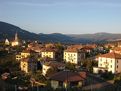
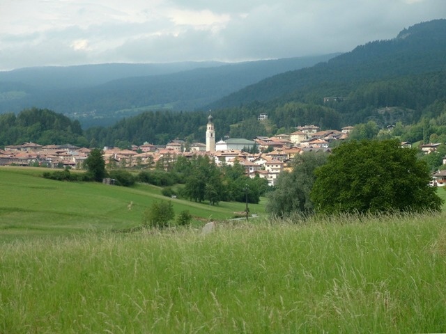
Брец (Brez, Brez)
%202018.svg)
- коммуна Италии
 Hiking in Брец
Brez, located in Slovenia, is a beautiful area known for its natural landscapes, including rolling hills, forests, and picturesque valleys. It offers a variety of hiking trails that cater to different skill levels, making it a great destination for both novice and experienced hikers.
Popular Hiking Trails:
-
The Peca Mountain Trail: This trail offers stunning views of the surrounding area. It features a mix of forested paths and open vistas and is suitable for moderate hikers.
-
The Kamnik-Savinja Alps: For those looking for more challenging hikes, the trails in the nearby Kamnik-Savinja Alps provide breathtaking scenery and a chance to explore the diverse flora and fauna of the region.
-
Brez Mountain Path: A well-marked trail that allows hikers to encounter local wildlife and enjoy the tranquil surroundings.
Tips for Hiking in Brez:
- Proper Gear: Be sure to wear sturdy hiking boots and weather-appropriate clothing. A good backpack with water, snacks, and a map is essential.
- Check Trail Conditions: Before heading out, check local weather conditions and trail status. Loose rocks and mud can make some paths challenging.
- Stay on Marked Trails: To preserve the natural beauty and ensure your safety, stick to marked trails.
- Wildlife Awareness: While hiking, keep an eye out for local wildlife, and remember to respect their habitats.
Best Time to Hike:
- Spring and Fall: These seasons typically provide mild temperatures and fewer crowds, making for a more enjoyable hiking experience.
- Summer: Ideal for high-altitude hikes, but be prepared for warmer temperatures and ensure adequate hydration.
Local Culture:
Hiking in Brez also allows for a deeper appreciation of Slovenian culture, with opportunities to explore small villages, local cuisine, and perhaps some traditional customs, especially at local festivals.
Whether you're looking for a peaceful stroll or an adventurous trek, Brez has trails that can meet your hiking desires while showcasing the beautiful Slovenian landscape.
- Страна:

- Почтовый код: 38021
- Телефонный код: 0463
- Код автомобильного номера: TN
- Координаты: 46° 26' 0" N, 11° 6' 0" E


- GPS треки (wikiloc): [Ссылка]
- Высота над уровнем моря: 792 м m
- Площадь: 19.17 кв.км
- Население: 747
- Веб сайт: http://www.comune.brez.tn.it
- Википедия русская: wiki(ru)
- Википедия английская: wiki(en)
- Википедия национальная: wiki(it)
- Хранилище Wikidata: Wikidata: Q256709
- Катеория в википедии: [Ссылка]
- код Freebase: [/m/0g9y1b]
- код GeoNames: Альт: [6537246]
- ID отношения в OpenStreetMap: [47188]
- код ISTAT: 022027
- кадастровый код Италии: B165
Граничит с регионами:

Дамбель
- коммуна Италии
Hiking in Дамбель
Dambel, located in the beautiful Ethiopian Highlands, offers some amazing hiking opportunities for outdoor enthusiasts. The region is characterized by its stunning landscapes, diverse flora and fauna, and unique cultural experiences. Here are some key points to consider when hiking in Dambel:...
- Страна:
- Почтовый код: 38010
- Телефонный код: 0463
- Код автомобильного номера: TN
- Координаты: 46° 24' 0" N, 11° 6' 0" E
- GPS треки (wikiloc): [Ссылка]
- Высота над уровнем моря: 750 м m
- Площадь: 5.15 кв.км
- Население: 430
- Веб сайт: [Ссылка]
Кастельфондо
- коммуна Италии
Hiking in Кастельфондо
Castelfondo, located in the Trentino region of northern Italy, is a charming village nestled in the heart of the Val di Non. It's an excellent destination for hikers, offering a blend of stunning natural landscapes and cultural experiences....
- Страна:
- Почтовый код: 38020
- Телефонный код: 0463
- Код автомобильного номера: TN
- Координаты: 46° 27' 0" N, 11° 7' 0" E
- GPS треки (wikiloc): [Ссылка]
- Высота над уровнем моря: 948 м m
- Площадь: 25.87 кв.км
- Население: 614
- Веб сайт: [Ссылка]
Клоц
- коммуна Италии
Hiking in Клоц
Cloz, a charming village located in the Trentino region of northern Italy, serves as a gateway to beautiful hikes in the surrounding area. The region is characterized by stunning landscapes, including alpine meadows, forests, and breathtaking mountain views. Here are some key points to consider when planning a hike in and around Cloz:...
- Страна:
- Почтовый код: 38020
- Телефонный код: 0463
- Код автомобильного номера: TN
- Координаты: 46° 25' 0" N, 11° 5' 0" E
- GPS треки (wikiloc): [Ссылка]
- Высота над уровнем моря: 792 м m
- Площадь: 8.21 кв.км
- Население: 676
- Веб сайт: [Ссылка]

Фондо
- коммуна Италии
Hiking in Фондо
Fondo is a picturesque village located in the heart of the Val di Non region in northern Italy. It’s surrounded by stunning landscapes, including mountains, forests, and charming meadows, making it an excellent destination for hiking enthusiasts. Here's what you should know about hiking in Fondo:...
- Страна:
- Почтовый код: 38013
- Телефонный код: 0463
- Код автомобильного номера: TN
- Координаты: 46° 26' 20" N, 11° 8' 14" E
- GPS треки (wikiloc): [Ссылка]
- Высота над уровнем моря: 982 м m
- Площадь: 30.63 кв.км
- Население: 1419
- Веб сайт: [Ссылка]


Сарнонико
- коммуна Италии
Hiking in Сарнонико
Sarnonico, located in the Trentino-Alto Adige region of northern Italy, offers stunning landscapes and a variety of hiking opportunities. It's a charming village nestled in the Non Valley, surrounded by the picturesque mountains of the Brenta Dolomites and the Maddalene Range....
- Страна:
- Почтовый код: 38010
- Телефонный код: 0463
- Код автомобильного номера: TN
- Координаты: 46° 25' 0" N, 11° 9' 0" E
- GPS треки (wikiloc): [Ссылка]
- Высота над уровнем моря: 980 м m
- Площадь: 12.19 кв.км
- Население: 778
- Веб сайт: [Ссылка]


Лауреньо
- коммуна Италии
Hiking in Лауреньо
Laurein, located in the South Tyrol region of northern Italy, offers a unique and picturesque hiking experience. Nestled in the scenic Mendel Pass area, it provides stunning views of the surrounding valleys, mountains, and vineyards. Here are some highlights of hiking in Laurein:...
- Страна:
- Почтовый код: 39040
- Телефонный код: 0463
- Код автомобильного номера: BZ
- Координаты: 46° 27' 16" N, 11° 3' 42" E
- GPS треки (wikiloc): [Ссылка]
- Высота над уровнем моря: 1150 м m
- Площадь: 13.89 кв.км
- Население: 338
- Веб сайт: [Ссылка]