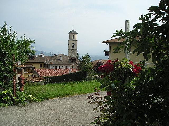
Лауреньо (Laurein, Lauregno)
.svg)
- коммуна Италии
 Hiking in Лауреньо
Laurein, located in the South Tyrol region of northern Italy, offers a unique and picturesque hiking experience. Nestled in the scenic Mendel Pass area, it provides stunning views of the surrounding valleys, mountains, and vineyards. Here are some highlights of hiking in Laurein:
Trails and Routes
- Diverse Terrain: The trails in Laurein range from easy walks to more challenging hikes, accommodating all skill levels. You can find well-marked paths that lead through lush forests, rocky landscapes, and panoramic viewpoints.
- Scenic Views: Many trails offer breathtaking views of the Adige Valley and the South Tyrolean Dolomites. The changing scenery throughout the year enhances the beauty of these hikes.
- Cultural Trails: Some routes combine hiking with exploration of local culture, including paths that lead to historical sites, traditional farms, and charming villages.
Recommended Hikes
- Laurein to the Mendel Pass: A moderate hike that showcases stunning mountain vistas and the beautiful landscape of the surrounding area.
- Views over the Valle di Non: A slightly challenging hike that offers great viewpoints and an opportunity to see the unique fruit orchards of the region.
- Forest Trails: Explore the serene forest paths, ideal for family hikes and leisurely strolls where you can enjoy the tranquility of nature.
Practical Tips
- Best Time to Hike: The best months for hiking in Laurein are typically from late spring to early fall (May to October) when the weather is mild and the trails are accessible.
- Gear Up: Wear proper hiking boots and bring layers of clothing, as temperatures can change quickly in the mountains. Don’t forget essentials like water, snacks, and a map or a hiking app for navigation.
- Local Information: Before heading out, it’s a good idea to check with local tourist information centers for trail conditions, maps, and any guided hike options available.
Getting There
Laurein can be accessed by car or public transportation from larger cities in the region like Bolzano or Merano. It’s advisable to check local bus schedules or car parking options at the hiking trailheads, especially during peak tourist seasons.
Hiking in Laurein is not only an outdoor adventure but also a chance to immerse yourself in the natural beauty and culture of South Tyrol. Enjoy your hike!
- Страна:

- Почтовый код: 39040
- Телефонный код: 0463
- Код автомобильного номера: BZ
- Координаты: 46° 27' 16" N, 11° 3' 42" E


- GPS треки (wikiloc): [Ссылка]
- Высота над уровнем моря: 1150 м m
- Площадь: 13.89 кв.км
- Население: 338
- Веб сайт: http://www.gemeinde.laurein.bz.it
- Википедия русская: wiki(ru)
- Википедия английская: wiki(en)
- Википедия национальная: wiki(it)
- Хранилище Wikidata: Wikidata: Q420432
- Галерея изображений в википедии: [Ссылка]
- Катеория в википедии: [Ссылка]
- код Freebase: [/m/0g9h98]
- код GeoNames: Альт: [6535906]
- код VIAF: Альт: [159651739]
- ID отношения в OpenStreetMap: [47206]
- код GND: Альт: [4099097-7]
- код ISTAT: 021043
- кадастровый код Италии: E481
Граничит с регионами:
Брец
- коммуна Италии
Hiking in Брец
Brez, located in Slovenia, is a beautiful area known for its natural landscapes, including rolling hills, forests, and picturesque valleys. It offers a variety of hiking trails that cater to different skill levels, making it a great destination for both novice and experienced hikers....
- Страна:
- Почтовый код: 38021
- Телефонный код: 0463
- Код автомобильного номера: TN
- Координаты: 46° 26' 0" N, 11° 6' 0" E
- GPS треки (wikiloc): [Ссылка]
- Высота над уровнем моря: 792 м m
- Площадь: 19.17 кв.км
- Население: 747
- Веб сайт: [Ссылка]


Каньйо
- коммуна Италии
Hiking in Каньйо
Cagnò is a small town located in the Trentino-Alto Adige region of northern Italy, known for its beautiful landscapes and proximity to the stunning Dolomites. Hiking in and around Cagnò offers a variety of trails that showcase the natural beauty of the area, including forests, mountains, and views of vineyards and orchards typical of this region....
- Страна:
- Почтовый код: 38028
- Телефонный код: 0463
- Код автомобильного номера: TN
- Координаты: 46° 24' 0" N, 11° 3' 0" E
- GPS треки (wikiloc): [Ссылка]
- Высота над уровнем моря: 670 м m
- Площадь: 3.41 кв.км
- Население: 330
- Веб сайт: [Ссылка]
Кастельфондо
- коммуна Италии
Hiking in Кастельфондо
Castelfondo, located in the Trentino region of northern Italy, is a charming village nestled in the heart of the Val di Non. It's an excellent destination for hikers, offering a blend of stunning natural landscapes and cultural experiences....
- Страна:
- Почтовый код: 38020
- Телефонный код: 0463
- Код автомобильного номера: TN
- Координаты: 46° 27' 0" N, 11° 7' 0" E
- GPS треки (wikiloc): [Ссылка]
- Высота над уровнем моря: 948 м m
- Площадь: 25.87 кв.км
- Население: 614
- Веб сайт: [Ссылка]
Клоц
- коммуна Италии
Hiking in Клоц
Cloz, a charming village located in the Trentino region of northern Italy, serves as a gateway to beautiful hikes in the surrounding area. The region is characterized by stunning landscapes, including alpine meadows, forests, and breathtaking mountain views. Here are some key points to consider when planning a hike in and around Cloz:...
- Страна:
- Почтовый код: 38020
- Телефонный код: 0463
- Код автомобильного номера: TN
- Координаты: 46° 25' 0" N, 11° 5' 0" E
- GPS треки (wikiloc): [Ссылка]
- Высота над уровнем моря: 792 м m
- Площадь: 8.21 кв.км
- Население: 676
- Веб сайт: [Ссылка]

Рево
- коммуна Италии
Hiking in Рево
Revò is a charming village located in the Trentino region of northern Italy, nestled in the heart of the Val di Non. The area is known for its stunning natural beauty, characterized by rolling hills, apple orchards, and the majestic backdrop of the Dolomites. Hiking in Revò offers a variety of trails that cater to different skill levels and preferences....
- Страна:
- Почтовый код: 38028
- Телефонный код: 0463
- Код автомобильного номера: TN
- Координаты: 46° 23' 0" N, 11° 4' 0" E
- GPS треки (wikiloc): [Ссылка]
- Высота над уровнем моря: 729 м m
- Площадь: 13.36 кв.км
- Население: 1278
- Веб сайт: [Ссылка]

Провес
- коммуна в Италии
Hiking in Провес
Proveis, a small village in the Trentino region of Italy, offers some stunning hiking opportunities surrounded by the natural beauty of the Dolomites. Here are some highlights to consider if you're planning to hike in this area:...
- Страна:
- Почтовый код: 39040
- Телефонный код: 0463
- Код автомобильного номера: BZ
- Координаты: 46° 28' 36" N, 11° 1' 21" E
- GPS треки (wikiloc): [Ссылка]
- Высота над уровнем моря: 1420 м m
- Площадь: 18.37 кв.км
- Население: 267
- Веб сайт: [Ссылка]


Ультимо
- коммуна в Италии
Hiking in Ультимо
Hiking in Ulten, which is located in South Tyrol (Südtirol), northern Italy, offers a fantastic experience for outdoor enthusiasts. The region is characterized by its stunning alpine scenery, lush valleys, and a rich diversity of flora and fauna. Here’s what you need to know about hiking in Ulten:...
- Страна:
- Почтовый код: 39016
- Телефонный код: 0473
- Код автомобильного номера: BZ
- Координаты: 46° 32' 54" N, 11° 0' 15" E
- GPS треки (wikiloc): [Ссылка]
- Высота над уровнем моря: 1190 м m
- Площадь: 208.12 кв.км
- Население: 2871
- Веб сайт: [Ссылка]


Сан-Панкрацио
- коммуна в Италии
Hiking in Сан-Панкрацио
St. Pankraz, located in the picturesque region of South Tyrol in Italy, offers a range of hiking opportunities for outdoor enthusiasts of all levels. Here are some key highlights about hiking in St. Pankraz:...
- Страна:
- Почтовый код: 39010
- Телефонный код: 0473
- Код автомобильного номера: BZ
- Координаты: 46° 35' 10" N, 11° 5' 9" E
- GPS треки (wikiloc): [Ссылка]
- Высота над уровнем моря: 735 м m
- Площадь: 63.17 кв.км
- Население: 1549
- Веб сайт: [Ссылка]