Брю-Орьяк (Brue-Auriac, Brue-Auriac)

- коммуна во Франции
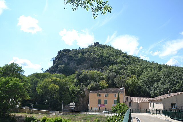
 Hiking in Брю-Орьяк
Brue-Auriac is a charming commune located in the Provence-Alpes-Côte d'Azur region of France, surrounded by beautiful natural landscapes that offer great opportunities for hiking. Here are a few highlights to consider when planning a hiking trip in the area:
Scenic Trails
- Local Walking Routes: The region has various marked hiking trails that wind through the beautiful countryside, featuring vineyards, olive groves, and rolling hills.
- Gorges de la Sainte-Baume: Not far from Brue-Auriac, this area offers stunning gorge views and a variety of hiking paths. The trails range from easy to moderate difficulty, making them suitable for different skill levels.
Flora and Fauna
The region is rich in biodiversity, and hikers can expect to encounter a variety of local flora, including fragrant herbs and wildflowers unique to the Mediterranean climate. Birdwatchers might also enjoy spotting different species in this diverse habitat.
Preparation Tips
- Seasonal Considerations: The best times for hiking in the area are spring (April to June) and fall (September to October) when the weather is generally temperate. Summers can be hot, so early morning hikes are recommended during those months.
- Gear: Wear appropriate footwear, carry enough water, and bring sunscreen and a hat, especially in warmer months.
- Navigation: While many trails are marked, it's useful to have a map or a GPS device to ensure you stay on track.
Local Culture
Don’t forget to immerse yourself in the local culture! After a day of hiking, you can explore the quaint village, taste local wines, and enjoy Provencal cuisine in nearby restaurants.
Conclusion
Brue-Auriac offers a wonderful hiking experience, combining stunning natural landscapes with cultural richness. Whether you're looking for a leisurely stroll or more rigorous trails, you'll find great options in and around this picturesque area! Always remember to follow local guidelines and respect the environment while hiking.
- Страна:

- Почтовый код: 83119
- Координаты: 43° 31' 39" N, 5° 56' 40" E


- GPS треки (wikiloc): [Ссылка]
- Площадь: 36.73 кв.км
- Население: 1322
- Веб сайт: http://www.brue-auriac.fr
- Википедия русская: wiki(ru)
- Википедия английская: wiki(en)
- Википедия национальная: wiki(fr)
- Хранилище Wikidata: Wikidata: Q1154634
- Катеория в википедии: [Ссылка]
- код Freebase: [/m/03qcrzh]
- код GeoNames: Альт: [3029809]
- номер SIREN: [218300259]
- код BNF: [15277852s]
- код тезауруса PACTOLS: [pcrtyyvKQFj11v]
- код TGN: [1032349]
- код муниципалитета INSEE: 83025
Граничит с регионами:


Сен-Мартен-де-Пальер
- коммуна во Франции
Hiking in Сен-Мартен-де-Пальер
Saint-Martin-de-Pallières is a charming commune located in the Var department of the Provence-Alpes-Côte d'Azur region in southeastern France. It's a fantastic location for hiking enthusiasts due to its beautiful natural landscapes, historic sites, and relatively quiet trails. Here are some key points to consider if you plan to hike in this area:...
- Страна:
- Почтовый код: 83560
- Координаты: 43° 35' 19" N, 5° 53' 4" E
- GPS треки (wikiloc): [Ссылка]
- Площадь: 26.33 кв.км
- Население: 248


Баржоль
- коммуна во Франции
Hiking in Баржоль
Barjols, located in the Provence-Alpes-Côte d'Azur region of France, is a charming village renowned for its picturesque landscapes and rich history. The surrounding area offers a variety of hiking opportunities for both beginners and experienced trekkers, along with stunning natural scenery that includes hills, forests, and waterfalls....
- Страна:
- Почтовый код: 83670
- Координаты: 43° 33' 29" N, 6° 0' 27" E
- GPS треки (wikiloc): [Ссылка]
- Площадь: 30.06 кв.км
- Население: 3051
- Веб сайт: [Ссылка]

Шатовер
- коммуна во Франции
Hiking in Шатовер
Châteauvert is a picturesque area located in the Var department of southeastern France, known for its stunning natural landscapes, rich biodiversity, and a variety of outdoor activities, including hiking. Hiking in Châteauvert offers a unique combination of beautiful scenery, including limestone cliffs, lush forests, and rivers, as well as opportunities to explore the region's cultural heritage....
- Страна:
- Почтовый код: 83670
- Координаты: 43° 30' 0" N, 6° 1' 33" E
- GPS треки (wikiloc): [Ссылка]
- Площадь: 27.52 кв.км
- Население: 145
- Веб сайт: [Ссылка]


Сейон-Сурс-д’Аржан
- коммуна во Франции
Hiking in Сейон-Сурс-д’Аржан
Seillons-Source-d'Argens is a charming village located in the Var department of the Provence-Alpes-Côte d'Azur region in southeastern France. The area is known for its beautiful landscapes, rich history, and variety of hiking trails. Here are some highlights for hikers considering a visit:...
- Страна:
- Почтовый код: 83470
- Координаты: 43° 29' 47" N, 5° 53' 1" E
- GPS треки (wikiloc): [Ссылка]
- Высота над уровнем моря: 320 м m
- Площадь: 25.11 кв.км
- Население: 2513
- Веб сайт: [Ссылка]


Брас
- коммуна во Франции
Hiking in Брас
Hiking in Bras, located in the Var department of the Provence-Alpes-Côte d'Azur region in southeastern France, offers a wonderful experience for nature lovers and outdoor enthusiasts. Here are some highlights and tips for hiking in this beautiful area:...
- Страна:
- Почтовый код: 83149
- Координаты: 43° 28' 19" N, 5° 57' 13" E
- GPS треки (wikiloc): [Ссылка]
- Площадь: 34.93 кв.км
- Население: 2675
- Веб сайт: [Ссылка]


Сен-Максимен-ла-Сент-Бом
- коммуна во Франции
Hiking in Сен-Максимен-ла-Сент-Бом
Saint-Maximin-la-Sainte-Baume, located in the Provence-Alpes-Côte d'Azur region of France, is an excellent destination for hiking enthusiasts. The town is beautifully situated near the Sainte-Baume mountain range, which offers a variety of trails and stunning natural landscapes, making it ideal for all levels of hikers....
- Страна:
- Почтовый код: 83470
- Координаты: 43° 27' 12" N, 5° 51' 43" E
- GPS треки (wikiloc): [Ссылка]
- Площадь: 64.13 кв.км
- Население: 16037
- Веб сайт: [Ссылка]