Сен-Максимен-ла-Сент-Бом (Saint-Maximin-la-Sainte-Baume, Saint-Maximin-la-Sainte-Baume)

- коммуна во Франции
 Hiking in Сен-Максимен-ла-Сент-Бом
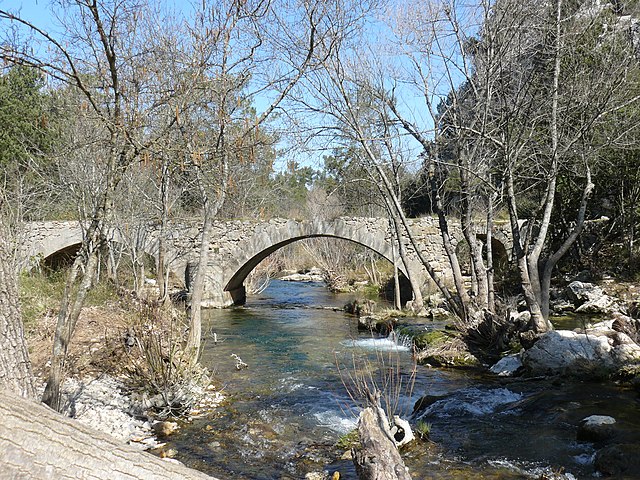
Saint-Maximin-la-Sainte-Baume, located in the Provence-Alpes-Côte d'Azur region of France, is an excellent destination for hiking enthusiasts. The town is beautifully situated near the Sainte-Baume mountain range, which offers a variety of trails and stunning natural landscapes, making it ideal for all levels of hikers.
Key Highlights
-
Sainte-Baume Mountain Range: This range is renowned for its dramatic cliffs, deep gorges, and verdant forests. The area is rich in biodiversity and offers trails that vary in difficulty.
-
Historical Significance: The area is known for its historical and religious significance, particularly the Sainte-Baume cave, where Mary Magdalene is believed to have lived. Some trails lead to sites connected to this history, adding a unique cultural aspect to your hike.
-
Diverse Trails: There are numerous trails that cater to different skill levels, from easy walks suitable for families to more challenging hikes that offer stunning panoramic views. Popular routes include paths through the forest and along the cliffs.
-
Flora and Fauna: Hikers can enjoy the diverse flora, including oak and pine forests, as well as a variety of wildlife. Birdwatchers may also spot several interesting species in the area.
-
Local Amenities: Saint-Maximin-la-Sainte-Baume has several local amenities, including cafés and restaurants, where you can relax after your hike. You can also visit the town’s historical sites.
Practical Tips
-
Best Time to Visit: The best months for hiking are typically late spring to early autumn when the weather is mild and dry. Be cautious of summer heat, especially in the lower areas.
-
Trail Maps: Before setting out, obtain a map of the hiking trails. Local tourist offices can provide valuable information and updated trail conditions.
-
Gear: Wear appropriate hiking shoes and bring plenty of water, especially on longer hikes. A lightweight backpack with snacks, a hat, and sunscreen is also advisable.
-
Safety: Always inform someone of your hiking plans, especially if you’re hiking alone. Some trails might be secluded, and it's wise to have a basic understanding of the terrain.
Overall, hiking in Saint-Maximin-la-Sainte-Baume offers a combination of natural beauty, historical context, and an array of trails suited for different preferences, making it a fantastic spot for outdoor activities in Provence.
- Страна:

- Почтовый код: 83470
- Координаты: 43° 27' 12" N, 5° 51' 43" E


- GPS треки (wikiloc): [Ссылка]
- Площадь: 64.13 кв.км
- Население: 16037
- Веб сайт: http://www.st-maximin.fr/
- Википедия русская: wiki(ru)
- Википедия английская: wiki(en)
- Википедия национальная: wiki(fr)
- Хранилище Wikidata: Wikidata: Q848718
- Катеория в википедии: [Ссылка]
- код Freebase: [/m/03hwxn]
- код Freebase: [/m/03hwxn]
- код GeoNames: Альт: [2978100]
- код GeoNames: Альт: [2978100]
- номер SIREN: [218301166]
- номер SIREN: [218301166]
- код BNF: [152779433]
- код BNF: [152779433]
- код VIAF: Альт: [140801782]
- код VIAF: Альт: [140801782]
- код GND: Альт: [4232971-1]
- код GND: Альт: [4232971-1]
- идентификатор местоположения ArchINFORM: [11378]
- идентификатор местоположения ArchINFORM: [11378]
- код LCNAF: Альт: [n85207864]
- код LCNAF: Альт: [n85207864]
- код тезауруса PACTOLS: [pcrtRVSsUB4LHT]
- код тезауруса PACTOLS: [pcrtRVSsUB4LHT]
- место в MusicBrainz: [35985d48-04fd-4e16-a40b-15a6d10a7d8f]
- место в MusicBrainz: [35985d48-04fd-4e16-a40b-15a6d10a7d8f]
- код SUDOC: [067073646]
- код SUDOC: [067073646]
- EMLO location ID: [fb5e7c80-5106-4a93-a540-25608465572d]
- EMLO location ID: [fb5e7c80-5106-4a93-a540-25608465572d]
- код NKC: [ge924307]
- код NKC: [ge924307]
- код муниципалитета INSEE: 83116
- код муниципалитета INSEE: 83116
Граничит с регионами:

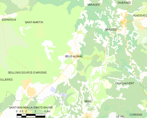
Брю-Орьяк
- коммуна во Франции
Hiking in Брю-Орьяк
Brue-Auriac is a charming commune located in the Provence-Alpes-Côte d'Azur region of France, surrounded by beautiful natural landscapes that offer great opportunities for hiking. Here are a few highlights to consider when planning a hiking trip in the area:...
- Страна:
- Почтовый код: 83119
- Координаты: 43° 31' 39" N, 5° 56' 40" E
- GPS треки (wikiloc): [Ссылка]
- Площадь: 36.73 кв.км
- Население: 1322
- Веб сайт: [Ссылка]


Ружье
- коммуна во Франции
Hiking in Ружье
Rougiers is a small commune located in the Var department in the Provence-Alpes-Côte d'Azur region of southeastern France. It is surrounded by beautiful natural landscapes, making it an excellent spot for hiking enthusiasts. Here's a guide to hiking in the Rougiers area:...
- Страна:
- Почтовый код: 83170
- Координаты: 43° 23' 33" N, 5° 51' 4" E
- GPS треки (wikiloc): [Ссылка]
- Площадь: 20.53 кв.км
- Население: 1623

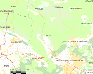
Ольер
- коммуна во Франции
Hiking in Ольер
Ollières is a charming commune located in the Var department of the Provence-Alpes-Côte d'Azur region in southeastern France. The region is known for its rolling hills, picturesque landscapes, and Mediterranean climate, making it a great destination for hiking enthusiasts. Here are some highlights and tips for hiking in Ollières:...
- Страна:
- Почтовый код: 83470
- Координаты: 43° 28' 58" N, 5° 49' 47" E
- GPS треки (wikiloc): [Ссылка]
- Площадь: 39.66 кв.км
- Население: 630


Нан-ле-Пен
- коммуна во Франции
Hiking in Нан-ле-Пен
Nans-les-Pins is a charming village located in the Var department in the Provence-Alpes-Côte d'Azur region of France. It's surrounded by beautiful landscapes, making it a great destination for hiking enthusiasts. Here are some highlights of hiking in and around Nans-les-Pins:...
- Страна:
- Почтовый код: 83860
- Координаты: 43° 22' 14" N, 5° 46' 56" E
- GPS треки (wikiloc): [Ссылка]
- Площадь: 47.99 кв.км
- Население: 4276
- Веб сайт: [Ссылка]


Пурсьё
- коммуна во Франции
Hiking in Пурсьё
Pourcieux is a charming village located in the Provence-Alpes-Côte d'Azur region of France. It offers a variety of hiking opportunities that allow you to explore the stunning natural landscapes of the surrounding areas. Here are some highlights and tips for hiking in Pourcieux:...
- Страна:
- Почтовый код: 83470
- Координаты: 43° 28' 13" N, 5° 47' 11" E
- GPS треки (wikiloc): [Ссылка]
- Площадь: 21.23 кв.км
- Население: 1503


Сейон-Сурс-д’Аржан
- коммуна во Франции
Hiking in Сейон-Сурс-д’Аржан
Seillons-Source-d'Argens is a charming village located in the Var department of the Provence-Alpes-Côte d'Azur region in southeastern France. The area is known for its beautiful landscapes, rich history, and variety of hiking trails. Here are some highlights for hikers considering a visit:...
- Страна:
- Почтовый код: 83470
- Координаты: 43° 29' 47" N, 5° 53' 1" E
- GPS треки (wikiloc): [Ссылка]
- Высота над уровнем моря: 320 м m
- Площадь: 25.11 кв.км
- Население: 2513
- Веб сайт: [Ссылка]

Турв
- коммуна во Франции
Hiking in Турв
Tourves is a charming commune located in the Var department of the Provence-Alpes-Côte d'Azur region in southeastern France. It is surrounded by stunning landscapes, including rolling hills, vineyards, and picturesque countryside, making it an ideal spot for hiking enthusiasts....
- Страна:
- Почтовый код: 83170
- Координаты: 43° 24' 29" N, 5° 55' 26" E
- GPS треки (wikiloc): [Ссылка]
- Площадь: 65.62 кв.км
- Население: 4973


Брас
- коммуна во Франции
Hiking in Брас
Hiking in Bras, located in the Var department of the Provence-Alpes-Côte d'Azur region in southeastern France, offers a wonderful experience for nature lovers and outdoor enthusiasts. Here are some highlights and tips for hiking in this beautiful area:...
- Страна:
- Почтовый код: 83149
- Координаты: 43° 28' 19" N, 5° 57' 13" E
- GPS треки (wikiloc): [Ссылка]
- Площадь: 34.93 кв.км
- Население: 2675
- Веб сайт: [Ссылка]