Брунненталь (Brunnenthal, Brunnenthal)
 Hiking in Брунненталь
Brunnenthal is a charming area located in Austria, known for its picturesque landscapes and outdoor activities. Hiking enthusiasts will find a variety of trails that offer stunning views, lush greenery, and opportunities to explore the natural beauty of the region.
Key Highlights for Hiking in Brunnenthal:
-
Diverse Trails: Brunnenthal offers a range of hiking trails suitable for different skill levels, from easy walks for beginners to more challenging routes for experienced hikers. You can explore through forests, meadows, and along rivers.
-
Scenic Beauty: The landscape is characterized by rolling hills, streams, and panoramic views of the surrounding mountains. The changing seasons add to the beauty, with vibrant colors in autumn and blooming wildflowers in spring.
-
Local Flora and Fauna: As you hike, keep an eye out for local wildlife. The region is rich in biodiversity, including various bird species and unique plant life.
-
Cultural Attractions: Hiking in Brunnenthal isn’t just about nature; you might encounter traditional Austrian farmhouses, historical sites, and local artwork. Some trails may lead you through quaint villages where you can taste regional cuisine.
-
Accessibility: The area is accessible from major Austrian cities, making it a popular choice for day hikes or weekend trips. Local hiking maps and information can often be found through visitor centers or online resources.
-
Safety and Preparation: As with any hike, ensure you're prepared with appropriate gear, sufficient water, and knowledge of the trail conditions. Check local weather forecasts and trail guidelines.
-
Guided Tours: For those unfamiliar with the area, consider joining a guided hiking tour. Local guides can provide insights into the landscape, culture, and history of Brunnenthal.
General Tips:
- Wear Proper Footwear: Sturdy hiking boots are essential for navigating various terrains.
- Stay Hydrated: Always carry enough water, especially during warmer months.
- Respect Nature: Follow Leave No Trace principles; ensure you take your litter with you.
- Trail Maps: Carry a map or download a hiking app to stay on track.
Conclusion:
Hiking in Brunnenthal, Austria, is an enriching experience that combines physical activity with the chance to explore beautiful landscapes and local culture. Whether you're looking for a peaceful walk or an adventurous hike, this region offers something for everyone. Enjoy your hike!
- Страна:

- Почтовый код: 4786
- Телефонный код: 07712
- Код автомобильного номера: SD
- Координаты: 48° 28' 0" N, 13° 28' 0" E


- GPS треки (wikiloc): [Ссылка]
- Высота над уровнем моря: 383 м m
- Площадь: 15 кв.км
- Население: 2032
- Веб сайт: http://www.brunnenthal.at/
- Википедия русская: wiki(ru)
- Википедия английская: wiki(en)
- Википедия национальная: wiki(de)
- Хранилище Wikidata: Wikidata: Q685070
- Катеория в википедии: [Ссылка]
- код Freebase: [/m/03gvbjc]
- код GeoNames: Альт: [7873209]
- код австрийского муниципалитета: [41403]
Граничит с регионами:

Шарденберг
Hiking in Шарденберг
Schardenberg, located in Upper Austria near the Austrian-German border, offers a variety of hiking opportunities that combine beautiful landscapes, rich natural diversity, and cultural experiences. Here are some highlights and tips for hiking in the area:...
- Страна:
- Почтовый код: 4784
- Телефонный код: 07713
- Код автомобильного номера: SD
- Координаты: 48° 31' 13" N, 13° 29' 51" E
- GPS треки (wikiloc): [Ссылка]
- Высота над уровнем моря: 543 м m
- Площадь: 32 кв.км
- Население: 2407
- Веб сайт: [Ссылка]
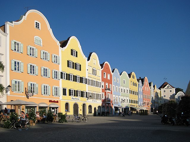
Шердинг
Hiking in Шердинг
Schärding, a picturesque town in Austria located near the border with Germany, is known for its beautiful baroque architecture and scenic landscapes. The surrounding region offers various hiking opportunities that cater to different skill levels and preferences. Here are some highlights of hiking in and around Schärding:...
- Страна:
- Почтовый код: 4780
- Телефонный код: 07712
- Код автомобильного номера: SD
- Координаты: 48° 27' 25" N, 13° 25' 54" E
- GPS треки (wikiloc): [Ссылка]
- Высота над уровнем моря: 313 м m
- Площадь: 3.96 кв.км
- Население: 5253
- Веб сайт: [Ссылка]

Нойхаус-на-Инне
Hiking in Нойхаус-на-Инне
Neuhaus am Inn is a charming town located in Bavaria, Germany, near the border with Austria. Surrounded by beautiful landscapes, it serves as an excellent base for hiking enthusiasts. Here are some highlights and tips to consider when hiking in this area:...
- Страна:

- Почтовый код: 94152
- Телефонный код: 08503
- Код автомобильного номера: PA
- Координаты: 48° 27' 38" N, 13° 25' 13" E
- GPS треки (wikiloc): [Ссылка]
- Высота над уровнем моря: 323 м m
- Площадь: 31.07 кв.км
- Население: 3415
- Веб сайт: [Ссылка]


Вернштайн-на-Инне
Hiking in Вернштайн-на-Инне
Wernstein am Inn is a charming village located in Upper Austria, near the border with Germany. It sits along the banks of the Inn River and is surrounded by picturesque landscapes, making it a great destination for hiking enthusiasts. Here are some details to consider while planning your hiking adventures in the area:...
- Страна:
- Почтовый код: 4783
- Телефонный код: 07713
- Код автомобильного номера: SD
- Координаты: 48° 30' 31" N, 13° 27' 37" E
- GPS треки (wikiloc): [Ссылка]
- Высота над уровнем моря: 319 м m
- Площадь: 16 кв.км
- Население: 1566
- Веб сайт: [Ссылка]

Санкт-Флориан-на-Инне
Hiking in Санкт-Флориан-на-Инне
Sankt Florian am Inn is a picturesque village located in the Innviertel region of Upper Austria, right along the banks of the River Inn. The area is known for its natural beauty, rolling hills, and varied landscapes, making it a fantastic destination for hikers of all levels. Here are some highlights to consider:...
- Страна:
- Почтовый код: 4782
- Код автомобильного номера: SD
- Координаты: 48° 26' 0" N, 13° 36' 0" E
- GPS треки (wikiloc): [Ссылка]
- Высота над уровнем моря: 321 м m
- Площадь: 24 кв.км
- Население: 3150
- Веб сайт: [Ссылка]

Райнбах
Hiking in Райнбах
Rainbach im Innkreis is a charming area located in the Upper Austria region, surrounded by beautiful natural landscapes that are perfect for hiking enthusiasts. The region features rolling hills, lush forests, and scenic views, making it an inviting destination for both casual walkers and experienced trekkers....
- Страна:
- Телефонный код: 07716
- Код автомобильного номера: SD
- Координаты: 48° 27' 0" N, 13° 32' 0" E
- GPS треки (wikiloc): [Ссылка]
- Высота над уровнем моря: 371 м m
- Площадь: 25 кв.км
- Население: 1478
- Веб сайт: [Ссылка]