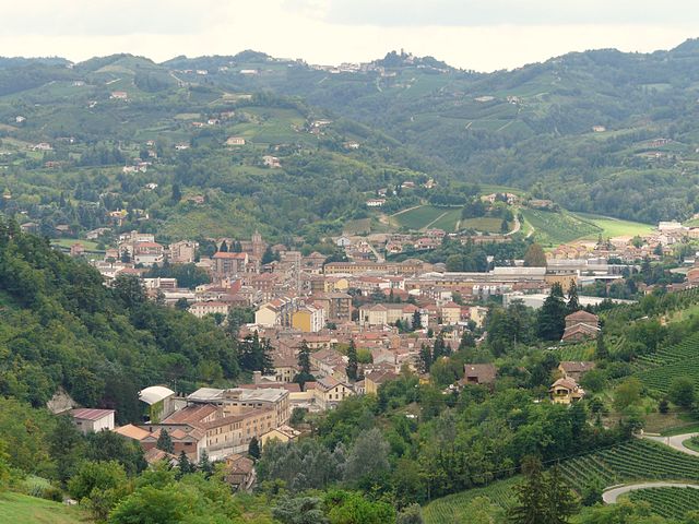
Буббио (Bubbio, Bubbio)

- коммуна Италии
 Hiking in Буббио
Bubbio is a charming village located in the Piedmont region of Italy, nestled in the mountainous landscape of the Langhe and Monferrato areas. Hiking in and around Bubbio offers a delightful mix of natural beauty, cultural heritage, and picturesque views.
Hiking Trails:
-
Sentiero dei Fiumi: This trail takes you through the scenic valleys and alongside rivers, providing stunning views of the surrounding hills and vineyards. It’s suitable for various skill levels.
-
Monte Capanne: A hike to Monte Capanne will reward you with panoramic views of the surrounding countryside, including the vineyards and rolling hills typical of the region. The trail can be more challenging, so it's recommended for experienced hikers.
-
Bubbio to Roccaverano: This moderate trail connects Bubbio to the nearby village of Roccaverano, known for its traditional cheese. The path takes you through forests, past ancient farms, and vibrant fields.
Recommendations:
-
Best Time to Hike: The ideal seasons for hiking are late spring (May to June) and early autumn (September to October) when the weather is mild, and the landscapes are at their most beautiful.
-
What to Bring: As always, it’s essential to wear sturdy hiking shoes and bring enough water, snacks, a map, and possibly trekking poles. A camera is also recommended to capture the stunning views and unique architecture of the area.
-
Local Tips: Take some time to explore the village of Bubbio itself, with its historic buildings, local cuisine, and perhaps enjoy a tasting of the regional wines.
Safety Considerations:
- Always check the weather forecast before heading out.
- Inform someone about your hiking plans and expected return time.
- Stay on marked trails to preserve the environment and ensure your safety.
Hiking in Bubbio not only allows you to experience the beauty of the Italian countryside but also offers a glimpse into the lifestyle and culture of the region. Whether you're an experienced hiker or a beginner, there's something for everyone in this picturesque area.
- Страна:

- Почтовый код: 14051
- Телефонный код: 0144
- Код автомобильного номера: AT
- Координаты: 44° 39' 52" N, 8° 17' 46" E


- GPS треки (wikiloc): [Ссылка]
- Высота над уровнем моря: 224 м m
- Площадь: 15.76 кв.км
- Население: 847
- Веб сайт: http://www.comune.bubbio.at.it
- Википедия русская: wiki(ru)
- Википедия английская: wiki(en)
- Википедия национальная: wiki(it)
- Хранилище Wikidata: Wikidata: Q17757
- Катеория в википедии: [Ссылка]
- код Freebase: [/m/0gbfsn]
- код GeoNames: Альт: [6540951]
- код VIAF: Альт: [244756519]
- ID отношения в OpenStreetMap: [43404]
- WOEID: [711494]
- UN/LOCODE: [ITBUB]
- код ISTAT: 005011
- кадастровый код Италии: B236
Граничит с регионами:

Канелли
- коммуна Италии
Hiking in Канелли
Canelli, located in the Piedmont region of Italy, is known for its beautiful vineyards and rolling hills, making it a great destination for hiking enthusiasts. The area is famous for its wine, particularly Moscato d’Asti and other sparkling wines, which adds a charming backdrop to the hiking experience....
- Страна:
- Почтовый код: 14053
- Телефонный код: 0141
- Код автомобильного номера: AT
- Координаты: 44° 43' 15" N, 8° 17' 34" E
- GPS треки (wikiloc): [Ссылка]
- Высота над уровнем моря: 157 м m
- Площадь: 23.43 кв.км
- Население: 10430
- Веб сайт: [Ссылка]


Кассинаско
- коммуна Италии
Hiking in Кассинаско
Cassinasco is a small village located in the Piedmont region of Italy, nestled within the beautiful hills of the Monferrato area. It's known for its picturesque landscapes, rolling vineyards, and charming rural scenery, making it a delightful destination for hiking enthusiasts....
- Страна:
- Почтовый код: 14050
- Телефонный код: 0141
- Код автомобильного номера: AT
- Координаты: 44° 41' 24" N, 8° 18' 13" E
- GPS треки (wikiloc): [Ссылка]
- Высота над уровнем моря: 447 м m
- Площадь: 11.84 кв.км
- Население: 589
- Веб сайт: [Ссылка]


Чессоле
- коммуна Италии
Hiking in Чессоле
Cessole is a charming village located in the Piedmont region of Italy, within the province of Asti. Surrounded by beautiful vineyards and rolling hills, it offers a variety of hiking opportunities for nature enthusiasts and outdoor adventurers. Here are some key points about hiking in Cessole:...
- Страна:
- Почтовый код: 14050
- Телефонный код: 0144
- Код автомобильного номера: AT
- Координаты: 44° 39' 0" N, 8° 14' 41" E
- GPS треки (wikiloc): [Ссылка]
- Высота над уровнем моря: 280 м m
- Площадь: 11.78 кв.км
- Население: 402
- Веб сайт: [Ссылка]
Лоаццоло
- коммуна Италии
Hiking in Лоаццоло
Loazzolo is a charming municipality located in the Piedmont region of northern Italy, known for its breathtaking landscapes, rolling hills, and vineyards. It is a great destination for hiking enthusiasts who appreciate both natural beauty and cultural heritage....
- Страна:
- Почтовый код: 14050
- Телефонный код: 0144
- Код автомобильного номера: AT
- Координаты: 44° 40' 12" N, 8° 15' 34" E
- GPS треки (wikiloc): [Ссылка]
- Высота над уровнем моря: 430 м m
- Площадь: 14.82 кв.км
- Население: 341
- Веб сайт: [Ссылка]


Монастеро-Бормида
- коммуна Италии
Hiking in Монастеро-Бормида
Monastero Bormida is a charming village located in the Piedmont region of Italy, known for its picturesque landscapes, vineyards, and serene countryside. It is an excellent destination for hiking enthusiasts who wish to explore the beautiful terrain of the area....
- Страна:
- Почтовый код: 14058
- Телефонный код: 0144
- Код автомобильного номера: AT
- Координаты: 44° 38' 58" N, 8° 19' 40" E
- GPS треки (wikiloc): [Ссылка]
- Высота над уровнем моря: 191 м m
- Площадь: 14.21 кв.км
- Население: 934
- Веб сайт: [Ссылка]


Роккаверано
- коммуна Италии
Hiking in Роккаверано
Roccaverano is a charming hilltop village located in the Piedmont region of Italy, known for its scenic landscapes and rich agricultural heritage, particularly its local cheese, Roccaverano cheese. The surrounding area offers a variety of hiking opportunities that allow visitors to explore the beautiful countryside, rolling hills, vineyards, and forests....
- Страна:
- Почтовый код: 14050
- Телефонный код: 0144
- Код автомобильного номера: AT
- Координаты: 44° 35' 36" N, 8° 16' 24" E
- GPS треки (wikiloc): [Ссылка]
- Высота над уровнем моря: 759 м m
- Площадь: 29.98 кв.км
- Население: 396
- Веб сайт: [Ссылка]