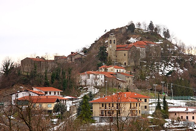
Роккаверано (Roccaverano, Roccaverano)

- коммуна Италии
 Hiking in Роккаверано
Roccaverano is a charming hilltop village located in the Piedmont region of Italy, known for its scenic landscapes and rich agricultural heritage, particularly its local cheese, Roccaverano cheese. The surrounding area offers a variety of hiking opportunities that allow visitors to explore the beautiful countryside, rolling hills, vineyards, and forests.
Hiking in Roccaverano:
-
Trails and Routes:
- Local Trails: There are numerous marked trails around Roccaverano that cater to different skill levels, ranging from easy strolls through vineyards to more challenging hikes in the surrounding hills.
- Natural Parks: Nearby natural parks provide hiking trails that boast diverse flora and fauna, perfect for nature lovers and wildlife photographers.
-
Scenic Views:
- Hikes in the area often reward you with stunning panoramic views of the Tanaro Valley and the surrounding Langhe and Monferrato hills. The vibrant colors of the vineyards and countryside make for picturesque scenery, especially during the fall.
-
Cultural Heritage:
- As you hike, you may encounter ancient ruins, charming chapels, and traditional stone houses that highlight the region's rich cultural history. This aspect adds an enriching experience to your hikes, as you can appreciate both nature and local heritage.
-
Flora and Fauna:
- The region is home to a variety of plant and animal species. Keep an eye out for local wildlife, including various bird species, and enjoy the diverse plant life, especially during spring and early summer when wildflowers bloom.
-
Best Time to Hike:
- The ideal time for hiking in Roccaverano is during the spring and fall months when the weather is mild, and the landscapes are particularly beautiful. Summer can be hot, while winter may bring snow to the higher elevations.
-
Accessibility:
- Roccaverano is accessible by car, and local transport is available from larger towns in the region. Parking options are generally available, allowing hikers to start their adventures with ease.
Recommendations:
- Always check trail maps and local regulations before heading out.
- Bring sufficient water, snacks, and appropriate gear based on the trail and weather conditions.
- Consider hiring a local guide if you want an in-depth understanding of the area’s ecology and history.
Overall, hiking in Roccaverano offers a perfect blend of natural beauty, cultural insights, and outdoor adventure that can cater to both casual walkers and serious hikers alike.
- Страна:

- Почтовый код: 14050
- Телефонный код: 0144
- Код автомобильного номера: AT
- Координаты: 44° 35' 36" N, 8° 16' 24" E


- GPS треки (wikiloc): [Ссылка]
- Высота над уровнем моря: 759 м m
- Площадь: 29.98 кв.км
- Население: 396
- Веб сайт: http://www.comune.roccaverano.at.it
- Википедия русская: wiki(ru)
- Википедия английская: wiki(en)
- Википедия национальная: wiki(it)
- Хранилище Wikidata: Wikidata: Q17854
- Катеория в википедии: [Ссылка]
- код Freebase: [/m/0gbj4s]
- код GeoNames: Альт: [6543498]
- код VIAF: Альт: [238817033]
- ID отношения в OpenStreetMap: [43311]
- код GND: Альт: [7675511-3]
- код ISTAT: 005094
- кадастровый код Италии: H451
Граничит с регионами:
Дениче
- коммуна в регионе Пьемонт, Италия
Hiking in Дениче
It seems you might be referring to a specific location for hiking, but "Denice" is not a recognized hiking destination in major hiking directories or outdoor resources. It's possible you meant "Denali" in Alaska, which is a popular hiking and outdoor destination. If you meant a specific town or area named Denice, please provide me with more details so I can assist you better....
- Страна:
- Почтовый код: 15010
- Телефонный код: 0144
- Код автомобильного номера: AL
- Координаты: 44° 35' 59" N, 8° 20' 3" E
- GPS треки (wikiloc): [Ссылка]
- Высота над уровнем моря: 387 м m
- Площадь: 7.46 кв.км
- Население: 172
- Веб сайт: [Ссылка]
Монтекьяро-д'Акви
- коммуна в регионе Пьемонт, Италия
Hiking in Монтекьяро-д'Акви
Montechiaro d'Acqui is a charming village located in the Piedmont region of Italy, particularly known for its beautiful landscapes and rich natural environment. While it may not be a major hiking destination, it offers various trails suitable for hiking enthusiasts looking to explore the lesser-known paths of the region....
- Страна:
- Почтовый код: 15010
- Телефонный код: 0144
- Код автомобильного номера: AL
- Координаты: 44° 35' 43" N, 8° 22' 47" E
- GPS треки (wikiloc): [Ссылка]
- Высота над уровнем моря: 540 м m
- Площадь: 17.6 кв.км
- Население: 540
- Веб сайт: [Ссылка]
Спиньо-Монферрато
- коммуна в регионе Пьемонт, Италия
Hiking in Спиньо-Монферрато
Spigno Monferrato, located in the Piedmont region of northwestern Italy, is known for its beautiful landscapes, rolling hills, and rich vineyards. Hiking in this area offers a wonderful opportunity to explore both nature and local culture....
- Страна:
- Почтовый код: 15018
- Телефонный код: 0144
- Код автомобильного номера: AL
- Координаты: 44° 32' 39" N, 8° 20' 6" E
- GPS треки (wikiloc): [Ссылка]
- Высота над уровнем моря: 217 м m
- Площадь: 54.86 кв.км
- Население: 1015
- Веб сайт: [Ссылка]


Буббио
- коммуна Италии
Hiking in Буббио
Bubbio is a charming village located in the Piedmont region of Italy, nestled in the mountainous landscape of the Langhe and Monferrato areas. Hiking in and around Bubbio offers a delightful mix of natural beauty, cultural heritage, and picturesque views....
- Страна:
- Почтовый код: 14051
- Телефонный код: 0144
- Код автомобильного номера: AT
- Координаты: 44° 39' 52" N, 8° 17' 46" E
- GPS треки (wikiloc): [Ссылка]
- Высота над уровнем моря: 224 м m
- Площадь: 15.76 кв.км
- Население: 847
- Веб сайт: [Ссылка]


Чессоле
- коммуна Италии
Hiking in Чессоле
Cessole is a charming village located in the Piedmont region of Italy, within the province of Asti. Surrounded by beautiful vineyards and rolling hills, it offers a variety of hiking opportunities for nature enthusiasts and outdoor adventurers. Here are some key points about hiking in Cessole:...
- Страна:
- Почтовый код: 14050
- Телефонный код: 0144
- Код автомобильного номера: AT
- Координаты: 44° 39' 0" N, 8° 14' 41" E
- GPS треки (wikiloc): [Ссылка]
- Высота над уровнем моря: 280 м m
- Площадь: 11.78 кв.км
- Население: 402
- Веб сайт: [Ссылка]
Лоаццоло
- коммуна Италии
Hiking in Лоаццоло
Loazzolo is a charming municipality located in the Piedmont region of northern Italy, known for its breathtaking landscapes, rolling hills, and vineyards. It is a great destination for hiking enthusiasts who appreciate both natural beauty and cultural heritage....
- Страна:
- Почтовый код: 14050
- Телефонный код: 0144
- Код автомобильного номера: AT
- Координаты: 44° 40' 12" N, 8° 15' 34" E
- GPS треки (wikiloc): [Ссылка]
- Высота над уровнем моря: 430 м m
- Площадь: 14.82 кв.км
- Население: 341
- Веб сайт: [Ссылка]


Момбальдоне
- коммуна Италии
Hiking in Момбальдоне
Mombaldone is a charming village located in the Piedmont region of Italy, nestled in the hills of the Langhe and Monferrato area. While it may not be one of the most well-known hiking destinations, it offers beautiful landscapes, rich history, and various trails suitable for hikers of different levels....
- Страна:
- Почтовый код: 14050
- Телефонный код: 0144
- Код автомобильного номера: AT
- Координаты: 44° 34' 19" N, 8° 20' 9" E
- GPS треки (wikiloc): [Ссылка]
- Высота над уровнем моря: 219 м m
- Площадь: 11.96 кв.км
- Население: 198
- Веб сайт: [Ссылка]


Монастеро-Бормида
- коммуна Италии
Hiking in Монастеро-Бормида
Monastero Bormida is a charming village located in the Piedmont region of Italy, known for its picturesque landscapes, vineyards, and serene countryside. It is an excellent destination for hiking enthusiasts who wish to explore the beautiful terrain of the area....
- Страна:
- Почтовый код: 14058
- Телефонный код: 0144
- Код автомобильного номера: AT
- Координаты: 44° 38' 58" N, 8° 19' 40" E
- GPS треки (wikiloc): [Ссылка]
- Высота над уровнем моря: 191 м m
- Площадь: 14.21 кв.км
- Население: 934
- Веб сайт: [Ссылка]


Ольмо-Джентиле
- коммуна Италии
Hiking in Ольмо-Джентиле
Olmo Gentile is a picturesque area located in the Liguria region of Italy, known for its beautiful landscapes and hiking opportunities. The area offers a mix of gentle hills and more challenging terrains, making it suitable for hikers of various experience levels....
- Страна:
- Почтовый код: 14050
- Телефонный код: 0144
- Код автомобильного номера: AT
- Координаты: 44° 35' 12" N, 8° 14' 53" E
- GPS треки (wikiloc): [Ссылка]
- Высота над уровнем моря: 615 м m
- Площадь: 5.62 кв.км
- Население: 77
- Веб сайт: [Ссылка]
Сан-Джорджо-Скарампи
- коммуна Италии
Hiking in Сан-Джорджо-Скарампи
San Giorgio Scarampi is a charming village located in the Piedmont region of Italy, surrounded by beautiful landscapes ideal for hiking. The area offers a variety of trails that cater to different skill levels, from easy walks to more challenging hikes....
- Страна:
- Почтовый код: 14059
- Телефонный код: 0144
- Код автомобильного номера: AT
- Координаты: 44° 36' 43" N, 8° 14' 37" E
- GPS треки (wikiloc): [Ссылка]
- Высота над уровнем моря: 655 м m
- Площадь: 6.15 кв.км
- Население: 114
- Веб сайт: [Ссылка]
Сероле
- коммуна Италии
Hiking in Сероле
Serole, a region known for its scenic beauty and diverse landscapes, offers a variety of hiking opportunities suitable for different skill levels. Here are some key details about hiking in Serole:...
- Страна:
- Почтовый код: 14050
- Телефонный код: 0144
- Код автомобильного номера: AT
- Координаты: 44° 33' 18" N, 8° 15' 39" E
- GPS треки (wikiloc): [Ссылка]
- Высота над уровнем моря: 588 м m
- Площадь: 12.33 кв.км
- Население: 114
- Веб сайт: [Ссылка]
Везиме
- коммуна Италии
Hiking in Везиме
Vesime is a picturesque town located in the Piedmont region of Italy, known for its beautiful landscapes, vineyards, and charming villages. Hiking in Vesime offers an opportunity to explore the stunning hills and countryside, characterized by rolling vineyards, forests, and scenic views....
- Страна:
- Почтовый код: 14059
- Телефонный код: 0144
- Код автомобильного номера: AT
- Координаты: 44° 38' 12" N, 8° 13' 42" E
- GPS треки (wikiloc): [Ссылка]
- Высота над уровнем моря: 225 м m
- Площадь: 13.17 кв.км
- Население: 627
- Веб сайт: [Ссылка]