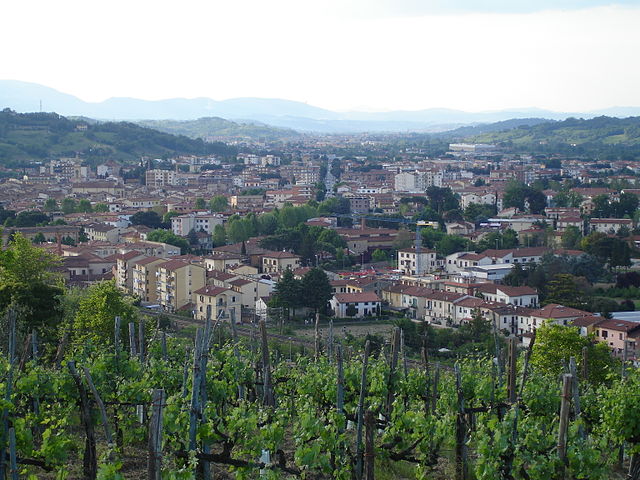
Бучине (Bucine, Bucine)
.svg)
- коммуна Италии
 Hiking in Бучине
Bucine, located in the heart of Tuscany, Italy, offers a beautiful setting for hiking with its rolling hills, vineyards, olive groves, and charming villages. The area is known for its picturesque landscapes and mild climate, making it a great destination for outdoor enthusiasts. Here are some highlights for hiking in Bucine:
Trails and Routes
-
Sentiero della Bonifica: This trail runs along the Arno River and offers beautiful views of the surrounding countryside. It is well-marked and suitable for both walking and cycling.
-
Chianti Trail: While not directly in Bucine, many trails connect to the nearby Chianti region. These trails allow you to explore the stunning vineyards and traditional Tuscan scenery.
-
Local Nature Trails: There are several lesser-known trails that lead through the hills surrounding Bucine, offering a chance to experience the local flora and fauna, with opportunities for birdwatching and spotting wildlife.
Points of Interest
-
Castles and Historic Sites: Hiking in Bucine often provides access to ancient castles and historic towns, such as the nearby village of Ambra and the remains of the castle at Civitella in Val di Chiana.
-
Vineyards and Olive Groves: Many trails pass through agricultural lands, allowing for exploration of the local vineyards and olive groves. Some wineries even offer tastings and tours, which can be a great way to relax after a hike.
Tips for Hiking in Bucine
-
Best Time to Hike: Spring (April to June) and fall (September to October) are ideal for hiking due to mild temperatures and vibrant landscapes.
-
Prepare for Varied Terrain: The terrain can vary, so wear appropriate footwear and consider bringing walking sticks for the more challenging routes.
-
Stay Hydrated and Pack Snacks: Ensure you carry enough water and some light snacks, especially if you plan to hike for several hours.
-
Respect Nature: Stay on marked paths, observe local wildlife from a distance, and practice "Leave No Trace" principles.
Conclusion
Hiking in Bucine offers diverse experiences, combining natural beauty with rich cultural history. Whether you're a seasoned hiker or a beginner, you can enjoy the serenity and breathtaking views of Tuscany. Don't forget to take your camera to capture the stunning landscapes!
- Страна:

- Почтовый код: 52021
- Телефонный код: 055
- Код автомобильного номера: AR
- Координаты: 43° 28' 39" N, 11° 36' 57" E


- GPS треки (wikiloc): [Ссылка]
- Высота над уровнем моря: 207 м m
- Площадь: 131.47 кв.км
- Население: 10087
- Веб сайт: http://www.comune.bucine.ar.it
- Википедия русская: wiki(ru)
- Википедия английская: wiki(en)
- Википедия национальная: wiki(it)
- Хранилище Wikidata: Wikidata: Q52067
- Галерея изображений в википедии: [Ссылка]
- Катеория в википедии: [Ссылка]
- код Freebase: [/m/0gl_zl]
- код GeoNames: Альт: [6538585]
- код VIAF: Альт: [159171823]
- ID отношения в OpenStreetMap: [42422]
- код GND: Альт: [4245793-2]
- UN/LOCODE: [ITUNE]
- код ISTAT: 051005
- кадастровый код Италии: B243
Граничит с регионами:


Чивителла-ин-Валь-ди-Кьяна
- коммуна Италии
Hiking in Чивителла-ин-Валь-ди-Кьяна
Civitella in Val di Chiana, located in the beautiful Tuscany region of Italy, offers a variety of hiking opportunities that allow you to explore its stunning landscapes, rich history, and charming villages. Here are some key details to consider when hiking in this area:...
- Страна:
- Почтовый код: 52041
- Телефонный код: 0575
- Код автомобильного номера: AR
- Координаты: 43° 24' 19" N, 11° 46' 14" E
- GPS треки (wikiloc): [Ссылка]
- Высота над уровнем моря: 280 м m
- Площадь: 100.19 кв.км
- Население: 9035
- Веб сайт: [Ссылка]


Монте-Сан-Савино
- Коммуны Италии
Hiking in Монте-Сан-Савино
Monte San Savino is a charming town located in the Tuscany region of Italy, known for its historical architecture and stunning landscapes. While it may not be as famous for hiking as some of the other areas in Tuscany, it offers beautiful trails that allow you to experience the region's natural beauty and rich cultural heritage....
- Страна:
- Почтовый код: 52048
- Телефонный код: 0575
- Код автомобильного номера: AR
- Координаты: 43° 19' 49" N, 11° 43' 51" E
- GPS треки (wikiloc): [Ссылка]
- Высота над уровнем моря: 330 м m
- Площадь: 89.87 кв.км
- Население: 8675
- Веб сайт: [Ссылка]

Монтеварки
- коммуна Италии
Hiking in Монтеварки
Montevarchi, located in the Tuscany region of Italy, is a charming town surrounded by picturesque landscapes, making it an excellent area for hiking enthusiasts. The region is known for its rolling hills, vineyards, and the nearby Chianti area, offering various trails for different skill levels....
- Страна:
- Почтовый код: 52025
- Телефонный код: 055
- Код автомобильного номера: AR
- Координаты: 43° 31' 24" N, 11° 34' 4" E
- GPS треки (wikiloc): [Ссылка]
- Высота над уровнем моря: 144 м m
- Площадь: 56.67 кв.км
- Население: 24440
- Веб сайт: [Ссылка]


Кастельнуово-Берарденга
- коммуна Италии
Hiking in Кастельнуово-Берарденга
Castelnuovo Berardenga is a charming town located in the province of Siena in Tuscany, Italy. The area is renowned for its beautiful landscapes, rolling hills, vineyards, and olive groves, making it a fantastic destination for hiking enthusiasts....
- Страна:
- Почтовый код: 53019
- Телефонный код: 0577
- Код автомобильного номера: SI
- Координаты: 43° 20' 50" N, 11° 30' 15" E
- GPS треки (wikiloc): [Ссылка]
- Высота над уровнем моря: 351 м m
- Площадь: 177.11 кв.км
- Население: 9086
- Веб сайт: [Ссылка]


Гайоле-ин-Кьянти
- коммуна Италии
Hiking in Гайоле-ин-Кьянти
Gaiole in Chianti is a charming village located in the heart of the Chianti region of Tuscany, Italy. This area is renowned for its stunning landscapes, vineyards, olive groves, and rolling hills, making it a fantastic destination for hiking enthusiasts. Here are some highlights and tips for hiking in Gaiole in Chianti:...
- Страна:
- Почтовый код: 53013
- Телефонный код: 0577
- Код автомобильного номера: SI
- Координаты: 43° 28' 0" N, 11° 26' 0" E
- GPS треки (wikiloc): [Ссылка]
- Высота над уровнем моря: 360 м m
- Площадь: 128.89 кв.км
- Население: 2758
- Веб сайт: [Ссылка]


Раполано-Терме
- коммуна Италии
Hiking in Раполано-Терме
Rapolano Terme, located in the beautiful Tuscany region of Italy, is known for its stunning landscapes, thermal springs, and charming villages. Hiking around Rapolano Terme offers a mix of scenic views, historic sites, and the opportunity to explore the rich natural environment....
- Страна:
- Почтовый код: 53040
- Телефонный код: 0577
- Код автомобильного номера: SI
- Координаты: 43° 17' 0" N, 11° 36' 0" E
- GPS треки (wikiloc): [Ссылка]
- Высота над уровнем моря: 334 м m
- Площадь: 83.04 кв.км
- Население: 5305
- Веб сайт: [Ссылка]