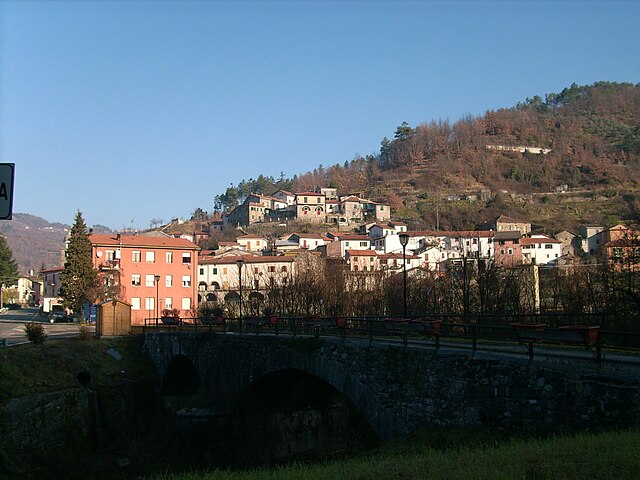
Каличе-аль-Корновильо (Calice al Cornoviglio, Calice al Cornoviglio)
.svg)
- коммуна Италии
 Hiking in Каличе-аль-Корновильо
Calice al Cornoviglio, located in the Liguria region of Italy, is a charming village surrounded by the stunning landscapes of the Apuan Alps and close to the Cinque Terre National Park. It's a perfect spot for hikers looking for a mix of coastal and mountain trails, rich in natural beauty and cultural heritage.
Hiking Trails
-
Sentiero della Libertà: This trail offers scenic views of the surrounding countryside and takes you through ancient villages. It's a great route for experiencing the local flora and fauna.
-
Monte Cornoviglio: A hike to the summit of this mountain rewards you with panoramic views of both the sea and the mountains. The trail is moderately challenging and ideal for those looking for a good workout.
-
Val di Vara Trails: The trails in the Val di Vara region are not far from Calice al Cornoviglio. These routes vary in difficulty and length, making them suitable for hikers of all levels.
-
Historic Trail to Brugnato: This trail connects Calice al Cornoviglio to the historical town of Brugnato, where you can explore ancient architecture and enjoy a break in a charming setting.
Tips for Hiking in the Area
- Best Seasons: Spring (April to June) and autumn (September to October) are ideal times for hiking due to mild weather and beautiful scenery.
- Preparation: Bring plenty of water and snacks, and wear sturdy hiking boots. The trails can be rocky and uneven.
- Local Regulations: Always check local regulations regarding trail access, especially since some areas might be part of protected parks.
- Maps and Guides: Consider obtaining a detailed map or hiring a local guide to enhance your hiking experience and ensure you explore safely.
Cultural Experience
In addition to the natural beauty, Calice al Cornoviglio is home to several historical sites, including old churches and ruins. After a day of hiking, be sure to explore the village, sample local cuisine, and enjoy the cozy atmosphere.
Whether you're an experienced hiker or a beginner, Calice al Cornoviglio offers a memorable hiking experience amidst beautiful landscapes and rich cultural history.
- Страна:

- Почтовый код: 19020
- Телефонный код: 0187
- Код автомобильного номера: SP
- Координаты: 44° 14' 35" N, 9° 50' 11" E


- GPS треки (wikiloc): [Ссылка]
- Высота над уровнем моря: 402 м m
- Площадь: 33.75 кв.км
- Население: 1105
- Веб сайт: http://www.comune.calice-ligure.sv.it
- Википедия русская: wiki(ru)
- Википедия английская: wiki(en)
- Википедия национальная: wiki(it)
- Хранилище Wikidata: Wikidata: Q270064
- Катеория в википедии: [Ссылка]
- код Freebase: [/m/0ghx78]
- код GeoNames: Альт: [6537069]
- код VIAF: Альт: [234817427]
- ID отношения в OpenStreetMap: [42939]
- код ISTAT: 011008
- кадастровый код Италии: B410
Граничит с регионами:


Беверино
- коммуна Италии
Hiking in Беверино
Beverino is a charming village located in the Liguria region of Italy, close to the more famous Cinque Terre. This area offers stunning landscapes, lush greenery, and fantastic views, making it an excellent destination for hiking enthusiasts....
- Страна:
- Почтовый код: 19020
- Телефонный код: 0187
- Код автомобильного номера: SP
- Координаты: 44° 11' 45" N, 9° 46' 7" E
- GPS треки (wikiloc): [Ссылка]
- Высота над уровнем моря: 73 м m
- Площадь: 34.95 кв.км
- Население: 2396
- Веб сайт: [Ссылка]


Фолло
- коммуна Италии
Hiking in Фолло
Follo, located in the Liguria region of Italy, is surrounded by beautiful landscapes, making it an attractive destination for hiking enthusiasts. This area offers a variety of trails that cater to different skill levels, from leisurely walks to more challenging hikes. Here are some highlights of hiking in Follo:...
- Страна:
- Почтовый код: 19020
- Телефонный код: 0187
- Код автомобильного номера: SP
- Координаты: 44° 9' 58" N, 9° 50' 54" E
- GPS треки (wikiloc): [Ссылка]
- Высота над уровнем моря: 70 м m
- Площадь: 23.27 кв.км
- Население: 6296
- Веб сайт: [Ссылка]

Роккетта-ди-Вара
- коммуна Италии
Hiking in Роккетта-ди-Вара
Rocchetta di Vara is a charming village located in the Liguria region of Italy, nestled in the hills of the Val di Vara. This area is known for its picturesque landscapes, lush greenery, and diverse hiking trails that appeal to all levels of hikers....
- Страна:
- Почтовый код: 19020
- Телефонный код: 0187
- Код автомобильного номера: SP
- Координаты: 44° 15' 4" N, 9° 45' 26" E
- GPS треки (wikiloc): [Ссылка]
- Высота над уровнем моря: 220 м m
- Площадь: 32.66 кв.км
- Население: 701
- Веб сайт: [Ссылка]


Мулаццо
- коммуна Италии
Hiking in Мулаццо
Mulazzo is a charming village located in the province of Massa-Carrara in Tuscany, Italy. It is situated in the Apuan Alps, which offers stunning landscapes and a variety of hiking opportunities. Here’s an overview of what you might expect when hiking in this beautiful area:...
- Страна:
- Почтовый код: 54026
- Телефонный код: 0187
- Код автомобильного номера: MS
- Координаты: 44° 19' 1" N, 9° 53' 26" E
- GPS треки (wikiloc): [Ссылка]
- Высота над уровнем моря: 351 м m
- Площадь: 62.51 кв.км
- Население: 2425
- Веб сайт: [Ссылка]


Поденцана
- коммуна Италии
Hiking in Поденцана
Podenzana is a charming village located in the province of Massa-Carrara in Tuscany, Italy. Surrounded by the beautiful Apuan Alps and nestled in the Apennine Mountains, it offers a variety of hiking opportunities with stunning views and picturesque landscapes....
- Страна:
- Почтовый код: 54010
- Телефонный код: 0187
- Код автомобильного номера: MS
- Координаты: 44° 12' 0" N, 9° 57' 0" E
- GPS треки (wikiloc): [Ссылка]
- Высота над уровнем моря: 312 м m
- Площадь: 17.1 кв.км
- Население: 2175
- Веб сайт: [Ссылка]


Трезана
- коммуна Италии
Hiking in Трезана
Tresana, located in the Lunigiana region of Tuscany, Italy, is a picturesque area that offers a variety of hiking opportunities. Nestled between the Apuan Alps and the Apennines, it is characterized by beautiful landscapes, charming villages, and rich history....
- Страна:
- Почтовый код: 54012
- Телефонный код: 0187
- Код автомобильного номера: MS
- Координаты: 44° 14' 0" N, 9° 57' 0" E
- GPS треки (wikiloc): [Ссылка]
- Высота над уровнем моря: 112 м m
- Площадь: 44.45 кв.км
- Население: 1999
- Веб сайт: [Ссылка]