Кальвизано (Calvisano, Calvisano)
.svg)
- коммуна Италии
 Hiking in Кальвизано
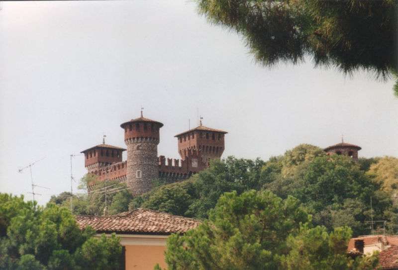
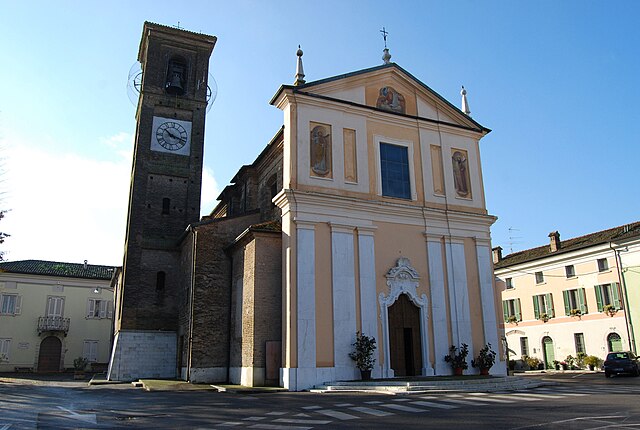
Calvisano is a charming town located in the Lombardy region of northern Italy, known for its picturesque landscapes and proximity to various natural reserves. Hiking opportunities around Calvisano are typically characterized by beautiful scenery, lush countryside, and serene rural settings.
Hiking Trails and Areas
-
Local Trails: Calvisano and its surroundings have several local trails that offer varying degrees of difficulty. These trails often wind through fields, vineyards, and along small rivers, providing a tranquil hiking experience.
-
Parco Regionale dell'Oglio Sud: Just a short drive from Calvisano, this regional park features numerous trails that follow the Oglio River. The park is rich in biodiversity and offers a chance to see various plant and animal species.
-
Brescia Hills: To the northwest, you can explore trails leading into the hills surrounding the city of Brescia. These trails can offer more challenging hikes with stunning views of the valley and Lake Iseo in the distance.
-
Monte Isola: While not immediately adjacent to Calvisano, taking a day trip to Lake Iseo and hiking on Monte Isola, one of the largest freshwater islands in Europe, can be a rewarding experience. The island features well-marked trails and breathtaking views.
Tips for Hiking in Calvisano
-
Best Time to Hike: Spring (April-June) and autumn (September-October) are the best times for hiking in this region, as the weather is generally mild and the landscapes are most vibrant.
-
What to Bring: Always pack enough water, snacks, a map or GPS device, sunscreen, and appropriate hiking gear including sturdy shoes.
-
Local Regulations: Be aware of local wildlife and natural habitats; stick to marked trails to minimize your impact on the environment.
-
Cultural Experience: Consider stopping by local agriturismos (farm stays) or restaurants to taste regional cuisine along your hiking routes.
Hiking in and around Calvisano offers a unique blend of natural beauty and cultural experiences, making it a great destination for those looking to enjoy the outdoors in Italy. If you need further information or specific trail recommendations, feel free to ask!
- Страна:

- Почтовый код: 25012
- Телефонный код: 030
- Код автомобильного номера: BS
- Координаты: 45° 20' 56" N, 10° 20' 45" E


- GPS треки (wikiloc): [Ссылка]
- Высота над уровнем моря: 67 м m
- Площадь: 44.83 кв.км
- Население: 8543
- Веб сайт: http://www.comune.calvisano.bs.it
- Википедия русская: wiki(ru)
- Википедия английская: wiki(en)
- Википедия национальная: wiki(it)
- Хранилище Wikidata: Wikidata: Q103730
- Катеория в википедии: [Ссылка]
- код Freebase: [/m/041pr6]
- код GeoNames: Альт: [6541709]
- код VIAF: Альт: [155237702]
- ID отношения в OpenStreetMap: [44718]
- WOEID: [711767]
- код TGN: [1043753]
- UN/LOCODE: [ITAVS]
- код ISTAT: 017034
- кадастровый код Италии: B450
Граничит с регионами:

Аккуафредда
- коммуна Италии
Hiking in Аккуафредда
Acquafredda is a charming coastal area located in southern Italy, specifically in the region of Basilicata. It offers various opportunities for hiking enthusiasts to explore its beautiful landscapes, featuring a mix of coastal views, rugged cliffs, and lush greenery. Here are some highlights about hiking in Acquafredda:...
- Страна:
- Почтовый код: 25010
- Телефонный код: 030
- Код автомобильного номера: BS
- Координаты: 45° 18' 25" N, 10° 24' 48" E
- GPS треки (wikiloc): [Ссылка]
- Высота над уровнем моря: 56 м m
- Площадь: 9 кв.км
- Население: 1565
- Веб сайт: [Ссылка]

Карпенедоло
- коммуна Италии
Hiking in Карпенедоло
Carpenedolo, located in the Lombardy region of Italy, is a charming town that offers access to scenic hiking opportunities, primarily within the surrounding countryside and nearby natural areas. While Carpenedolo itself may not be widely recognized for extensive hiking trails, it serves as a great starting point for exploring the natural beauty of Lombardy....
- Страна:
- Почтовый код: 25013
- Телефонный код: 030
- Код автомобильного номера: BS
- Координаты: 45° 21' 55" N, 10° 25' 56" E
- GPS треки (wikiloc): [Ссылка]
- Высота над уровнем моря: 78 м m
- Площадь: 29.84 кв.км
- Население: 12957
- Веб сайт: [Ссылка]

Геди
- коммуна Италии
Hiking in Геди
Ghedi, located in the Lombardy region of northern Italy, is primarily known for its agricultural landscape rather than extensive hiking trails. However, the surrounding areas, such as the nearby hills and nature reserves, offer opportunities for outdoor activities including hiking....
- Страна:
- Почтовый код: 25016
- Телефонный код: 030
- Код автомобильного номера: BS
- Координаты: 45° 24' 7" N, 10° 16' 49" E
- GPS треки (wikiloc): [Ссылка]
- Высота над уровнем моря: 85 м m
- Площадь: 60 кв.км
- Население: 18828
- Веб сайт: [Ссылка]

Изорелла
- коммуна Италии
Hiking in Изорелла
Isorella is a charming municipality located in the Lombardy region of Italy, known for its picturesque landscapes and tranquil natural settings. While it may not be as widely known for hiking as some other regions in Italy, there are definitely some opportunities for outdoor activities....
- Страна:
- Почтовый код: 25010
- Телефонный код: 030
- Код автомобильного номера: BS
- Координаты: 45° 18' 33" N, 10° 19' 24" E
- GPS треки (wikiloc): [Ссылка]
- Высота над уровнем моря: 56 м m
- Площадь: 15.33 кв.км
- Население: 4077
- Веб сайт: [Ссылка]
Монтикьяри
- коммуна Италии
Hiking in Монтикьяри
Montichiari, located in the province of Brescia in Northern Italy, is not typically known as a major hiking destination compared to other regions in the Italian Alps or the Dolomites. However, it is surrounded by scenic countryside, rolling hills, and offers some opportunities for outdoor activities including hiking....
- Страна:
- Почтовый код: 25018
- Телефонный код: 030
- Код автомобильного номера: BS
- Координаты: 45° 24' 58" N, 10° 23' 30" E
- GPS треки (wikiloc): [Ссылка]
- Высота над уровнем моря: 108 м m
- Площадь: 81.192 кв.км
- Население: 25714
- Веб сайт: [Ссылка]
Визано
- коммуна Италии
Hiking in Визано
Visano, a quaint small town in the Lombardy region of Italy, is not widely known for extensive hiking trails like some other areas in Italy. However, it is situated close to beautiful natural landscapes, including the Alps and the Po River, making it a great starting point for hiking adventures....
- Страна:
- Почтовый код: 25010
- Телефонный код: 030
- Код автомобильного номера: BS
- Координаты: 45° 19' 9" N, 10° 22' 24" E
- GPS треки (wikiloc): [Ссылка]
- Высота над уровнем моря: 59 м m
- Площадь: 11.22 кв.км
- Население: 1956
- Веб сайт: [Ссылка]