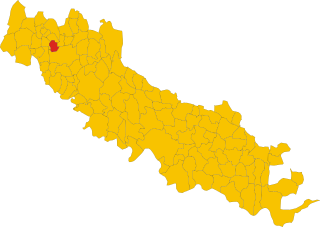
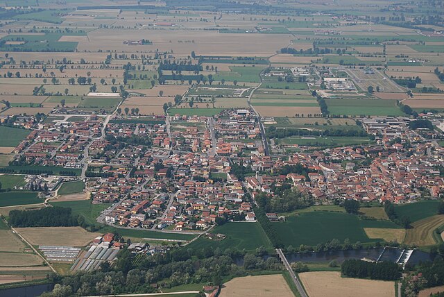
Кампаньола-Кремаска (Campagnola Cremasca, Campagnola Cremasca)
.svg)
- коммуна Италии
 Hiking in Кампаньола-Кремаска
Campagnola Cremasca is a small town located in the Lombardy region of Italy, known for its picturesque landscapes and rural charm. While the area may not be as famous for hiking as some mountainous regions of Italy, there are still opportunities for enjoyable walks and hikes in the surrounding countryside.
Hiking Opportunities:
-
Local Trails: The countryside around Campagnola Cremasca features various trails that allow you to explore the natural beauty of the area. These trails typically take you through fields, orchards, and small forests.
-
Cremasca Valley: The nearby Cremasca Valley offers a more extensive network of trails. You can enjoy the serene landscape, which includes waterways, agricultural lands, and quaint villages.
-
Nearby Parks: Consider exploring nearby nature parks or reserves. For example, the Parco Regionale della Serenissima is located a bit further away but offers beautiful natural pathways and is perfect for a day hike.
Tips for Hiking in Campagnola Cremasca:
- Terrain: Expect mostly flat terrain, ideal for leisurely walks rather than strenuous hiking. It's a great option for families or casual hikes.
- Weather: Check local weather conditions before heading out, as they can change. Spring and early autumn are likely the best seasons for hiking, with mild temperatures and beautiful scenery.
- Hydration and Snacks: Bring plenty of water and some snacks, especially if you plan to hike longer trails or spend time in nature.
- Respect Nature: Always follow Leave No Trace principles - carry out what you carry in, stay on marked paths, and respect local wildlife.
Additional Activities:
While in Campagnola Cremasca, you may also enjoy local culture and cuisine. Exploring surrounding villages, cycling through the countryside, or even visiting historical sites can enhance your experience.
Overall, hiking in and around Campagnola Cremasca provides a delightful way to connect with nature and appreciate the charm of rural Italy.
- Страна:

- Почтовый код: 26013
- Телефонный код: 0373
- Код автомобильного номера: CR
- Координаты: 45° 24' 0" N, 9° 40' 0" E


- GPS треки (wikiloc): [Ссылка]
- Высота над уровнем моря: 81 м m
- Площадь: 4.64 кв.км
- Население: 686
- Веб сайт: https://www.comune.campagnolacremasca.cr.it/
- Википедия русская: wiki(ru)
- Википедия английская: wiki(en)
- Википедия национальная: wiki(it)
- Хранилище Wikidata: Wikidata: Q42770
- Катеория в википедии: [Ссылка]
- код Freebase: [/m/0gjyhq]
- код GeoNames: Альт: [6542971]
- ID отношения в OpenStreetMap: [44901]
- код ISTAT: 019011
- кадастровый код Италии: B498
Граничит с регионами:


Казалетто-Ваприо
- коммуна Италии
Hiking in Казалетто-Ваприо
Casaletto Vaprio, located in the Lombardy region of Italy, is not typically known as a major hiking destination compared to other areas in the region like the nearby Adda River Park or the Alps. However, the surrounding countryside offers some pleasant walking and hiking opportunities....
- Страна:
- Почтовый код: 26010
- Телефонный код: 0373
- Код автомобильного номера: CR
- Координаты: 45° 24' 0" N, 9° 38' 0" E
- GPS треки (wikiloc): [Ссылка]
- Высота над уровнем моря: 87 м m
- Площадь: 5.4 кв.км
- Население: 1773
- Веб сайт: [Ссылка]


Крема
- коммуна Италии
Hiking in Крема
Crema, located in the Lombardy region of northern Italy, is not as widely known for hiking as some of the nearby areas in the Italian Alps or the Apennines. However, it does offer some lovely landscapes and walking trails for those who enjoy a more serene and gentle hiking experience....
- Страна:
- Почтовый код: 26013
- Телефонный код: 0373
- Код автомобильного номера: CR
- Координаты: 45° 22' 0" N, 9° 41' 0" E
- GPS треки (wikiloc): [Ссылка]
- Высота над уровнем моря: 79 м m
- Площадь: 34 кв.км
- Население: 34452
- Веб сайт: [Ссылка]
Капральба
- коммуна Италии
Hiking in Капральба
Capralba, located in the Lombardy region of Italy, is known for its serene landscapes and opportunities for outdoor activities, including hiking. While it may not be as famous as some larger hiking destinations in Italy, it offers beautiful rural scenery, charming villages, and a chance to experience nature away from the crowds....
- Страна:
- Почтовый код: 26010
- Телефонный код: 0373
- Код автомобильного номера: CR
- Координаты: 45° 27' 0" N, 9° 39' 0" E
- GPS треки (wikiloc): [Ссылка]
- Высота над уровнем моря: 93 м m
- Площадь: 13.45 кв.км
- Население: 2347
- Веб сайт: [Ссылка]

Кремозано
- коммуна Италии
Hiking in Кремозано
Cremosano, a small town in the province of Cremona, Italy, is surrounded by peaceful countryside and offers several opportunities for hiking and outdoor activities. While it may not be as famous as other hiking destinations in Italy, it has its charm and distinctive landscapes. Here are some aspects to consider when planning a hiking adventure in and around Cremosano:...
- Страна:
- Почтовый код: 26010
- Телефонный код: 0373
- Код автомобильного номера: CR
- Координаты: 45° 24' 0" N, 9° 38' 0" E
- GPS треки (wikiloc): [Ссылка]
- Высота над уровнем моря: 82 м m
- Площадь: 5.76 кв.км
- Население: 1755
- Веб сайт: [Ссылка]
Пьяненго
- коммуна Италии
Hiking in Пьяненго
Pianengo is a small town in the Lombardy region of Italy, near the Po River, situated within a predominantly flat landscape that offers a different kind of outdoor experience compared to mountainous regions. While it may not be renowned for traditional hiking trails, there are opportunities for hiking and enjoying nature within the surrounding area. Here are some aspects to consider if you're planning a hiking experience near Pianengo:...
- Страна:
- Почтовый код: 26010
- Телефонный код: 0373
- Код автомобильного номера: CR
- Координаты: 45° 24' 0" N, 9° 42' 0" E
- GPS треки (wikiloc): [Ссылка]
- Высота над уровнем моря: 83 м m
- Площадь: 5.76 кв.км
- Население: 2549
- Веб сайт: [Ссылка]

Серньано
- коммуна Италии
Hiking in Серньано
Sergnano is a small town located in the Lombardy region of Italy, near the city of Crema. While it's not widely known as a hiking destination, there are a few opportunities for outdoor activities in and around the area....
- Страна:
- Почтовый код: 26010
- Телефонный код: 0373
- Код автомобильного номера: CR
- Координаты: 45° 26' 0" N, 9° 42' 0" E
- GPS треки (wikiloc): [Ссылка]
- Высота над уровнем моря: 88 м m
- Площадь: 12.31 кв.км
- Население: 3568
- Веб сайт: [Ссылка]