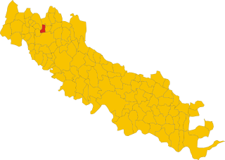
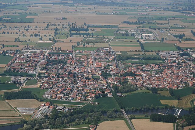
Пьяненго (Pianengo, Pianengo)
.svg)
- коммуна Италии
 Hiking in Пьяненго
Pianengo is a small town in the Lombardy region of Italy, near the Po River, situated within a predominantly flat landscape that offers a different kind of outdoor experience compared to mountainous regions. While it may not be renowned for traditional hiking trails, there are opportunities for hiking and enjoying nature within the surrounding area. Here are some aspects to consider if you're planning a hiking experience near Pianengo:
Local Trails and Parks
-
Cascina Cà Velata: This area offers some rural trails that can be explored on foot. It's a great way to experience the Italian countryside with views of fields, farms, and small woodlands.
-
Parco Regionale Oglio Sud: Just a short drive away, this regional park features a variety of hiking trails that follow the Oglio River. The park is particularly known for its rich biodiversity and offers scenic routes that are perfect for hiking and nature walks.
-
Rural Landscapes: The flat terrain makes for easy hiking experiences suitable for all ages. You’ll encounter charming villages, agricultural fields, and lovely waterways. You might also find designated paths for walking or cycling.
Hiking Tips
- Wear appropriate footwear: Given the nature of trails near Pianengo, comfortable hiking shoes or sturdy walking shoes are recommended.
- Stay hydrated: Always carry water with you, especially if you plan to hike for more than a couple of hours.
- Respect nature and local wildlife: Stick to marked paths to preserve the natural environment and observe any local wildlife responsibly.
Other Activities
Aside from hiking, the area can offer additional activities such as biking, bird watching, and exploring local culture and cuisine. If you have time, consider visiting nearby towns or cities, such as Crema or Lodi, to soak in a bit more of the region's charm.
Conclusion
While Pianengo may not be widely recognized as a hiking destination, it offers a unique experience of walking through picturesque countryside and rural settings. Planning your hikes around the local terrain will help you appreciate the beauty of this lesser-known part of Italy!
- Страна:

- Почтовый код: 26010
- Телефонный код: 0373
- Код автомобильного номера: CR
- Координаты: 45° 24' 0" N, 9° 42' 0" E


- GPS треки (wikiloc): [Ссылка]
- Высота над уровнем моря: 83 м m
- Площадь: 5.76 кв.км
- Население: 2549
- Веб сайт: http://www.comune.pianengo.cr.it/
- Википедия русская: wiki(ru)
- Википедия английская: wiki(en)
- Википедия национальная: wiki(it)
- Хранилище Wikidata: Wikidata: Q43074
- Катеория в википедии: [Ссылка]
- код Freebase: [/m/0gjzj1]
- код GeoNames: Альт: [6543222]
- UN/LOCODE: [ITENG]
- код ISTAT: 019072
- кадастровый код Италии: G558
Граничит с регионами:
Риченго
- коммуна Италии
Hiking in Риченго
Ricengo, a small town in the Lombardy region of Italy, is not widely recognized as a hiking destination. However, its proximity to larger natural attractions in the region offers opportunities for those looking to enjoy hiking in beautiful Italian landscapes....
- Страна:
- Почтовый код: 26010
- Телефонный код: 0373
- Код автомобильного номера: CR
- Координаты: 45° 24' 0" N, 9° 44' 0" E
- GPS треки (wikiloc): [Ссылка]
- Высота над уровнем моря: 86 м m
- Площадь: 12.54 кв.км
- Население: 1757
- Веб сайт: [Ссылка]

Кампаньола-Кремаска
- коммуна Италии
Hiking in Кампаньола-Кремаска
Campagnola Cremasca is a small town located in the Lombardy region of Italy, known for its picturesque landscapes and rural charm. While the area may not be as famous for hiking as some mountainous regions of Italy, there are still opportunities for enjoyable walks and hikes in the surrounding countryside....
- Страна:
- Почтовый код: 26013
- Телефонный код: 0373
- Код автомобильного номера: CR
- Координаты: 45° 24' 0" N, 9° 40' 0" E
- GPS треки (wikiloc): [Ссылка]
- Высота над уровнем моря: 81 м m
- Площадь: 4.64 кв.км
- Население: 686
- Веб сайт: [Ссылка]


Крема
- коммуна Италии
Hiking in Крема
Crema, located in the Lombardy region of northern Italy, is not as widely known for hiking as some of the nearby areas in the Italian Alps or the Apennines. However, it does offer some lovely landscapes and walking trails for those who enjoy a more serene and gentle hiking experience....
- Страна:
- Почтовый код: 26013
- Телефонный код: 0373
- Код автомобильного номера: CR
- Координаты: 45° 22' 0" N, 9° 41' 0" E
- GPS треки (wikiloc): [Ссылка]
- Высота над уровнем моря: 79 м m
- Площадь: 34 кв.км
- Население: 34452
- Веб сайт: [Ссылка]


Казале-Кремаско-Видоласко
- коммуна Италии
Hiking in Казале-Кремаско-Видоласко
Casale Cremasco-Vidolasco is a small town in the Lombardy region of Italy, located not far from the larger city of Cremona. While it may not be a primary destination for hiking enthusiasts, there are opportunities for outdoor activities in the surrounding areas....
- Страна:
- Почтовый код: 26010
- Телефонный код: 0373
- Код автомобильного номера: CR
- Координаты: 45° 25' 55" N, 9° 42' 51" E
- GPS треки (wikiloc): [Ссылка]
- Высота над уровнем моря: 92 м m
- Площадь: 9.19 кв.км
- Население: 1874
- Веб сайт: [Ссылка]

Серньано
- коммуна Италии
Hiking in Серньано
Sergnano is a small town located in the Lombardy region of Italy, near the city of Crema. While it's not widely known as a hiking destination, there are a few opportunities for outdoor activities in and around the area....
- Страна:
- Почтовый код: 26010
- Телефонный код: 0373
- Код автомобильного номера: CR
- Координаты: 45° 26' 0" N, 9° 42' 0" E
- GPS треки (wikiloc): [Ссылка]
- Высота над уровнем моря: 88 м m
- Площадь: 12.31 кв.км
- Население: 3568
- Веб сайт: [Ссылка]