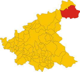
Кампотосто (Campotosto, Campotosto)
.svg)
- коммуна Италии
 Hiking in Кампотосто
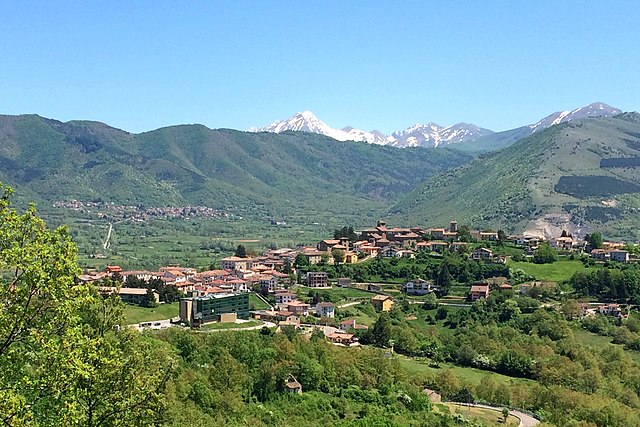
Campotosto is a beautiful area located in the province of Teramo in the Abruzzo region of Italy. It is known for its stunning landscapes, rich biodiversity, and numerous hiking trails that cater to various skill levels. Here are some highlights and information about hiking in Campotosto:
Trail Highlights
-
Gran Sasso and Monti della Laga National Park: Campotosto is situated near this national park, which offers a plethora of trails. The park features rugged mountains, deep valleys, and diverse ecosystems, making it ideal for hiking enthusiasts.
-
Lake Campotosto: This artificial lake is a popular starting point for a variety of hikes. The trails around the lake provide picturesque views and allows for leisurely walks or more challenging routes.
-
Sentiero del Montalto: This trail leads to the summit of Montalto, offering breathtaking panoramic views of the surrounding mountains and valleys. It’s a moderate hike, and the scenery is particularly stunning in spring and autumn.
-
Hiking to the Valle dell'Inferno: This is a more challenging trail that takes you through rugged terrain and offers a glimpse of the region's diverse flora and fauna. The valley is known for its wild beauty and tranquility.
Tips for Hiking in Campotosto
-
Check Weather Conditions: Weather can change rapidly in the mountains, so check forecasts before heading out.
-
Gear Up: Wear proper hiking boots and bring layers to accommodate shifts in temperature, especially if you're hiking at higher elevations.
-
Stay Hydrated and Nourished: Carry enough water and snacks, particularly on longer hikes where amenities may be limited.
-
Follow Trail Markings: Stay on marked trails to preserve the natural environment, and be cautious of your surroundings.
-
Wildlife Awareness: Be mindful of wildlife in the area, and keep a respectful distance.
When to Visit
-
Spring and Autumn: These seasons offer mild temperatures and stunning landscapes with blooming wildflowers in spring and vibrant fall colors.
-
Summer: Ideal for those who enjoy longer days, but higher elevations are preferable due to warmth at lower altitudes.
-
Winter: The region can also be explored in winter, but proper equipment for snow and ice can be necessary, and trails may be more challenging.
Additional Activities
In addition to hiking, Campotosto is known for its culinary delights, especially local cheeses and cured meats, which can enhance your experience after a day on the trails. The region's rich culture and history can also be explored in the small towns and villages nearby.
Overall, hiking in Campotosto offers a unique blend of natural beauty, adventure, and cultural experiences that make for a memorable outing in the Abruzzo region.
- Страна:

- Почтовый код: 67013
- Телефонный код: 0862
- Код автомобильного номера: AQ
- Координаты: 42° 33' 32" N, 13° 22' 5" E


- GPS треки (wikiloc): [Ссылка]
- Высота над уровнем моря: 1420 м m
- Площадь: 51.73 кв.км
- Население: 524
- Веб сайт: http://www.comune.campotosto.aq.it
- Википедия русская: wiki(ru)
- Википедия английская: wiki(en)
- Википедия национальная: wiki(it)
- Хранилище Wikidata: Wikidata: Q50060
- Катеория в википедии: [Ссылка]
- код Freebase: [/m/0fg4dg]
- код GeoNames: Альт: [6538841]
- ID отношения в OpenStreetMap: [42068]
- Google Maps Customer ID: [14679987468019591294]
- код ISTAT: 066016
- кадастровый код Италии: B569
Граничит с регионами:

Аматриче
- коммуна Италии
Hiking in Аматриче
Amatrice, located in the Apennine Mountains of Italy, is a beautiful destination for hiking enthusiasts. The region is known for its stunning landscapes, rich history, and picturesque villages. Here are some key points about hiking in Amatrice:...
- Страна:
- Почтовый код: 02012
- Телефонный код: 0746
- Код автомобильного номера: RI
- Координаты: 42° 37' 46" N, 13° 17' 18" E
- GPS треки (wikiloc): [Ссылка]
- Высота над уровнем моря: 955 м m
- Площадь: 174.4 кв.км
- Население: 2500
- Веб сайт: [Ссылка]


Л’Акуила
- коммуна Италии
Hiking in Л’Акуила
L'Aquila, located in the Abruzzo region of Italy, is surrounded by stunning landscapes, making it a great destination for hiking enthusiasts. The area is characterized by the Gran Sasso and Monti della Laga National Park, which offers a variety of trails suited for all skill levels, from casual walkers to experienced hikers. Here are some highlights of hiking in L'Aquila:...
- Страна:
- Почтовый код: 67100
- Телефонный код: 0862
- Координаты: 42° 21' 14" N, 13° 23' 31" E
- GPS треки (wikiloc): [Ссылка]
- Высота над уровнем моря: 714 м m
- Площадь: 466.87 кв.км
- Население: 69627
- Веб сайт: [Ссылка]


Капитиньяно
- коммуна Италии
Hiking in Капитиньяно
Capitignano is located in the province of L'Aquila in the region of Abruzzo, Italy. It's a less commercialized area compared to some other hiking destinations, making it ideal for those looking to explore nature in a quieter setting. Here are some highlights about hiking in and around Capitignano:...
- Страна:
- Почтовый код: 67014
- Телефонный код: 0862
- Код автомобильного номера: AQ
- Координаты: 42° 31' 13" N, 13° 18' 4" E
- GPS треки (wikiloc): [Ссылка]
- Высота над уровнем моря: 916 м m
- Площадь: 30.64 кв.км
- Население: 662
- Веб сайт: [Ссылка]

Монтереале
- коммуна Италии
Hiking in Монтереале
Montereale, located in the Abruzzo region of central Italy, offers a stunning landscape for hiking enthusiasts. Nestled in the Apennine mountains, this picturesque town is surrounded by rolling hills, lush forests, and breathtaking views, making it an excellent destination for outdoor activities....
- Страна:
- Почтовый код: 67015
- Телефонный код: 0862
- Код автомобильного номера: AQ
- Координаты: 42° 31' 22" N, 13° 14' 55" E
- GPS треки (wikiloc): [Ссылка]
- Высота над уровнем моря: 945 м m
- Площадь: 104.42 кв.км
- Население: 2483
- Веб сайт: [Ссылка]

Кроньалето
- коммуна Италии
Hiking in Кроньалето
Crognaleto is a picturesque area located in the Abruzzo region of Italy, known for its stunning natural landscapes, beautiful mountains, and a variety of hiking trails that cater to different skill levels. The region is part of the Gran Sasso e Monti della Laga National Park, which provides a rich environment of biodiversity, including picturesque valleys, rugged peaks, and diverse flora and fauna....
- Страна:
- Почтовый код: 64043
- Телефонный код: 0861
- Код автомобильного номера: TE
- Координаты: 42° 35' 0" N, 13° 29' 0" E
- GPS треки (wikiloc): [Ссылка]
- Высота над уровнем моря: 835 м m
- Площадь: 124.3 кв.км
- Население: 1245
- Веб сайт: [Ссылка]