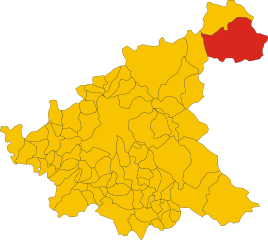
Кроньалето (Crognaleto, Crognaleto)
.svg)
- коммуна Италии
 Hiking in Кроньалето
Crognaleto is a picturesque area located in the Abruzzo region of Italy, known for its stunning natural landscapes, beautiful mountains, and a variety of hiking trails that cater to different skill levels. The region is part of the Gran Sasso e Monti della Laga National Park, which provides a rich environment of biodiversity, including picturesque valleys, rugged peaks, and diverse flora and fauna.
Hiking in Crognaleto:
-
Scenic Trails: The trails in Crognaleto offer breathtaking views of the surrounding mountains and valleys. You can expect a mix of serene forest paths, challenging mountain routes, and panoramic vistas.
-
Difficulty Levels: There are trails suitable for various skill levels, from easy walks for beginners and families to more challenging hikes for seasoned adventurers. Be sure to choose a route that matches your fitness level and experience.
-
Wildlife and Nature: While hiking, you may encounter various wildlife, including deer, wolves, and a wide range of bird species. The diverse landscape also boasts lush forests and beautiful alpine meadows.
-
Best Time to Hike: The spring and autumn months (April to June and September to October) are ideal for hiking in Crognaleto as the weather is typically mild, and the scenery is particularly vibrant during these seasons. The summer months can also be lovely, but be prepared for heat.
-
Gear and Preparation: Proper hiking gear is essential. Ensure you have sturdy hiking boots, weather-appropriate clothing, plenty of water, and snacks. A map or GPS device can be helpful for navigation, especially on less-traveled paths.
-
Local Guidance: Consider joining guided hikes or tours offered by local outdoor companies. This can enhance your experience with knowledgeable insights into the history, culture, and ecology of the area.
-
Cultural Sites: In addition to hiking, Crognaleto offers opportunities to explore local culture and history, including charming villages, historical churches, and traditional cuisine to fuel your adventures.
Always check local regulations and trail conditions before heading out, and remember to follow Leave No Trace principles to protect this beautiful natural environment. Happy hiking!
- Страна:

- Почтовый код: 64043
- Телефонный код: 0861
- Код автомобильного номера: TE
- Координаты: 42° 35' 0" N, 13° 29' 0" E


- GPS треки (wikiloc): [Ссылка]
- Высота над уровнем моря: 835 м m
- Площадь: 124.3 кв.км
- Население: 1245
- Веб сайт: http://www.cmgransasso.it/crognaleto/
- Википедия русская: wiki(ru)
- Википедия английская: wiki(en)
- Википедия национальная: wiki(it)
- Хранилище Wikidata: Wikidata: Q51447
- Катеория в википедии: [Ссылка]
- код Freebase: [/m/0fs43_]
- код GeoNames: Альт: [6536352]
- ID отношения в OpenStreetMap: [42069]
- код ISTAT: 067023
- кадастровый код Италии: D179
Граничит с регионами:

Аматриче
- коммуна Италии
Hiking in Аматриче
Amatrice, located in the Apennine Mountains of Italy, is a beautiful destination for hiking enthusiasts. The region is known for its stunning landscapes, rich history, and picturesque villages. Here are some key points about hiking in Amatrice:...
- Страна:
- Почтовый код: 02012
- Телефонный код: 0746
- Код автомобильного номера: RI
- Координаты: 42° 37' 46" N, 13° 17' 18" E
- GPS треки (wikiloc): [Ссылка]
- Высота над уровнем моря: 955 м m
- Площадь: 174.4 кв.км
- Население: 2500
- Веб сайт: [Ссылка]


Л’Акуила
- коммуна Италии
Hiking in Л’Акуила
L'Aquila, located in the Abruzzo region of Italy, is surrounded by stunning landscapes, making it a great destination for hiking enthusiasts. The area is characterized by the Gran Sasso and Monti della Laga National Park, which offers a variety of trails suited for all skill levels, from casual walkers to experienced hikers. Here are some highlights of hiking in L'Aquila:...
- Страна:
- Почтовый код: 67100
- Телефонный код: 0862
- Координаты: 42° 21' 14" N, 13° 23' 31" E
- GPS треки (wikiloc): [Ссылка]
- Высота над уровнем моря: 714 м m
- Площадь: 466.87 кв.км
- Население: 69627
- Веб сайт: [Ссылка]


Кампотосто
- коммуна Италии
Hiking in Кампотосто
Campotosto is a beautiful area located in the province of Teramo in the Abruzzo region of Italy. It is known for its stunning landscapes, rich biodiversity, and numerous hiking trails that cater to various skill levels. Here are some highlights and information about hiking in Campotosto:...
- Страна:
- Почтовый код: 67013
- Телефонный код: 0862
- Код автомобильного номера: AQ
- Координаты: 42° 33' 32" N, 13° 22' 5" E
- GPS треки (wikiloc): [Ссылка]
- Высота над уровнем моря: 1420 м m
- Площадь: 51.73 кв.км
- Население: 524
- Веб сайт: [Ссылка]

Кортино
- коммуна Италии
Hiking in Кортино
Cortino, located in the province of Teramo in the Abruzzo region of Italy, is surrounded by beautiful natural landscapes, making it a great destination for hiking enthusiasts. The area is characterized by its stunning mountainous terrain, lush forests, and picturesque views of the Gran Sasso d'Italia and the Monti della Laga....
- Страна:
- Почтовый код: 64040
- Телефонный код: 0861
- Код автомобильного номера: TE
- Координаты: 42° 37' 19" N, 13° 30' 28" E
- GPS треки (wikiloc): [Ссылка]
- Высота над уровнем моря: 892 м m
- Площадь: 62.95 кв.км
- Население: 631
- Веб сайт: [Ссылка]

Фано-Абриано
- коммуна Италии
Hiking in Фано-Абриано
Fano Adriano, a small town in the Abruzzo region of Italy, offers a picturesque setting for hikers seeking to explore the natural beauty of the area. Nestled in the Gran Sasso and Monti della Laga National Park, this region boasts a variety of hiking trails suited for different skill levels, from leisurely walks to more challenging treks....
- Страна:
- Почтовый код: 64044
- Телефонный код: 0861
- Код автомобильного номера: TE
- Координаты: 42° 33' 14" N, 13° 32' 12" E
- GPS треки (wikiloc): [Ссылка]
- Высота над уровнем моря: 745 м m
- Площадь: 35.77 кв.км
- Население: 278
- Веб сайт: [Ссылка]
Монторио-аль-Вомано
- коммуна Италии
Hiking in Монторио-аль-Вомано
Montorio al Vomano is a charming town located in the Abruzzo region of Italy, surrounded by beautiful landscapes that make it an excellent destination for hiking enthusiasts. The area features a mix of mountainous terrain, lush forests, and scenic views, making it ideal for both casual hikers and more experienced trekkers....
- Страна:
- Почтовый код: 64046
- Телефонный код: 0861
- Код автомобильного номера: TE
- Координаты: 42° 35' 0" N, 13° 38' 0" E
- GPS треки (wikiloc): [Ссылка]
- Высота над уровнем моря: 262 м m
- Площадь: 53.57 кв.км
- Население: 8013
- Веб сайт: [Ссылка]