
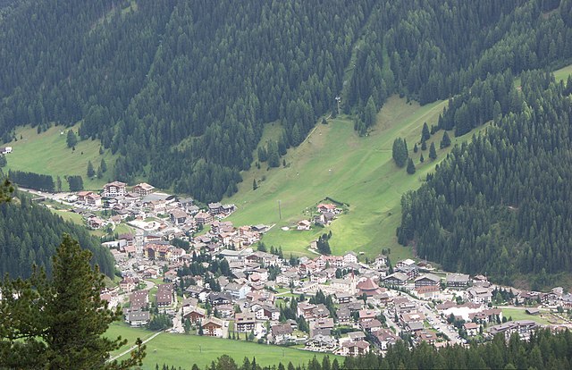
Канацеи (Canazei, Canazei)
%202018.svg)
- коммуна Италии
 Hiking in Канацеи
Canazei, located in the Trentino-Alto Adige region of northern Italy, is a popular destination for hiking enthusiasts thanks to its stunning Dolomite mountain scenery and extensive network of trails. Here are some key points to consider when planning a hiking trip to Canazei:
1.
- The Dolomites, a UNESCO World Heritage site, offer breathtaking views and dramatic landscapes. You'll find towering peaks, lush valleys, and picturesque alpine meadows.
2.
- Beginner to Advanced: Canazei offers a range of hiking trails suitable for all levels, from leisurely walks to challenging hikes.
- Family-friendly Options: There are easy trails that are suitable for families and beginners, often with beautiful scenery.
3.
- Vial d'Fanes: A scenic trail that leads through beautiful landscapes and offers views of several mountain peaks.
- Piz Boè: A challenging hike that rewards you with panoramic views from the top.
- Val di Fassa: Explore the beautiful valley trails, which are generally easier and perfect for a pleasant day hike.
4.
- Summer: Ideal for hiking, biking, and climbing. The trails are well-marked and maintained.
- Winter: Canazei is also a hub for skiing and snowshoeing in the winter months, with excellent routes for winter hiking as well.
5.
- Consider joining a guided tour if you're unfamiliar with the area or want to learn more about the local flora, fauna, and geology. Many local companies offer guided hiking excursions.
6.
- Accommodation: Canazei has a range of accommodation options, from hotels to alpine lodges, catering to different budgets.
- Restaurants: Enjoy local cuisine and traditional Tyrolean dishes in the village after a day of hiking.
7.
- Gear: Ensure you have appropriate hiking gear, including sturdy boots, weather-appropriate clothing, and plenty of water.
- Maps and Navigation: It's essential to have a map or GPS device, as some areas may not have full mobile service.
- Know Your Limits: Be aware of your physical limits and choose trails that suit your experience level.
8.
- The best hiking conditions are generally from late spring (June) to early fall (September), when trails are fully accessible and the weather is milder.
Hiking in Canazei is a remarkable experience that allows you to immerse yourself in nature while enjoying the stunning backdrop of the Dolomites. Whether you're seeking adventure or a peaceful retreat, there's something for everyone in this beautiful region.
- Страна:

- Почтовый код: 38032
- Телефонный код: 0462
- Код автомобильного номера: TN
- Координаты: 46° 28' 37" N, 11° 46' 16" E


- GPS треки (wikiloc): [Ссылка]
- Высота над уровнем моря: 1842 м m
- Площадь: 67.3 кв.км
- Население: 1829
- Веб сайт: http://www.comune.canazei.tn.it
- Википедия русская: wiki(ru)
- Википедия английская: wiki(en)
- Википедия национальная: wiki(it)
- Хранилище Wikidata: Wikidata: Q258031
- Катеория в википедии: [Ссылка]
- код Freebase: [/m/0g9yb9]
- код GeoNames: Альт: [6540227]
- код VIAF: Альт: [245437781]
- ID отношения в OpenStreetMap: [47202]
- код GND: Альт: [4846581-1]
- dmoz: Альт: [Regional/Europe/Italy/Trentino-Alto_Adige/Localities/Canazei/]
- код ISTAT: 022039
- кадастровый код Италии: B579
Граничит с регионами:


Кампителло-ди-Фасса
- коммуна Италии
Hiking in Кампителло-ди-Фасса
Campitello di Fassa, located in the Dolomites in northern Italy, is a picturesque destination for hiking enthusiasts. Surrounded by stunning mountain landscapes, lush forests, and vibrant meadows, it offers a variety of trails suitable for hikers of all skill levels....
- Страна:
- Почтовый код: 38031
- Телефонный код: 0462
- Код автомобильного номера: TN
- Координаты: 46° 28' 36" N, 11° 44' 28" E
- GPS треки (wikiloc): [Ссылка]
- Высота над уровнем моря: 1448 м m
- Площадь: 25.02 кв.км
- Население: 730
- Веб сайт: [Ссылка]


Маццин
- коммуна Италии
Hiking in Маццин
Mazzin, located in the heart of the Dolomites in Italy, is a fantastic destination for hiking enthusiasts. This charming village is part of the Val di Fassa, surrounded by stunning mountain scenery, vibrant meadows, and a rich cultural heritage....
- Страна:
- Почтовый код: 38030
- Телефонный код: 0462
- Код автомобильного номера: TN
- Координаты: 46° 27' 27" N, 11° 42' 2" E
- GPS треки (wikiloc): [Ссылка]
- Высота над уровнем моря: 1395 м m
- Площадь: 23.63 кв.км
- Население: 564
- Веб сайт: [Ссылка]


Корвара-ин-Бадия
- коммуна в регионе Трентино — Альто-Адидже, Италия
Hiking in Корвара-ин-Бадия
Corvara, located in the heart of the Dolomites in South Tyrol, Italy, is a stunning destination for hiking enthusiasts. Surrounded by dramatic mountain peaks, lush valleys, and picturesque meadows, it offers a wide variety of hiking experiences suitable for all skill levels. Here’s an overview of what you can expect when hiking in Corvara:...
- Страна:
- Почтовый код: 39033
- Телефонный код: 0471
- Код автомобильного номера: BZ
- Координаты: 46° 33' 1" N, 11° 52' 24" E
- GPS треки (wikiloc): [Ссылка]
- Высота над уровнем моря: 1568 м m
- Площадь: 38.92 кв.км
- Население: 1372
- Веб сайт: [Ссылка]


Ливиналлонго-дель-Коль-ди-Лана
- коммуна Италии
Hiking in Ливиналлонго-дель-Коль-ди-Лана
Livinallongo del Col di Lana is a stunning valley located in the Dolomites of northern Italy. It offers a unique combination of breathtaking landscapes, rich history, and a variety of hiking trails that cater to different skill levels....
- Страна:
- Почтовый код: 32020
- Телефонный код: 0436
- Код автомобильного номера: BL
- Координаты: 46° 29' 0" N, 11° 57' 0" E
- GPS треки (wikiloc): [Ссылка]
- Высота над уровнем моря: 1645 м m
- Площадь: 100.01 кв.км
- Население: 1300
- Веб сайт: [Ссылка]


Рокка-Пьеторе
- коммуна Италии
Hiking in Рокка-Пьеторе
Rocca Pietore is a picturesque village located in the Dolomites region of northern Italy. It serves as an excellent base for hikers looking to explore the stunning landscapes, renowned peaks, and vibrant nature of the area. Here are some key highlights and tips for hiking in Rocca Pietore:...
- Страна:
- Почтовый код: 32020
- Телефонный код: 0437
- Код автомобильного номера: BL
- Координаты: 46° 26' 4" N, 11° 58' 38" E
- GPS треки (wikiloc): [Ссылка]
- Высота над уровнем моря: 1143 м m
- Площадь: 73.29 кв.км
- Население: 1203
- Веб сайт: [Ссылка]

Сельва-ди-Валь-Гардена
- коммуна в Италии
Hiking in Сельва-ди-Валь-Гардена
Sëlva, known as Selva di Val Gardena, is a picturesque village located in the Dolomites of northern Italy, particularly popular for its stunning landscapes and diverse hiking trails. The Dolomites are a UNESCO World Heritage site, making hiking in this region an unforgettable experience....
- Страна:
- Почтовый код: 39048
- Телефонный код: 0471
- Код автомобильного номера: BZ
- Координаты: 46° 33' 17" N, 11° 45' 37" E
- GPS треки (wikiloc): [Ссылка]
- Высота над уровнем моря: 1563 м m
- Площадь: 56.24 кв.км
- Население: 2621
- Веб сайт: [Ссылка]