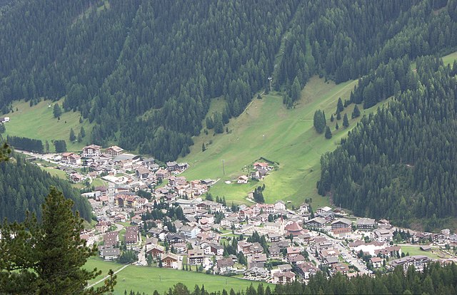
Кампителло-ди-Фасса (Campitello di Fassa, Campitello di Fassa)
%202018.svg)
- коммуна Италии
 Hiking in Кампителло-ди-Фасса
Campitello di Fassa, located in the Dolomites in northern Italy, is a picturesque destination for hiking enthusiasts. Surrounded by stunning mountain landscapes, lush forests, and vibrant meadows, it offers a variety of trails suitable for hikers of all skill levels.
Popular Hiking Routes
-
Col Rodella: A popular starting point, accessible by cable car. From here, you can enjoy panoramic views and embark on trails that lead to higher altitude paths or down to the valley.
-
Val Duron: This trail takes you through beautiful alpine scenery, offering views of the surrounding peaks. It's relatively easy and perfect for families.
-
Sasso Piatto and Sasso Lungo: These iconic mountains have trails that vary in difficulty. A hike around these peaks can include challenges for more experienced hikers or easier paths for casual walkers.
-
Passo Sella: A bit further afield, this area features breathtaking views and a range of trails that connect with other areas in the Dolomiti Superski region.
Recommendations
- Trail Conditions: Always check trail conditions and weather forecasts before heading out, as the Dolomites' weather can change rapidly.
- Gear: Proper hiking gear is crucial. Good hiking boots, weather-appropriate clothing, and a first-aid kit are highly recommended.
- Local Guides: Consider hiring a local guide for a more in-depth understanding of the region's flora, fauna, and geology, as well as navigating the trails.
- Wildlife: Keep an eye out for the diverse wildlife, including chamois, marmots, and various bird species.
Seasonal Considerations
- Summer Hiking: This is the most popular time for hiking, with trails accessible and well-marked.
- Winter Hiking/Snowshoeing: In winter, many trails can be explored with snowshoes or are suitable for winter hiking, but always ensure trails are open and safe.
Conclusion
Hiking in Campitello di Fassa is an unforgettable experience, offering breathtaking natural beauty and a range of trails to explore. Whether you’re looking for a serene walk through nature or a challenging climb, you will find something that suits your needs in this stunning part of the Dolomites. Always remember to leave no trace and respect the natural environment during your hikes!
- Страна:

- Почтовый код: 38031
- Телефонный код: 0462
- Код автомобильного номера: TN
- Координаты: 46° 28' 36" N, 11° 44' 28" E


- GPS треки (wikiloc): [Ссылка]
- Высота над уровнем моря: 1448 м m
- Площадь: 25.02 кв.км
- Население: 730
- Веб сайт: http://www.comune.campitellodifassa.tn.it
- Википедия русская: wiki(ru)
- Википедия английская: wiki(en)
- Википедия национальная: wiki(it)
- Хранилище Wikidata: Wikidata: Q257783
- Катеория в википедии: [Ссылка]
- код Freebase: [/m/0g9y7t]
- код GeoNames: Альт: [6542172]
- ID отношения в OpenStreetMap: [47229]
- код ISTAT: 022036
- кадастровый код Италии: B514
Граничит с регионами:


Канацеи
- коммуна Италии
Hiking in Канацеи
Canazei, located in the Trentino-Alto Adige region of northern Italy, is a popular destination for hiking enthusiasts thanks to its stunning Dolomite mountain scenery and extensive network of trails. Here are some key points to consider when planning a hiking trip to Canazei:...
- Страна:
- Почтовый код: 38032
- Телефонный код: 0462
- Код автомобильного номера: TN
- Координаты: 46° 28' 37" N, 11° 46' 16" E
- GPS треки (wikiloc): [Ссылка]
- Высота над уровнем моря: 1842 м m
- Площадь: 67.3 кв.км
- Население: 1829
- Веб сайт: [Ссылка]


Маццин
- коммуна Италии
Hiking in Маццин
Mazzin, located in the heart of the Dolomites in Italy, is a fantastic destination for hiking enthusiasts. This charming village is part of the Val di Fassa, surrounded by stunning mountain scenery, vibrant meadows, and a rich cultural heritage....
- Страна:
- Почтовый код: 38030
- Телефонный код: 0462
- Код автомобильного номера: TN
- Координаты: 46° 27' 27" N, 11° 42' 2" E
- GPS треки (wikiloc): [Ссылка]
- Высота над уровнем моря: 1395 м m
- Площадь: 23.63 кв.км
- Население: 564
- Веб сайт: [Ссылка]


Кастельротто
- коммуна Италии
Hiking in Кастельротто
Kastelruth, located in the beautiful Dolomites region of northern Italy, is a fantastic destination for hiking enthusiasts. The area is known for its stunning landscapes, diverse trails, and charming alpine villages. Here are some highlights and tips for hiking in Kastelruth:...
- Страна:
- Почтовый код: 39040
- Телефонный код: 0471
- Код автомобильного номера: BZ
- Координаты: 46° 34' 0" N, 11° 33' 40" E
- GPS треки (wikiloc): [Ссылка]
- Высота над уровнем моря: 2958 м m
- Площадь: 117.9 кв.км
- Население: 6872
- Веб сайт: [Ссылка]

Сельва-ди-Валь-Гардена
- коммуна в Италии
Hiking in Сельва-ди-Валь-Гардена
Sëlva, known as Selva di Val Gardena, is a picturesque village located in the Dolomites of northern Italy, particularly popular for its stunning landscapes and diverse hiking trails. The Dolomites are a UNESCO World Heritage site, making hiking in this region an unforgettable experience....
- Страна:
- Почтовый код: 39048
- Телефонный код: 0471
- Код автомобильного номера: BZ
- Координаты: 46° 33' 17" N, 11° 45' 37" E
- GPS треки (wikiloc): [Ссылка]
- Высота над уровнем моря: 1563 м m
- Площадь: 56.24 кв.км
- Население: 2621
- Веб сайт: [Ссылка]


Санта-Кристина-Вальгардена
- коммуна в Италии
Hiking in Санта-Кристина-Вальгардена
Santa Cristina Gherdëina, located in the Dolomites of northern Italy, is a beautiful destination for hiking enthusiasts. The stunning landscape, dramatic peaks, and vibrant alpine scenery provide an incredible backdrop for a variety of hiking trails, suitable for all skill levels. Here are some highlights and tips if you’re considering hiking in this region:...
- Страна:
- Почтовый код: 39047
- Телефонный код: 0471
- Код автомобильного номера: BZ
- Координаты: 46° 33' 47" N, 11° 43' 56" E
- GPS треки (wikiloc): [Ссылка]
- Высота над уровнем моря: 1428 м m
- Площадь: 31.92 кв.км
- Население: 1961
- Веб сайт: [Ссылка]
Тирес
- коммуна в Италии
Hiking in Тирес
Tiers (or Tires) is a charming village located in the Dolomites of South Tyrol, Italy, and offers an abundance of hiking opportunities. Here are some highlights about hiking in that area:...
- Страна:
- Почтовый код: 39050
- Телефонный код: 0471
- Код автомобильного номера: BZ
- Координаты: 46° 28' 5" N, 11° 31' 37" E
- GPS треки (wikiloc): [Ссылка]
- Высота над уровнем моря: 1028 м m
- Площадь: 42.18 кв.км
- Население: 987
- Веб сайт: [Ссылка]