Каноника-д'Адда (Canonica d'Adda, Canonica d'Adda)
.svg)
- коммуна Италии
 Hiking in Каноника-д'Адда
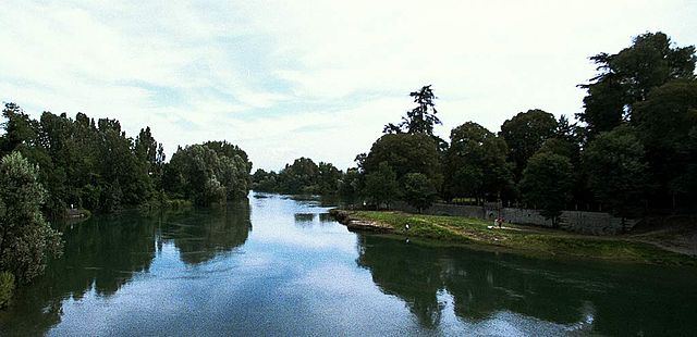
Canonica d'Adda is a picturesque town located in the Lombardy region of Italy, along the banks of the Adda River. It offers a number of beautiful trails and scenic vistas for hiking enthusiasts. Here’s what you should know about hiking in this area:
Trails and Scenery:
-
Adda River Path: One of the most popular routes is the path that follows the Adda River. This trail allows hikers to enjoy beautiful riverside views, nature, and opportunities for birdwatching. The trail is generally flat and suitable for all skill levels.
-
Parco Adda Nord: A short distance from Canonica d'Adda is Parco Adda Nord, a regional park that features a variety of trails through lush woodlands, meadows, and along the river. The park has well-marked paths for hiking and is a great place to experience the local flora and fauna.
-
Historical Sites: Along the hiking routes, you may come across historical sites, such as old mills and charming villages, providing insights into the region’s rich history and culture.
Suitable for All Levels:
The hiking routes in and around Canonica d'Adda cater to all levels of hikers, from beginners to more experienced trekkers. Many trails are well-maintained and marked, making navigation easy.
Preparation:
- Footwear: Wear sturdy hiking shoes to ensure comfort on various terrains.
- Water and Snacks: Be sure to carry sufficient water and snacks to stay energized during your hike.
- Weather: Check the weather forecast before heading out, as conditions can change rapidly.
Recommendations:
- Best Time to Hike: Spring and autumn are usually the best times to hike in this area, offering mild temperatures and beautiful scenery.
- Local Maps and Guides: Consider getting a local hiking map or joining a guided tour for the best experience.
Overall, hiking in Canonica d'Adda offers a delightful experience with its natural beauty, rich history, and accessibility. Enjoy your hike!
- Страна:

- Почтовый код: 24040
- Телефонный код: 02
- Код автомобильного номера: BG
- Координаты: 45° 34' 31" N, 9° 32' 20" E


- GPS треки (wikiloc): [Ссылка]
- Высота над уровнем моря: 99 м m
- Площадь: 3.21 кв.км
- Население: 4504
- Веб сайт: http://www.comune.canonicadadda.bg.it
- Википедия русская: wiki(ru)
- Википедия английская: wiki(en)
- Википедия национальная: wiki(it)
- Хранилище Wikidata: Wikidata: Q100135
- Галерея изображений в википедии: [Ссылка]
- Катеория в википедии: [Ссылка]
- код Freebase: [/m/0gj93c]
- код GeoNames: Альт: [6542553]
- код VIAF: Альт: [245816246]
- ID отношения в OpenStreetMap: [45356]
- UN/LOCODE: [ITKDA]
- код Цифрового атласа Римской империи: [17143]
- код Pleiades: [383747]
- код ISTAT: 016049
- кадастровый код Италии: B618
Граничит с регионами:


Каприате-Сан-Джервазио
- коммуна Италии
Hiking in Каприате-Сан-Джервазио
Capriate San Gervasio, located in the Lombardy region of northern Italy, offers a variety of outdoor activities, including hiking. This area is not as well-known for hiking compared to other regions in Italy, but it can still provide pleasant nature walks and scenic routes for those looking to explore the local landscape....
- Страна:
- Почтовый код: 24042
- Телефонный код: 02
- Код автомобильного номера: BG
- Координаты: 45° 36' 32" N, 9° 31' 41" E
- GPS треки (wikiloc): [Ссылка]
- Высота над уровнем моря: 188 м m
- Площадь: 5.83 кв.км
- Население: 8173
- Веб сайт: [Ссылка]


Фара-Джера-д'Адда
- коммуна Италии
Hiking in Фара-Джера-д'Адда
Fara Gera d'Adda is a charming town located in the Lombardy region of Italy, near the Adda River. While it may not be as well-known as some larger hiking destinations, it offers a variety of outdoor activities and scenic trails that can be appealing to hikers....
- Страна:
- Почтовый код: 24045
- Телефонный код: 0363
- Код автомобильного номера: BG
- Координаты: 45° 33' 0" N, 9° 32' 0" E
- GPS треки (wikiloc): [Ссылка]
- Высота над уровнем моря: 131 м m
- Площадь: 10.79 кв.км
- Население: 8043
- Веб сайт: [Ссылка]


Понтироло-Нуово
- коммуна Италии
Hiking in Понтироло-Нуово
Pontirolo Nuovo, a small town in the Lombardy region of Italy, is not specifically known as a hiking destination, but it is surrounded by a countryside that offers some opportunities for walking and outdoor activities. Here are some suggestions and information relevant to hiking in and around Pontirolo Nuovo:...
- Страна:
- Почтовый код: 24040
- Телефонный код: 0363
- Код автомобильного номера: BG
- Координаты: 45° 34' 9" N, 9° 34' 2" E
- GPS треки (wikiloc): [Ссылка]
- Высота над уровнем моря: 155 м m
- Площадь: 11.1 кв.км
- Население: 4983
- Веб сайт: [Ссылка]

Ваприо-д'Адда
- коммуна Италии
Hiking in Ваприо-д'Адда
Vaprio d'Adda is a charming town located in the Lombardy region of Italy, situated along the Adda River. It's an excellent destination for hiking enthusiasts due to its picturesque landscapes and natural beauty. Here are some key points about hiking in the area:...
- Страна:
- Почтовый код: 20069
- Телефонный код: 02
- Код автомобильного номера: MI
- Координаты: 45° 34' 0" N, 9° 32' 0" E
- GPS треки (wikiloc): [Ссылка]
- Высота над уровнем моря: 161 м m
- Площадь: 7.15 кв.км
- Население: 8972
- Веб сайт: [Ссылка]


Брембате
- коммуна Италии
Hiking in Брембате
Brembate, located in the province of Bergamo, Italy, is surrounded by beautiful landscapes that offer a variety of hiking opportunities. The area combines natural beauty with historical sites, making it a great destination for both casual hikers and more serious outdoor enthusiasts....
- Страна:
- Почтовый код: 24041
- Телефонный код: 035
- Код автомобильного номера: BG
- Координаты: 45° 36' 0" N, 9° 33' 0" E
- GPS треки (wikiloc): [Ссылка]
- Высота над уровнем моря: 173 м m
- Площадь: 5.54 кв.км
- Население: 8551
- Веб сайт: [Ссылка]