Каприате-Сан-Джервазио (Capriate San Gervasio, Capriate San Gervasio)
.svg)
- коммуна Италии
 Hiking in Каприате-Сан-Джервазио
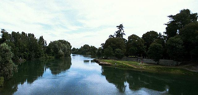
Capriate San Gervasio, located in the Lombardy region of northern Italy, offers a variety of outdoor activities, including hiking. This area is not as well-known for hiking compared to other regions in Italy, but it can still provide pleasant nature walks and scenic routes for those looking to explore the local landscape.
Hiking Opportunities:
-
Natural Reserves: Nearby natural reserves such as the Parco del Serio offer trails that can be explored on foot. The park features lush greenery and a peaceful environment, making it suitable for leisurely hikes and picnics.
-
Riverside Trails: The area around the Adda River may have trails that allow hikers to enjoy the riverside views. These trails can provide opportunities for wildlife observation and enjoying the surrounding nature.
-
Exploring Local Hills: While not mountainous, there may be gentle hills surrounding the town that can provide short hikes and local exploration.
Recommended Tips:
- Preparation: Before heading out, ensure you have adequate maps or a GPS device, as some paths might not be well-marked.
- Timing: The best time for hiking is during the spring and early autumn when temperatures are mild and the scenery is vibrant.
- Gear: Wear comfortable hiking boots and bring water, snacks, and a first-aid kit.
Local Attractions:
- Historical Sites: While you’re hiking, consider visiting some of the local historical landmarks in Capriate San Gervasio, such as the famous Santuario di S. Maria Assunta.
- Cultural Experiences: Engage with the local culture by trying regional foods or participating in any local events that might be happening during your visit.
Conclusion:
While Capriate San Gervasio may not be a hiking hotspot, it offers an opportunity to enjoy nature and explore the Lombardy region's scenic beauty. Combining hiking with cultural visits can make for a well-rounded experience. If you seek more challenging hikes or extensive trail systems, consider exploring nearby regions such as the Orobian Alps or the Brianza area.
- Страна:

- Почтовый код: 24042
- Телефонный код: 02
- Код автомобильного номера: BG
- Координаты: 45° 36' 32" N, 9° 31' 41" E


- GPS треки (wikiloc): [Ссылка]
- Высота над уровнем моря: 188 м m
- Площадь: 5.83 кв.км
- Население: 8173
- Веб сайт: http://www.comune.capriate-san-gervasio.bg.it
- Википедия русская: wiki(ru)
- Википедия английская: wiki(en)
- Википедия национальная: wiki(it)
- Хранилище Wikidata: Wikidata: Q100141
- Галерея изображений в википедии: [Ссылка]
- Катеория в википедии: [Ссылка]
- код Freebase: [/m/049rn6]
- код GeoNames: Альт: [6539620]
- код VIAF: Альт: [243197342]
- ID отношения в OpenStreetMap: [45420]
- UN/LOCODE: [ITCPI]
- код ISTAT: 016051
- кадастровый код Италии: B703
Граничит с регионами:


Каноника-д'Адда
- коммуна Италии
Hiking in Каноника-д'Адда
Canonica d'Adda is a picturesque town located in the Lombardy region of Italy, along the banks of the Adda River. It offers a number of beautiful trails and scenic vistas for hiking enthusiasts. Here’s what you should know about hiking in this area:...
- Страна:
- Почтовый код: 24040
- Телефонный код: 02
- Код автомобильного номера: BG
- Координаты: 45° 34' 31" N, 9° 32' 20" E
- GPS треки (wikiloc): [Ссылка]
- Высота над уровнем моря: 99 м m
- Площадь: 3.21 кв.км
- Население: 4504
- Веб сайт: [Ссылка]


Филаго
- коммуна Италии
Hiking in Филаго
Filago, located in the Lombardy region of Italy, offers a serene experience for hikers looking to explore the picturesque landscapes of Northern Italy. While it may not be as widely known as some other hiking destinations, it is surrounded by beautiful natural areas and charming villages that enhance the hiking experience....
- Страна:
- Почтовый код: 24040
- Телефонный код: 035
- Код автомобильного номера: BG
- Координаты: 45° 38' 0" N, 9° 33' 0" E
- GPS треки (wikiloc): [Ссылка]
- Высота над уровнем моря: 190 м m
- Площадь: 5.42 кв.км
- Население: 3182
- Веб сайт: [Ссылка]

Ваприо-д'Адда
- коммуна Италии
Hiking in Ваприо-д'Адда
Vaprio d'Adda is a charming town located in the Lombardy region of Italy, situated along the Adda River. It's an excellent destination for hiking enthusiasts due to its picturesque landscapes and natural beauty. Here are some key points about hiking in the area:...
- Страна:
- Почтовый код: 20069
- Телефонный код: 02
- Код автомобильного номера: MI
- Координаты: 45° 34' 0" N, 9° 32' 0" E
- GPS треки (wikiloc): [Ссылка]
- Высота над уровнем моря: 161 м m
- Площадь: 7.15 кв.км
- Население: 8972
- Веб сайт: [Ссылка]


Треццо-сулл'Адда
- коммуна Италии
Hiking in Треццо-сулл'Адда
Trezzo sull'Adda is a charming town located in Lombardy, Italy, along the Adda River. It offers a variety of hiking opportunities that showcase the natural beauty of the area and its historical significance. Here are some highlights for hiking in and around Trezzo sull'Adda:...
- Страна:
- Почтовый код: 20056
- Телефонный код: 02
- Код автомобильного номера: MI
- Координаты: 45° 36' 0" N, 9° 31' 0" E
- GPS треки (wikiloc): [Ссылка]
- Высота над уровнем моря: 187 м m
- Площадь: 13.05 кв.км
- Население: 12102
- Веб сайт: [Ссылка]


Боттануко
- коммуна Италии
Hiking in Боттануко
Bottanuco is a small town in the province of Bergamo, Lombardy, Italy, which serves as a gateway to the beautiful landscapes of the surrounding region. Hiking around Bottanuco offers a blend of scenic views, cultural experiences, and varying difficulty levels. Here are some key points to consider about hiking in Bottanuco:...
- Страна:
- Почтовый код: 24040
- Телефонный код: 035
- Код автомобильного номера: BG
- Координаты: 45° 38' 23" N, 9° 30' 23" E
- GPS треки (wikiloc): [Ссылка]
- Высота над уровнем моря: 222 м m
- Площадь: 5.77 кв.км
- Население: 5137
- Веб сайт: [Ссылка]


Брембате
- коммуна Италии
Hiking in Брембате
Brembate, located in the province of Bergamo, Italy, is surrounded by beautiful landscapes that offer a variety of hiking opportunities. The area combines natural beauty with historical sites, making it a great destination for both casual hikers and more serious outdoor enthusiasts....
- Страна:
- Почтовый код: 24041
- Телефонный код: 035
- Код автомобильного номера: BG
- Координаты: 45° 36' 0" N, 9° 33' 0" E
- GPS треки (wikiloc): [Ссылка]
- Высота над уровнем моря: 173 м m
- Площадь: 5.54 кв.км
- Население: 8551
- Веб сайт: [Ссылка]