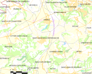
Эрьё (кантон) (canton of Heyrieux, canton d'Heyrieux)
 Hiking in Эрьё (кантон)
Canton d'Heyrieux, located in the Auvergne-Rhône-Alpes region of France, is a beautiful area for hiking enthusiasts. This canton is characterized by its diverse landscapes, including rolling hills, forests, and charming villages, making it a great destination for various hiking experiences.
Key Features for Hiking in Canton d'Heyrieux:
-
Scenic Trails: The canton has a variety of marked hiking trails ranging from easy walks suitable for families to more challenging hikes for experienced trekkers. The paths often provide stunning views of the surrounding countryside.
-
Natural Flora and Fauna: As you hike, you may encounter diverse wildlife and plant species native to the region. These areas are often rich in biodiversity, which can make for an interesting hiking experience.
-
Cultural Landmarks: Hiking routes may take you past local heritage sites, including historical buildings and sites of interest that reflect the region's history and culture.
-
Accessibility: The canton is relatively close to larger urban centers like Lyon, making it an accessible destination for day trips or weekend hikes.
-
Local Amenities: Many villages in the canton offer amenities such as local eateries and shops, where you can replenish energy with regional delicacies.
Tips for Hiking in Canton d'Heyrieux:
-
Trail Maps: Always carry a map or use a navigation app to ensure you stay on track. Local tourist offices may provide trail maps and additional information.
-
Proper Gear: Wear comfortable hiking shoes and dress in layers, as the weather can change quickly in mountainous regions.
-
Check Local Guidelines: Before heading out, check for any local guidelines or trail conditions, especially during the wet season or after heavy snowfall.
-
Stay Hydrated: Bring sufficient water and snacks, particularly for longer hikes, as facilities may be sparse along certain trails.
-
Respect Nature: Follow Leave No Trace principles by packing out what you bring in and staying on marked trails to protect the environment.
Enjoy your hiking in Canton d'Heyrieux! It’s a perfect place to explore nature and appreciate the beauty of the Auvergne-Rhône-Alpes region.
- Страна:

- Столица: Эрьё
- Координаты: 45° 35' 30" N, 5° 3' 27" E


- GPS треки (wikiloc): [Ссылка]
- Хранилище Wikidata: Wikidata: Q628133
- код кантона INSEE: [3815]
Включает регионы:

Сен-Жорж-д'Эсперанш
- коммуна во Франции
Hiking in Сен-Жорж-д'Эсперанш
Saint-Georges-d'Espéranche is a charming commune located in the Isère department of the Auvergne-Rhône-Alpes region in southeastern France. While it may not be as widely known as some other hiking destinations in the region, it offers a range of outdoor activities and scenic landscapes that are perfect for hiking enthusiasts....
- Страна:
- Почтовый код: 38790
- Координаты: 45° 33' 21" N, 5° 4' 39" E
- GPS треки (wikiloc): [Ссылка]
- Площадь: 24.65 кв.км
- Население: 3321
- Веб сайт: [Ссылка]


Сен-Жюст-Шалессен
- коммуна во Франции
Hiking in Сен-Жюст-Шалессен
Saint-Just-Chaleyssin is a charming commune located in the Isère department of the Auvergne-Rhône-Alpes region in southeastern France. It offers various opportunities for hiking enthusiasts through scenic landscapes that showcase the beauty of both the natural environment and the local countryside....
- Страна:
- Почтовый код: 38540
- Координаты: 45° 35' 6" N, 4° 59' 57" E
- GPS треки (wikiloc): [Ссылка]
- Площадь: 13.95 кв.км
- Население: 2468
- Веб сайт: [Ссылка]


Уатье-Сент-Обла
- коммуна во Франции
Hiking in Уатье-Сент-Обла
Oytier-Saint-Oblas, situated in the Auvergne-Rhône-Alpes region of southeastern France, offers beautiful landscapes and a variety of hiking opportunities. Here are some key points to consider if you're planning to hike in this area:...
- Страна:
- Почтовый код: 38780
- Координаты: 45° 33' 40" N, 5° 1' 15" E
- GPS треки (wikiloc): [Ссылка]
- Площадь: 14.3 кв.км
- Население: 1621
- Веб сайт: [Ссылка]


Шарантонне
Hiking in Шарантонне
Charantonnay is a charming municipality located in the Auvergne-Rhône-Alpes region of France, which is known for its beautiful landscapes and outdoor activities. Although it's a smaller village, it offers access to some lovely hiking opportunities in the surrounding areas. Here are some key points to consider for hiking in and around Charantonnay:...
- Страна:
- Почтовый код: 38790
- Координаты: 45° 32' 13" N, 5° 6' 29" E
- GPS треки (wikiloc): [Ссылка]
- Площадь: 11 кв.км
- Население: 1853
- Веб сайт: [Ссылка]


Дьемоз
- коммуна во Франции
Hiking in Дьемоз
Diémoz is a charming commune located in the Auvergne-Rhône-Alpes region of France, near Lyon. Although it's not as widely known for trekking as some of the larger national parks or mountainous areas, it offers opportunities for hiking and enjoying the natural beauty of the surrounding countryside....
- Страна:
- Почтовый код: 38790
- Координаты: 45° 35' 19" N, 5° 5' 39" E
- GPS треки (wikiloc): [Ссылка]
- Площадь: 13.72 кв.км
- Население: 2672


Грене
Hiking in Грене
Grenay, located in the Isère department of the Auvergne-Rhône-Alpes region in France, offers beautiful landscapes and a variety of hiking options. While Grenay itself is a smaller town, it is well-positioned for access to the surrounding natural beauty of the region....
- Страна:
- Почтовый код: 38540
- Координаты: 45° 39' 52" N, 5° 4' 46" E
- GPS треки (wikiloc): [Ссылка]
- Площадь: 7.2 кв.км
- Население: 1586
- Веб сайт: [Ссылка]


Валансен
- коммуна во Франции
Hiking in Валансен
Valencin is a charming village located in the Auvergne-Rhône-Alpes region of France, near the city of Lyon. The area offers a variety of hiking opportunities suitable for all skill levels, with routes that cater to both beginners and experienced hikers....
- Страна:
- Почтовый код: 38540
- Координаты: 45° 36' 43" N, 5° 0' 53" E
- GPS треки (wikiloc): [Ссылка]
- Площадь: 9.63 кв.км
- Население: 2713
- Веб сайт: [Ссылка]


Эрьё
- коммуна во Франции
Hiking in Эрьё
Heyrieux is located in the Auvergne-Rhône-Alpes region of southeastern France, near the city of Lyon. While it may not be as renowned as some other hiking destinations, there are certainly opportunities for outdoor enthusiasts in and around the area....
- Страна:
- Почтовый код: 38540
- Координаты: 45° 37' 45" N, 5° 3' 48" E
- GPS треки (wikiloc): [Ссылка]
- Площадь: 13.95 кв.км
- Население: 4650
- Веб сайт: [Ссылка]