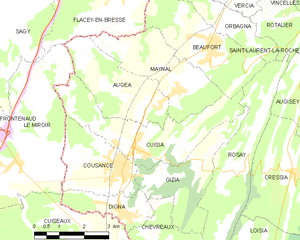
canton of Beaufort (canton de Beaufort)
 Hiking in canton of Beaufort
Canton de Beaufort in the Jura region of France is a beautiful and serene area ideal for hiking enthusiasts. Known for its stunning landscapes, rolling hills, dense forests, and panoramic views, this canton offers a variety of trails suitable for all skill levels.
Key Highlights:
-
Scenic Views: The trails often provide breathtaking views of the surrounding Jura mountains, lush valleys, and picturesque villages. Don't forget to bring your camera to capture the stunning landscape.
-
Trail Variety: There are numerous hiking routes with varying difficulty levels. Whether you’re looking for a leisurely walk or a challenging trek, you’ll find options that suit your fitness level. Trails range from short paths suitable for families to longer, more strenuous hikes for seasoned hikers.
-
Wildlife and Flora: The Jura region is rich in biodiversity. Hikers can spot various wildlife, including deer, foxes, and a wide range of bird species. The flora is equally diverse, with beautiful wildflowers and ancient trees lining the paths.
-
Cultural Sites: Along the hiking routes, you may come across charming villages, historical sites, and traditional Jura architecture. Taking the time to explore these areas can greatly enrich your hiking experience.
-
Seasonal Hiking: Each season brings a different charm to the trails. Spring and summer are ideal for wildflower viewing, while fall offers stunning foliage. Winter hiking is also popular, with opportunities for snowshoeing and winter walks.
Important Tips:
- Trail Maps: Make sure to have a trail map or use a hiking app, as trail markings can vary, and some paths might be less frequented.
- Safety Gear: Bring appropriate hiking gear, including sturdy footwear, weather-appropriate clothing, and a first-aid kit.
- Hydration and Snacks: Carry enough water and snacks, especially on longer hikes, as amenities might be sparse in some areas.
- Respect Nature: Stay on marked trails, avoid disturbing wildlife, and leave no trace to preserve the natural beauty for future hikers.
Recommended Trails:
- Le Sentier des Vignes: A gentle trail winding through vineyards with stunning views of the surrounding countryside.
- Les Crêts: A more challenging path that offers panoramic views of the Jura mountain range.
- La Cascade de La Billaude: A scenic hike leading to a beautiful waterfall, perfect for a picnic spot.
Accessibility:
Most trails in the Canton de Beaufort are accessible by car, with parking available at trailheads. Public transportation options may also be available for those coming from nearby towns.
In summary, hiking in Canton de Beaufort offers a mix of natural beauty, cultural experiences, and outdoor adventure. Whether you're looking for a peaceful nature walk or a rigorous trek, this region won't disappoint. Happy hiking!
- Страна:

- Столица: Beaufort
- Координаты: 46° 34' 0" N, 5° 26' 0" E


- GPS треки (wikiloc): [Ссылка]
- Хранилище Wikidata: Wikidata: Q1472755
- код кантона INSEE: [3903]
Включает регионы:


Augisey
- коммуна во Франции
Hiking in Augisey
It seems there might be a typographical error in "Augisey," as it doesn't correspond to a well-known hiking destination. However, if you meant "Augisey," it’s possible you’re referring to a location that may not be widely recognized or perhaps it is a lesser-known trail or region....
- Страна:
- Почтовый код: 39270
- Координаты: 46° 33' 11" N, 5° 29' 33" E
- GPS треки (wikiloc): [Ссылка]
- Площадь: 9.29 кв.км
- Население: 217

Cuisia
- коммуна во Франции
Hiking in Cuisia
Cuisia is a lesser-known but beautiful destination for hiking, particularly favored for its natural landscapes and well-preserved trails. While it may not have the extensive infrastructure of more famous hiking areas, it offers a range of experiences suited for different skill levels. Here are some key aspects to consider when hiking in Cuisia:...
- Страна:
- Почтовый код: 39190
- Координаты: 46° 32' 15" N, 5° 24' 8" E
- GPS треки (wikiloc): [Ссылка]
- Высота над уровнем моря: 230 м m
- Площадь: 10.16 кв.км
- Население: 394


Gizia
- коммуна во Франции
Hiking in Gizia
Hiking in Giza, Egypt, offers a unique blend of ancient history and stunning natural landscapes. While Giza is most famously known for its iconic pyramids and the Sphinx, there are also opportunities for hiking and exploration in the surrounding areas. Here are some key highlights and tips for hiking in Giza:...
- Страна:
- Почтовый код: 39190
- Координаты: 46° 31' 39" N, 5° 25' 14" E
- GPS треки (wikiloc): [Ссылка]
- Площадь: 7.35 кв.км
- Население: 238


Cesancey
- коммуна во Франции
Hiking in Cesancey
Cesancey, a small commune in the Jura department of France, is nestled in a picturesque natural setting, making it an excellent destination for hiking enthusiasts. The region is characterized by its rolling hills, dense forests, and stunning views of the Jura Mountains....
- Страна:
- Почтовый код: 39570
- Координаты: 46° 37' 29" N, 5° 29' 50" E
- GPS треки (wikiloc): [Ссылка]
- Площадь: 5.12 кв.км
- Население: 400


Beaufort
Hiking in Beaufort
Hiking in Beaufort, located in the Jura region of France, offers stunning natural scenery and a variety of trails suitable for different skill levels. The Jura Mountains are characterized by their rolling hills, dense forests, and breathtaking views, making it a fantastic destination for outdoor enthusiasts....
- Страна:
- Почтовый код: 39190
- Координаты: 46° 34' 24" N, 5° 26' 20" E
- GPS треки (wikiloc): [Ссылка]
- Площадь: 13.11 кв.км
- Население: 1125
- Веб сайт: [Ссылка]

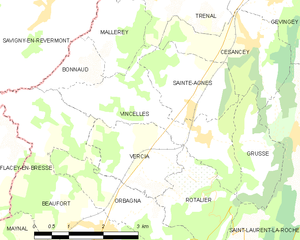
Vincelles
Hiking in Vincelles
Vincelles is a charming village located in the Jura department of France, known for its beautiful natural landscapes and outdoor activities, including hiking. The Jura mountains, with their rolling hills, forests, and stunning vistas, offer an array of trails suitable for hikers of all levels. Here are some highlights about hiking in and around Vincelles:...
- Страна:
- Почтовый код: 39190
- Координаты: 46° 36' 1" N, 5° 28' 44" E
- GPS треки (wikiloc): [Ссылка]
- Площадь: 6.29 кв.км
- Население: 374


Grusse
Hiking in Grusse
Grusse seems to be a less commonly referenced location that may not have widely known trails or hiking areas. It’s possible you may be referring to a niche area or an alternate spelling of a location. However, many places around the world offer beautiful hiking opportunities....
- Страна:
- Почтовый код: 39190
- Координаты: 46° 35' 55" N, 5° 30' 4" E
- GPS треки (wikiloc): [Ссылка]
- Площадь: 3.25 кв.км
- Население: 188


Mallerey
Hiking in Mallerey
Mallerey is not a well-known hiking destination, and it appears that there might be a typographical error in the name. If you meant a specific location, please clarify. However, if you're looking for hiking experiences in general, I can provide you with some tips and recommendations for popular hiking areas or destinations....
- Страна:
- Почтовый код: 39190
- Координаты: 46° 37' 53" N, 5° 26' 53" E
- GPS треки (wikiloc): [Ссылка]
- Площадь: 2.9 кв.км
- Население: 70


Maynal
- коммуна во Франции
Hiking in Maynal
It seems you might be referring to a specific location called "Maynal." However, I don't have specific information on a hiking area or trail by that name. If you're looking for information on hiking in a particular region or park, please provide a bit more context, such as the country or nearby landmarks, and I can offer general advice on hiking in similar areas....
- Страна:
- Почтовый код: 39190
- Координаты: 46° 33' 35" N, 5° 25' 19" E
- GPS треки (wikiloc): [Ссылка]
- Площадь: 8.14 кв.км
- Население: 346


Orbagna
- коммуна во Франции
Hiking in Orbagna
Orbagna is a lesser-known hiking destination, often praised for its natural beauty and serene landscapes. While specific trails might vary in difficulty and length, you can typically expect a mix of terrain, including forest paths, rocky routes, and gentle slopes. Here are some general tips and information for hiking in Orbagna:...
- Страна:
- Почтовый код: 39190
- Координаты: 46° 34' 53" N, 5° 27' 4" E
- GPS треки (wikiloc): [Ссылка]
- Площадь: 4.11 кв.км
- Население: 217


Bonnaud
- коммуна во Франции
Hiking in Bonnaud
Bonnaud is a lesser-known hiking destination, and it’s important to specify whether you mean a specific area, park, or region associated with that name, as it’s not widely recognized like other hiking spots. However, if you are referring to a local area or a specific trail system, I can certainly provide some general tips and considerations for hiking in that region or similar areas....
- Страна:
- Почтовый код: 39190
- Координаты: 46° 37' 5" N, 5° 25' 38" E
- GPS треки (wikiloc): [Ссылка]
- Площадь: 1.65 кв.км
- Население: 50


Rosay
Hiking in Rosay
Hiking in Rosay, located in the Jura region of France, offers stunning landscapes, diverse trails, and a rich natural environment. The Jura mountains are known for their rolling hills, dense forests, and picturesque vistas, providing an excellent backdrop for outdoor enthusiasts....
- Страна:
- Почтовый код: 39190
- Координаты: 46° 31' 53" N, 5° 27' 5" E
- GPS треки (wikiloc): [Ссылка]
- Площадь: 9.93 кв.км
- Население: 125


Rotalier
- коммуна во Франции
Hiking in Rotalier
It seems there might be a typo or misunderstanding regarding the location "Rotalier," as it does not correspond to any well-known hiking destination. However, if you meant "Rottaler," which is part of the Bavarian Forest in Germany, or you might be referring to a specific region or area with a variation on the name....
- Страна:
- Почтовый код: 39190
- Координаты: 46° 35' 20" N, 5° 28' 37" E
- GPS треки (wikiloc): [Ссылка]
- Площадь: 4.07 кв.км
- Население: 172


Saint-Laurent-la-Roche
- коммуна во Франции
Hiking in Saint-Laurent-la-Roche
Saint-Laurent-la-Roche is a charming commune located in the French Alps, known for its picturesque landscapes and natural beauty, making it a great destination for hiking enthusiasts. The area offers a variety of trails that cater to different skill levels, from easy walks suitable for families to more challenging hikes for experienced trekkers....
- Страна:
- Почтовый код: 39570
- Координаты: 46° 36' 1" N, 5° 30' 57" E
- GPS треки (wikiloc): [Ссылка]
- Площадь: 11.13 кв.км
- Население: 334


Cousance
- коммуна во Франции
Hiking in Cousance
Cousance is a charming area located in the Jura department of eastern France, known for its natural beauty and picturesque landscapes. While it may not be as widely recognized as some other hiking destinations, it offers a range of scenic trails and outdoor activities suitable for hikers of all skill levels....
- Страна:
- Почтовый код: 39190
- Координаты: 46° 31' 55" N, 5° 23' 26" E
- GPS треки (wikiloc): [Ссылка]
- Высота над уровнем моря: 240 м m
- Площадь: 6.39 кв.км
- Население: 1295
- Веб сайт: [Ссылка]


Vercia
- коммуна во Франции
Hiking in Vercia
It seems there might be a typo in your request, as "Vercia" isn't a widely recognized hiking destination or region. If you meant "Vercors," which is a mountain range located in the French Pre-Alps, I can provide information on hiking in that area....
- Страна:
- Почтовый код: 39190
- Координаты: 46° 35' 26" N, 5° 27' 24" E
- GPS треки (wikiloc): [Ссылка]
- Площадь: 4.06 кв.км
- Население: 306


Augea
- коммуна во Франции
Hiking in Augea
While I don't have specific information about a location named "Augea," it’s possible you're referring to a region or national park that may not be widely recognized or is known under a different name. It's also possible that it’s a local or lesser-known hiking destination....
- Страна:
- Почтовый код: 39190
- Координаты: 46° 33' 16" N, 5° 24' 42" E
- GPS треки (wikiloc): [Ссылка]
- Площадь: 7.52 кв.км
- Население: 288


Sainte-Agnès
Hiking in Sainte-Agnès
Sainte-Agnès, situated in the Jura region of France, offers a beautiful setting for hiking enthusiasts, featuring stunning landscapes, lush forests, and picturesque views of the mountains. Here are some essential aspects to consider when hiking in this area:...
- Страна:
- Почтовый код: 39190
- Координаты: 46° 36' 29" N, 5° 28' 24" E
- GPS треки (wikiloc): [Ссылка]
- Площадь: 4.08 кв.км
- Население: 355