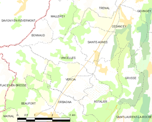
Rotalier (Rotalier)

- коммуна во Франции
 Hiking in Rotalier
It seems there might be a typo or misunderstanding regarding the location "Rotalier," as it does not correspond to any well-known hiking destination. However, if you meant "Rottaler," which is part of the Bavarian Forest in Germany, or you might be referring to a specific region or area with a variation on the name.
Assuming you’re interested in hiking in a general region or perhaps you have a specific area in mind, here’s how you can approach hiking in mountainous or forested areas:
-
Trail Selection: Research local trails that match your fitness level and experience. Popular regions often have websites or guidebooks detailing trail difficulty and length.
-
Safety Precautions: Always inform someone about your hiking plans, carry a map or GPS device, and be aware of the weather conditions. Proper gear, including sturdy shoes and weather-appropriate clothing, is essential.
-
Wildlife Awareness: If hiking in areas with wildlife, know about the animals in the region and how to behave safely around them.
-
Leave No Trace: Practice the Leave No Trace principles. Respect nature by staying on marked trails, packing out your trash, and minimizing campfire impact if you're staying overnight.
-
Group Hiking: If you're a beginner, consider hiking with a group or guided tour to learn from more experienced hikers.
If you provide more context or clarify the location you're interested in, I would be happy to give more specific advice!
- Страна:

- Почтовый код: 39190
- Координаты: 46° 35' 20" N, 5° 28' 37" E


- GPS треки (wikiloc): [Ссылка]
- Площадь: 4.07 кв.км
- Население: 172
- Википедия английская: wiki(en)
- Википедия национальная: wiki(fr)
- Хранилище Wikidata: Wikidata: Q614513
- Катеория в википедии: [Ссылка]
- код Freebase: [/m/03nth7n]
- код GeoNames: Альт: [6433728]
- номер SIREN: [213904675]
- код BNF: [152588293]
- код муниципалитета INSEE: 39467
Граничит с регионами:


Augisey
- коммуна во Франции
Hiking in Augisey
It seems there might be a typographical error in "Augisey," as it doesn't correspond to a well-known hiking destination. However, if you meant "Augisey," it’s possible you’re referring to a location that may not be widely recognized or perhaps it is a lesser-known trail or region....
- Страна:
- Почтовый код: 39270
- Координаты: 46° 33' 11" N, 5° 29' 33" E
- GPS треки (wikiloc): [Ссылка]
- Площадь: 9.29 кв.км
- Население: 217

Vincelles
Hiking in Vincelles
Vincelles is a charming village located in the Jura department of France, known for its beautiful natural landscapes and outdoor activities, including hiking. The Jura mountains, with their rolling hills, forests, and stunning vistas, offer an array of trails suitable for hikers of all levels. Here are some highlights about hiking in and around Vincelles:...
- Страна:
- Почтовый код: 39190
- Координаты: 46° 36' 1" N, 5° 28' 44" E
- GPS треки (wikiloc): [Ссылка]
- Площадь: 6.29 кв.км
- Население: 374


Grusse
Hiking in Grusse
Grusse seems to be a less commonly referenced location that may not have widely known trails or hiking areas. It’s possible you may be referring to a niche area or an alternate spelling of a location. However, many places around the world offer beautiful hiking opportunities....
- Страна:
- Почтовый код: 39190
- Координаты: 46° 35' 55" N, 5° 30' 4" E
- GPS треки (wikiloc): [Ссылка]
- Площадь: 3.25 кв.км
- Население: 188


Orbagna
- коммуна во Франции
Hiking in Orbagna
Orbagna is a lesser-known hiking destination, often praised for its natural beauty and serene landscapes. While specific trails might vary in difficulty and length, you can typically expect a mix of terrain, including forest paths, rocky routes, and gentle slopes. Here are some general tips and information for hiking in Orbagna:...
- Страна:
- Почтовый код: 39190
- Координаты: 46° 34' 53" N, 5° 27' 4" E
- GPS треки (wikiloc): [Ссылка]
- Площадь: 4.11 кв.км
- Население: 217


Rosay
Hiking in Rosay
Hiking in Rosay, located in the Jura region of France, offers stunning landscapes, diverse trails, and a rich natural environment. The Jura mountains are known for their rolling hills, dense forests, and picturesque vistas, providing an excellent backdrop for outdoor enthusiasts....
- Страна:
- Почтовый код: 39190
- Координаты: 46° 31' 53" N, 5° 27' 5" E
- GPS треки (wikiloc): [Ссылка]
- Площадь: 9.93 кв.км
- Население: 125


Saint-Laurent-la-Roche
- коммуна во Франции
Hiking in Saint-Laurent-la-Roche
Saint-Laurent-la-Roche is a charming commune located in the French Alps, known for its picturesque landscapes and natural beauty, making it a great destination for hiking enthusiasts. The area offers a variety of trails that cater to different skill levels, from easy walks suitable for families to more challenging hikes for experienced trekkers....
- Страна:
- Почтовый код: 39570
- Координаты: 46° 36' 1" N, 5° 30' 57" E
- GPS треки (wikiloc): [Ссылка]
- Площадь: 11.13 кв.км
- Население: 334


Vercia
- коммуна во Франции
Hiking in Vercia
It seems there might be a typo in your request, as "Vercia" isn't a widely recognized hiking destination or region. If you meant "Vercors," which is a mountain range located in the French Pre-Alps, I can provide information on hiking in that area....
- Страна:
- Почтовый код: 39190
- Координаты: 46° 35' 26" N, 5° 27' 24" E
- GPS треки (wikiloc): [Ссылка]
- Площадь: 4.06 кв.км
- Население: 306