canton of Lons-le-Saunier-Sud (canton de Lons-le-Saunier-Sud)
 Hiking in canton of Lons-le-Saunier-Sud
Canton de Lons-le-Saunier-Sud is located in the Jura department in the region of Bourgogne-Franche-Comté in eastern France. This area is characterized by its rolling hills, lush forests, and beautiful landscapes, making it a great destination for hiking enthusiasts.
Key Features for Hiking in Canton de Lons-le-Saunier-Sud:
-
Diverse Trails: There are numerous trails available for hikers of all levels, ranging from easy walks suitable for families to more challenging routes for experienced hikers.
-
Natural Beauty: The region is known for its stunning scenery, including woodlands, meadows, and panoramic views of the Jura Mountains. Spring and summer offer vibrant flora, while fall brings beautiful autumn colors.
-
Rich Flora and Fauna: Hikers can expect to encounter diverse wildlife and plants, including endemic species that thrive in the Jura region. Birdwatching and observing local wildlife can enhance your hiking experience.
-
Cultural Heritage: Along the hiking trails, you may find historical sites, charming villages, and traditional architecture that reflect the local culture and history. Stopping at local farms or markets can provide a taste of regional specialties.
-
Accessibility: Many trails are well-marked and accessible, making it easier for hikers to navigate. The area is also relatively peaceful compared to more commercialized hiking regions, providing a tranquil experience in nature.
-
Local Amenities: Towns like Lons-le-Saunier offer facilities such as visitor centers, restaurants, and accommodations, making it convenient for hikers to plan their trips and enjoy local cuisine after a day on the trails.
Suggested Hiking Routes:
- Le Sentier des Moines: A scenic trail that can take you through tranquil woodlands and offers beautiful views over the surrounding valleys.
- Les Gorges de l'Ain: A more adventurous route that follows the Ain River, showcasing stunning gorges and unique geological formations.
- Les Crêtes du Jura: A challenging hike that rewards you with breathtaking views from the ridges of the Jura Mountains.
Tips for Hiking in the Region:
- Weather Check: The weather can be unpredictable, so it’s advisable to check forecasts and be prepared for changes.
- Essential Gear: Good hiking boots, water, snacks, and a map or GPS device are essential for a safe hiking experience.
- Leave No Trace: Be respectful of nature by following the Leave No Trace principles to preserve the area’s beauty.
Overall, hiking in Canton de Lons-le-Saunier-Sud offers an enriching experience amidst stunning landscapes, fresh air, and the chance to engage with the local culture. Happy hiking!
- Страна:

- Столица: Лонс-ле-Сонье
- Координаты: 46° 38' 41" N, 5° 31' 37" E


- GPS треки (wikiloc): [Ссылка]
- Хранилище Wikidata: Wikidata: Q1725970
- код кантона INSEE: [3934]
Включает регионы:


Chilly-le-Vignoble
- коммуна во Франции
Hiking in Chilly-le-Vignoble
Chilly-le-Vignoble is a charming commune located in the Jura department of France, known for its picturesque landscapes, lush forests, and rich cultural heritage. While it's less renowned than some other hiking destinations in the country, it offers opportunities for those looking to explore nature off the beaten path....
- Страна:
- Почтовый код: 39570
- Координаты: 46° 39' 28" N, 5° 30' 0" E
- GPS треки (wikiloc): [Ссылка]
- Площадь: 3.07 кв.км
- Население: 668


Trenal
- коммуна во Франции
Hiking in Trenal
Trenal does not seem to be a widely recognized or prominent hiking destination based on the information available up to October 2023. It’s possible that it may refer to a lesser-known area or a smaller locality....
- Страна:
- Почтовый код: 39570
- Координаты: 46° 38' 36" N, 5° 28' 3" E
- GPS треки (wikiloc): [Ссылка]
- Площадь: 6.64 кв.км
- Население: 383


Moiron
- коммуна Франции
Hiking in Moiron
It seems like there might be a slight misunderstanding, as there isn't a well-known hiking destination specifically called "Moiron." However, if you're referring to hiking in a region or area with a similar name, there may be multiple options globally....
- Страна:
- Почтовый код: 39570
- Координаты: 46° 38' 17" N, 5° 33' 44" E
- GPS треки (wikiloc): [Ссылка]
- Площадь: 1.85 кв.км
- Население: 133


Gevingey
- коммуна во Франции
Hiking in Gevingey
Gevingey is a charming village located in the Jura department of France, surrounded by beautiful natural landscapes, making it a great destination for hiking enthusiasts. The region is characterized by rolling hills, lush forests, and picturesque vineyards, offering a variety of trails for different skill levels....
- Страна:
- Почтовый код: 39570
- Координаты: 46° 38' 12" N, 5° 30' 22" E
- GPS треки (wikiloc): [Ссылка]
- Площадь: 5.9 кв.км
- Население: 455


Geruge
- коммуна во Франции
Hiking in Geruge
It seems there may be a typo in your query, as "Geruge" doesn't correspond to any well-known hiking destination that I'm aware of. If you intended to ask about "Gorge," "Gurage" (a region in Ethiopia), or a specific area with a similar name, please clarify, and I’d be happy to provide information....
- Страна:
- Почтовый код: 39570
- Координаты: 46° 37' 37" N, 5° 31' 45" E
- GPS треки (wikiloc): [Ссылка]
- Площадь: 4.36 кв.км
- Население: 168


Macornay
- коммуна во Франции
Hiking in Macornay
It seems there might be a typographical error or confusion regarding the location name "Macornay," as it doesn't appear to be a well-known hiking destination. If you meant to inquire about a specific region, park, or country (for example, "Macaronesia" or a particular area in France like "Macorny"), please clarify....
- Страна:
- Почтовый код: 39570
- Координаты: 46° 38' 41" N, 5° 32' 29" E
- GPS треки (wikiloc): [Ссылка]
- Площадь: 4.6 кв.км
- Население: 990
- Веб сайт: [Ссылка]


Messia-sur-Sorne
- коммуна во Франции
Hiking in Messia-sur-Sorne
Messia-sur-Sorne is a charming little village located in the Jura department of France, known for its picturesque landscapes and outdoor activities, including hiking. The region features rolling hills, lush forests, and scenic valleys, making it an excellent destination for nature enthusiasts and hikers....
- Страна:
- Почтовый код: 39570
- Координаты: 46° 39' 44" N, 5° 30' 44" E
- GPS треки (wikiloc): [Ссылка]
- Площадь: 2.69 кв.км
- Население: 843
- Веб сайт: [Ссылка]


Vernantois
- коммуна во Франции
Hiking in Vernantois
Vernantois is a small commune located in the Jura department of eastern France. It's known for its picturesque landscapes, rolling hills, and proximity to the Jura mountain range, making it an appealing destination for hikers and outdoor enthusiasts....
- Страна:
- Почтовый код: 39570
- Координаты: 46° 37' 43" N, 5° 34' 35" E
- GPS треки (wikiloc): [Ссылка]
- Площадь: 6.99 кв.км
- Население: 343

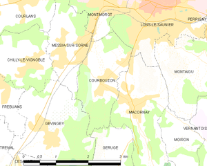
Courbouzon
- коммуна во Франции
Hiking in Courbouzon
Courbouzon is a picturesque village located in the Jura region of France, known for its stunning natural landscapes and outdoor activities, including hiking. Here are some key points to consider when hiking in and around Courbouzon:...
- Страна:
- Почтовый код: 39570
- Координаты: 46° 39' 4" N, 5° 31' 42" E
- GPS треки (wikiloc): [Ссылка]
- Площадь: 3.35 кв.км
- Население: 585


Bornay
- коммуна во Франции
Hiking in Bornay
Bornay is a picturesque area located in the Jura Mountains of France, known for its stunning landscapes, dense forests, and peaceful valleys. While it might not be as famous as some larger hiking destinations, it offers a wealth of natural beauty and opportunities for outdoor activities....
- Страна:
- Почтовый код: 39570
- Координаты: 46° 36' 52" N, 5° 33' 18" E
- GPS треки (wikiloc): [Ссылка]
- Площадь: 6.76 кв.км
- Население: 171


Frébuans
- коммуна во Франции
Hiking in Frébuans
Frébuans is a picturesque area located in the Jura region of France, known for its lush landscapes, charming villages, and diverse hiking trails. While specific information about Frébuans might not be extensive, I can provide you with an overview of what you might expect when hiking in such a region....
- Страна:
- Почтовый код: 39570
- Координаты: 46° 39' 9" N, 5° 29' 12" E
- GPS треки (wikiloc): [Ссылка]
- Площадь: 2.65 кв.км
- Население: 382
- Веб сайт: [Ссылка]