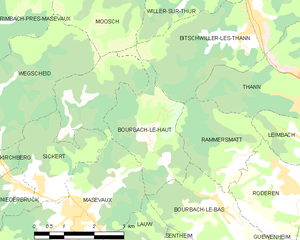
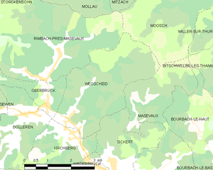
Мазво (canton of Masevaux, canton de Masevaux)

 Hiking in Мазво
The Canton of Masevaux, located in the Haut-Rhin department in the Alsace region of France, offers a wonderful variety of hiking opportunities. Nestled at the foothills of the Vosges Mountains, this area is known for its picturesque landscapes, charming villages, and rich natural diversity.
Hiking Highlights in the Canton of Masevaux:
-
Scenic Trails: The region features numerous marked hiking trails that range from easy family-friendly walks to more challenging routes for experienced hikers. Notable trails include parts of the GR5 and GR53 long-distance paths.
-
Natural Beauty: Hikers can enjoy lush forests, rolling hills, and beautiful valleys. The nearby Parc naturel régional des Ballons des Vosges offers stunning views, especially from higher altitudes, with opportunities to see a variety of flora and fauna.
-
Historical Sites: The area is rich in history, and many trails pass by ancient ruins, traditional Alsatian houses, and historical sites such as the remnants of fortified churches or castles.
-
Floral and Fauna Exploration: The Canton is home to numerous protected areas and diverse ecosystems, making it an excellent spot for nature enthusiasts and bird watchers.
-
Accessibility: Many trails start from the main villages within the canton, making them easily accessible. The charming towns of Masevaux, Bernwiller, and others provide facilities such as accommodation and restaurants where hikers can rest and replenish.
-
Local Culture: Exploring the local culture can enhance the hiking experience. After a day on the trails, visitors can enjoy Alsatian cuisine in local eateries or participate in cultural events in the villages.
Tips for Hiking in the Canton of Masevaux:
- Trail Maps: It’s advisable to get a good map or trail guide for the area, as many paths may not be well-signed.
- Check Weather Conditions: The weather can change rapidly, especially in mountainous areas, so be prepared with suitable gear.
- Hydration and Snacks: Always carry enough water and snacks, particularly on longer hikes.
- Respect Nature: Stay on marked trails, and be mindful of the local wildlife and vegetation.
Whether you are looking for a leisurely stroll or a more adventurous hike, the Canton of Masevaux has something to offer for everyone. Enjoy your adventure in this beautiful part of France!
- Страна:

- Координаты: 47° 47' 0" N, 7° 0' 0" E


- GPS треки (wikiloc): [Ссылка]
- Площадь: 390.44 кв.км
- Население: 38433
- Википедия русская: wiki(ru)
- Википедия английская: wiki(en)
- Википедия национальная: wiki(fr)
- Хранилище Wikidata: Wikidata: Q1398665
- код LCNAF: Альт: [n2004002143]
- код кантона INSEE: [6809]
Включает регионы:


Киршберг
- коммуна во Франции
- Страна:
- Почтовый код: 68290
- Координаты: 47° 47' 48" N, 6° 57' 7" E
- GPS треки (wikiloc): [Ссылка]
- Площадь: 6.74 кв.км
- Население: 801


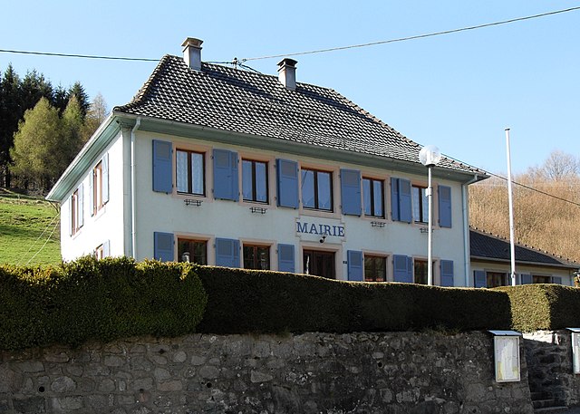
Мазво
- коммуна во Франции
- Страна:
- Почтовый код: 68290
- Координаты: 47° 46' 25" N, 6° 59' 45" E
- GPS треки (wikiloc): [Ссылка]
- Площадь: 23.21 кв.км
- Население: 3361
- Веб сайт: [Ссылка]


Лов
- коммуна во Франции
- Страна:
- Почтовый код: 68290
- Координаты: 47° 45' 21" N, 7° 1' 11" E
- GPS треки (wikiloc): [Ссылка]
- Площадь: 4.61 кв.км
- Население: 919


Обербрюк
- коммуна во Франции
- Страна:
- Почтовый код: 68290
- Координаты: 47° 48' 33" N, 6° 56' 33" E
- GPS треки (wikiloc): [Ссылка]
- Площадь: 4.3 кв.км
- Население: 401

Рембак-пре-Мазво
- коммуна во Франции
- Страна:
- Почтовый код: 68290
- Координаты: 47° 49' 41" N, 6° 57' 4" E
- GPS треки (wikiloc): [Ссылка]
- Площадь: 16.66 кв.км
- Население: 468


Мортсвиллер
- коммуна во Франции
- Страна:
- Почтовый код: 68780
- Координаты: 47° 44' 26" N, 7° 2' 16" E
- GPS треки (wikiloc): [Ссылка]
- Площадь: 4.23 кв.км
- Население: 347


Нидербрюк
- коммуна во Франции
- Страна:
- Почтовый код: 68290
- Координаты: 47° 47' 5" N, 6° 58' 3" E
- GPS треки (wikiloc): [Ссылка]
- Площадь: 3.78 кв.км
- Население: 437

Бурбак-ле-О
- коммуна во Франции
- Страна:
- Почтовый код: 68290
- Координаты: 47° 47' 44" N, 7° 1' 47" E
- GPS треки (wikiloc): [Ссылка]
- Площадь: 6.86 кв.км
- Население: 417
- Веб сайт: [Ссылка]


Доллерен
- коммуна Франции
- Страна:
- Почтовый код: 68290
- Координаты: 47° 48' 21" N, 6° 55' 55" E
- GPS треки (wikiloc): [Ссылка]
- Площадь: 8.37 кв.км
- Население: 465


Сентайм
- коммуна во Франции
- Страна:
- Почтовый код: 68780
- Координаты: 47° 45' 18" N, 7° 3' 4" E
- GPS треки (wikiloc): [Ссылка]
- Площадь: 6.18 кв.км
- Население: 1595
- Веб сайт: [Ссылка]


Сопп-ле-Ба
- коммуна во Франции
Hiking in Сопп-ле-Ба
Soppe-le-Bas is a small commune located in the Haute-Saône department in the Bourgogne-Franche-Comté region of eastern France. While it may not be one of the most famous hiking destinations in France, it offers opportunities for outdoor enthusiasts to explore the beautiful rural landscapes of the region....
- Страна:
- Почтовый код: 68780
- Координаты: 47° 43' 2" N, 7° 5' 22" E
- GPS треки (wikiloc): [Ссылка]
- Площадь: 5.68 кв.км
- Население: 770


Севен
- коммуна во Франции
- Страна:
- Почтовый код: 68290
- Координаты: 47° 48' 27" N, 6° 54' 19" E
- GPS треки (wikiloc): [Ссылка]
- Площадь: 21.5 кв.км
- Население: 506


Сопп-ле-О
- коммуна во Франции
- Страна:
- Почтовый код: 68780
- Координаты: 47° 43' 55" N, 7° 3' 39" E
- GPS треки (wikiloc): [Ссылка]
- Площадь: 7.37 кв.км
- Население: 569

Вегшайд
- коммуна во Франции
- Страна:
- Почтовый код: 68290
- Координаты: 47° 47' 58" N, 6° 57' 29" E
- GPS треки (wikiloc): [Ссылка]
- Площадь: 10.06 кв.км
- Население: 327


Сиккерт
- коммуна во Франции
- Страна:
- Почтовый код: 68290
- Координаты: 47° 47' 2" N, 6° 58' 44" E
- GPS треки (wikiloc): [Ссылка]
- Площадь: 5.12 кв.км
- Население: 324