Нантюа (canton of Nantua, canton de Nantua)

- кантон Франции
 Hiking in Нантюа
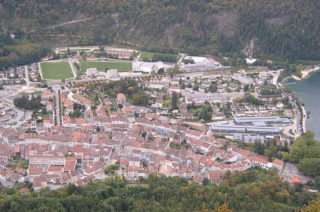
The Canton of Nantua, located in the Ain department in the Auvergne-Rhône-Alpes region of France, is a beautiful destination for hiking enthusiasts. The area is characterized by its stunning landscapes, including mountains, lakes, and forests, offering a diverse range of hiking opportunities for all skill levels.
Key Features of Hiking in the Canton of Nantua:
-
Scenic Trails: The region boasts a variety of well-marked trails that traverse through picturesque settings. You can find paths that lead through lush forests, alongside the stunning Nantua Lake, and up to panoramic viewpoints, such as the Belvédère de la Dent du Chat.
-
Lake Nantua: The lake itself is a highlight for hikers. It offers opportunities for water-related activities as well, and you can enjoy scenic trails that circle the lake, providing lovely views and picnic spots along the way.
-
Diversity of Terrain: Trails vary from easy lakeside strolls to moderate and challenging mountain hikes. This makes the Canton of Nantua suitable for both casual walkers and more experienced hikers seeking a challenge.
-
Wildlife and Nature: The area is rich in biodiversity, with various fauna and flora. As you hike, you may encounter unique wildlife, enjoy birdwatching, and appreciate the native plant species.
-
Cultural Heritage: Hiking in this region also offers a glimpse of local culture. You might come across charming villages, historical sites, and opportunities to taste regional cuisine at local eateries.
-
Accessibility: The Canton is relatively accessible from major cities such as Geneva and Lyon, making it a feasible destination for day hikes or weekend getaways.
-
Seasonal Variations: The hiking experience can vary greatly by season. Summer hikes can be warm and lush, while autumn brings breathtaking fall foliage. In winter, some trails might be suitable for snowshoeing or winter hiking, depending on conditions.
Tips for Hiking in the Canton of Nantua:
- Check Trail Conditions: Before setting out, check local resources or visitor centers for trail conditions and any advisories.
- Stay Hydrated: Bring sufficient water, especially during warmer months.
- Dress Appropriately: Weather can change quickly in mountainous areas, so dress in layers and pack appropriate gear.
- Leave No Trace: Respect the natural environment by sticking to marked trails and carrying out any waste.
- Explore Local Guides: Consider joining a guided hike to learn more about the local flora, fauna, and history.
Hiking in the Canton of Nantua offers an excellent mix of natural beauty, adventure, and cultural experiences. Whether you're an experienced hiker or a beginner, you're sure to find trails that suit your preferences in this magnificent region of France.
- Страна:

- Столица: Нантюа
- Координаты: 46° 9' 7" N, 5° 36' 28" E


- GPS треки (wikiloc): [Ссылка]
- Площадь: 144.98 кв.км
- Население: 21459
- Википедия русская: wiki(ru)
- Википедия английская: wiki(en)
- Википедия национальная: wiki(fr)
- Хранилище Wikidata: Wikidata: Q1726470
- код Freebase: [/m/0409j6f]
- код кантона INSEE: [0114]
Включает регионы:
Нантюа
- коммуна во Франции
Hiking in Нантюа
Nantua, located in the Ain department of the Auvergne-Rhône-Alpes region in southeastern France, is a beautiful spot for hiking enthusiasts. Nestled near the Jura Mountains and surrounding a picturesque lake, Nantua offers a variety of scenic trails with stunning views of nature, local wildlife, and breathtaking landscapes....
- Страна:
- Почтовый код: 01460
- Координаты: 46° 9' 12" N, 5° 36' 22" E
- GPS треки (wikiloc): [Ссылка]
- Площадь: 12.79 кв.км
- Население: 3525
- Веб сайт: [Ссылка]


Апремон
- коммуна в департаменте Эн, Франция
Hiking in Апремон
Apremont, located in the Ain department of France, is a lovely area that offers a variety of hiking opportunities in a beautiful natural setting. The region is characterized by its picturesque landscapes, lush forests, and charming villages. Here are some points to consider if you're planning to hike in Apremont:...
- Страна:
- Почтовый код: 01100
- Координаты: 46° 12' 25" N, 5° 39' 24" E
- GPS треки (wikiloc): [Ссылка]
- Площадь: 14.57 кв.км
- Население: 390
- Веб сайт: [Ссылка]

Le Poizat-Lalleyriat
Hiking in Le Poizat-Lalleyriat
Le Poizat-Lalleyriat is a picturesque village located in the Ain department of the Auvergne-Rhône-Alpes region in France. It's nestled in the Jura Mountains, making it a fantastic destination for hiking enthusiasts. Here are some highlights and tips for hiking in this area:...
- Страна:
- Почтовый код: 01130
- Координаты: 46° 8' 42" N, 5° 41' 46" E
- GPS треки (wikiloc): [Ссылка]
- Площадь: 33.15 кв.км
- Веб сайт: [Ссылка]

Брион
- коммуна во Франции, департамент Эн
Hiking in Брион
Brion, located in the Ain department in the Auvergne-Rhône-Alpes region of France, offers a picturesque setting for hiking enthusiasts. The region is characterized by its beautiful natural landscapes, rolling hills, oak forests, and charming rural scenery. Here are some key points to consider when hiking in Brion:...
- Страна:
- Почтовый код: 01460
- Координаты: 46° 10' 22" N, 5° 33' 9" E
- GPS треки (wikiloc): [Ссылка]
- Площадь: 4.48 кв.км
- Население: 515