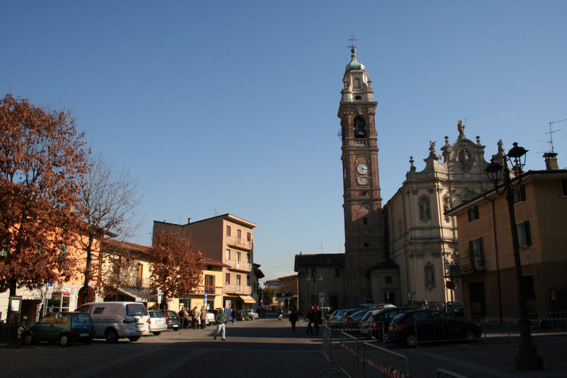
Филаго (Filago, Filago)
.svg)
- коммуна Италии
 Hiking in Филаго
Filago, located in the Lombardy region of Italy, offers a serene experience for hikers looking to explore the picturesque landscapes of Northern Italy. While it may not be as widely known as some other hiking destinations, it is surrounded by beautiful natural areas and charming villages that enhance the hiking experience.
Hiking Opportunities
-
Local Trails: The region around Filago has several trails that vary in difficulty, suitable for both beginners and experienced hikers. Check local maps or guides for specific routes.
-
Parco Regionale della Valle del Lambro: A short distance from Filago, this regional park offers extensive trails through woodlands and along riverbanks, providing excellent hiking opportunities with varied terrain and beautiful views.
-
Cultural Walks: If you enjoy combining nature and culture, consider exploring the area’s historical paths that connect Filago to nearby towns and points of interest.
Tips for Hiking in Filago
- Weather: The weather in Lombardy can vary; it’s important to check forecasts and be prepared for unexpected changes.
- Gear: Wear appropriate hiking shoes and bring along essentials such as water, snacks, a first-aid kit, and perhaps walking poles for stability, especially on uneven terrain.
- Local Guidelines: Respect local guidelines and trail markers, and be sure to follow Leave No Trace principles to preserve the natural beauty of the area.
Accessibility
Filago is well-connected to larger cities like Bergamo and Milan, making it easy to reach for a day hike. Public transportation options are usually available, including trains and buses.
Whether you’re looking for a peaceful nature walk or a more challenging hike, Filago and its surrounding areas offer a lovely escape into the natural beauty of Lombardy. Always check local resources or guides for the latest trail information and conditions before heading out. Enjoy your hike!
- Страна:

- Почтовый код: 24040
- Телефонный код: 035
- Код автомобильного номера: BG
- Координаты: 45° 38' 0" N, 9° 33' 0" E


- GPS треки (wikiloc): [Ссылка]
- Высота над уровнем моря: 190 м m
- Площадь: 5.42 кв.км
- Население: 3182
- Веб сайт: http://www.comune.filago.bg.it
- Википедия русская: wiki(ru)
- Википедия английская: wiki(en)
- Википедия национальная: wiki(it)
- Хранилище Wikidata: Wikidata: Q101048
- Катеория в википедии: [Ссылка]
- код Freebase: [/m/0gjb3_]
- код GeoNames: Альт: [6542950]
- код VIAF: Альт: [246966464]
- ID отношения в OpenStreetMap: [45551]
- UN/LOCODE: [ITFIL]
- код ISTAT: 016098
- кадастровый код Италии: D588
Граничит с регионами:


Каприате-Сан-Джервазио
- коммуна Италии
Hiking in Каприате-Сан-Джервазио
Capriate San Gervasio, located in the Lombardy region of northern Italy, offers a variety of outdoor activities, including hiking. This area is not as well-known for hiking compared to other regions in Italy, but it can still provide pleasant nature walks and scenic routes for those looking to explore the local landscape....
- Страна:
- Почтовый код: 24042
- Телефонный код: 02
- Код автомобильного номера: BG
- Координаты: 45° 36' 32" N, 9° 31' 41" E
- GPS треки (wikiloc): [Ссылка]
- Высота над уровнем моря: 188 м m
- Площадь: 5.83 кв.км
- Население: 8173
- Веб сайт: [Ссылка]


Дальмине
- коммуна Италии
Hiking in Дальмине
Dalmine, located in the Lombardy region of Italy, is primarily an urban area, but it offers access to several nearby natural attractions and hiking opportunities. While Dalmine itself may not have extensive trails directly within the city, there are several options in the surrounding regions....
- Страна:
- Почтовый код: 24044
- Телефонный код: 035
- Код автомобильного номера: BG
- Координаты: 45° 39' 0" N, 9° 36' 0" E
- GPS треки (wikiloc): [Ссылка]
- Высота над уровнем моря: 201 м m
- Площадь: 11.81 кв.км
- Население: 23495
- Веб сайт: [Ссылка]


Мадоне
- коммуна Италии
Hiking in Мадоне
Hiking in the Madone area can be a wonderful experience, as it's located in a picturesque region often associated with stunning natural landscapes and diverse hiking trails. While "Madone" could refer to various places, the most prominent reference might be to the Madone di Campiglio in the Italian Alps, known for its breathtaking views, accessible trails, and beautiful alpine scenery....
- Страна:
- Почтовый код: 24040
- Телефонный код: 035
- Код автомобильного номера: BG
- Координаты: 45° 39' 0" N, 9° 33' 0" E
- GPS треки (wikiloc): [Ссылка]
- Высота над уровнем моря: 202 м m
- Площадь: 3.07 кв.км
- Население: 4068
- Веб сайт: [Ссылка]


Озио-Сопра
- коммуна Италии
Hiking in Озио-Сопра
Osio Sopra is a small town in the Lombardy region of Italy, located near Bergamo. While Osio Sopra is primarily an urban area, there are opportunities for hiking and outdoor activities in the surrounding regions. Here are some insights for hiking enthusiasts:...
- Страна:
- Почтовый код: 24040
- Телефонный код: 035
- Код автомобильного номера: BG
- Координаты: 45° 38' 0" N, 9° 35' 0" E
- GPS треки (wikiloc): [Ссылка]
- Высота над уровнем моря: 192 м m
- Площадь: 5.18 кв.км
- Население: 5273
- Веб сайт: [Ссылка]

Озио-Сотто
- коммуна Италии
Hiking in Озио-Сотто
Osio Sotto, located in the Lombardy region of Italy, is not primarily known as a hiking destination, but it does offer some opportunities for outdoor activities and exploration. Its proximity to the larger city of Bergamo and the magnificent landscapes of the nearby Pre-Alps and the Orobie Alps means that there are many hiking trails available not too far from Osio Sotto....
- Страна:
- Почтовый код: 24046
- Телефонный код: 035
- Код автомобильного номера: BG
- Координаты: 45° 37' 0" N, 9° 36' 0" E
- GPS треки (wikiloc): [Ссылка]
- Высота над уровнем моря: 182 м m
- Площадь: 7.59 кв.км
- Население: 12474
- Веб сайт: [Ссылка]

Бонате-Сотто
- коммуна Италии
Hiking in Бонате-Сотто
Bonate Sotto is a charming town located in the Lombardy region of Italy, situated just a few kilometers northeast of Bergamo. While it may not be as well-known as some other hiking destinations, it offers some beautiful landscapes and trails that can be enjoyed by outdoor enthusiasts....
- Страна:
- Почтовый код: 24040
- Телефонный код: 035
- Код автомобильного номера: BG
- Координаты: 45° 40' 0" N, 9° 33' 41" E
- GPS треки (wikiloc): [Ссылка]
- Высота над уровнем моря: 215 м m
- Площадь: 6.47 кв.км
- Население: 6704
- Веб сайт: [Ссылка]


Боттануко
- коммуна Италии
Hiking in Боттануко
Bottanuco is a small town in the province of Bergamo, Lombardy, Italy, which serves as a gateway to the beautiful landscapes of the surrounding region. Hiking around Bottanuco offers a blend of scenic views, cultural experiences, and varying difficulty levels. Here are some key points to consider about hiking in Bottanuco:...
- Страна:
- Почтовый код: 24040
- Телефонный код: 035
- Код автомобильного номера: BG
- Координаты: 45° 38' 23" N, 9° 30' 23" E
- GPS треки (wikiloc): [Ссылка]
- Высота над уровнем моря: 222 м m
- Площадь: 5.77 кв.км
- Население: 5137
- Веб сайт: [Ссылка]


Брембате
- коммуна Италии
Hiking in Брембате
Brembate, located in the province of Bergamo, Italy, is surrounded by beautiful landscapes that offer a variety of hiking opportunities. The area combines natural beauty with historical sites, making it a great destination for both casual hikers and more serious outdoor enthusiasts....
- Страна:
- Почтовый код: 24041
- Телефонный код: 035
- Код автомобильного номера: BG
- Координаты: 45° 36' 0" N, 9° 33' 0" E
- GPS треки (wikiloc): [Ссылка]
- Высота над уровнем моря: 173 м m
- Площадь: 5.54 кв.км
- Население: 8551
- Веб сайт: [Ссылка]