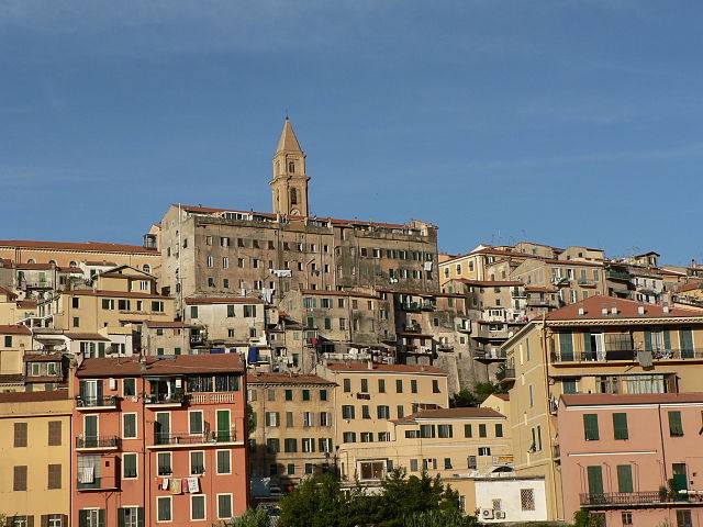
Кастеллар (Castellar, Castellar)

- коммуна в департаменте Приморские Альпы, регион Прованс — Альпы — Лазурный Берег, Франция
 Hiking in Кастеллар
Castellar, located in the Alpes-Maritimes department of France, is a charming village that offers a variety of hiking opportunities. Nestled in the foothills of the Alps, it provides stunning views of the surrounding landscape, including both mountainous terrain and the Mediterranean Sea in the distance.
Hiking Trails
There are several hiking trails in and around Castellar that cater to different skill levels:
-
Sentier de la Domene: This is a popular trail that takes you through scenic landscapes and offers panoramic views of the area. The trail is marked and relatively easy, making it suitable for families.
-
Mont Grand: For more experienced hikers, the trail leading up to Mont Grand presents more challenging terrain, including steeper sections and rocky paths. The summit provides breathtaking views over the coastline and surrounding mountains.
-
Historical Trails: There are also hiking routes that explore historical sites, such as old forts or remnants of ancient villages. These trails combine physical activity with the chance to learn about the local culture and history.
Tips for Hiking in Castellar
- Preparation: Make sure to wear appropriate hiking footwear and bring plenty of water. The climate can vary, so check the weather forecast and dress accordingly.
- Navigation: While most trails are well-marked, carrying a map or GPS device is advisable, especially if you plan to explore less-frequented paths.
- Local Guides: Consider hiring a local guide who can provide insight into the region’s biodiversity and history, and ensure you're aware of the best trails based on your experience level.
Best Time to Hike
The best times for hiking in Castellar are spring (April to June) and autumn (September to October), when temperatures are mild and the natural beauty is at its peak. Summer can be hot, especially in lower elevations, while winter may bring snow to the higher trails.
Additional Activities
Castellar and the surrounding region also offer other activities such as mountain biking, rock climbing, and exploring the nearby Mediterranean coastline, making it a versatile destination for outdoor enthusiasts.
Overall, Castellar is an excellent starting point for hiking adventures in the stunning landscapes of the Alpes-Maritimes. Whether you’re a seasoned hiker or a newcomer, the area offers something for everyone!
- Страна:

- Почтовый код: 06500
- Координаты: 43° 48' 13" N, 7° 29' 48" E


- GPS треки (wikiloc): [Ссылка]
- Высота над уровнем моря: 342 м m
- Площадь: 12.24 кв.км
- Население: 1019
- Веб сайт: http://www.castellar.fr/
- Википедия русская: wiki(ru)
- Википедия английская: wiki(en)
- Википедия национальная: wiki(fr)
- Хранилище Wikidata: Wikidata: Q328398
- Галерея изображений в википедии: [Ссылка]
- Катеория в википедии: [Ссылка]
- код Freebase: [/m/03m4_f3]
- код Freebase: [/m/03m4_f3]
- код GeoNames: Альт: [6446689]
- код GeoNames: Альт: [6446689]
- номер SIREN: [210600359]
- номер SIREN: [210600359]
- идентификатор местоположения ArchINFORM: [559]
- идентификатор местоположения ArchINFORM: [559]
- WOEID: [583244]
- WOEID: [583244]
- код муниципалитета INSEE: 06035
- код муниципалитета INSEE: 06035
Граничит с регионами:

Ментона
- коммуна в департаменте Приморские Альпы, регион Прованс — Альпы — Лазурный Берег, Франция
- Страна:
- Почтовый код: 06500
- Код автомобильного номера: 06
- Координаты: 43° 46' 29" N, 7° 29' 59" E
- GPS треки (wikiloc): [Ссылка]
- Высота над уровнем моря: 16 м m
- Площадь: 14.05 кв.км
- Население: 28231
- Веб сайт: [Ссылка]

Вентимилья
- коммуна Италии
Hiking in Вентимилья
Ventimiglia, located in the Italian Riviera near the border with France, is a fantastic destination for hiking enthusiasts. The area is blessed with stunning coastal views, lush Mediterranean vegetation, and a variety of trails suitable for different skill levels. Here are some highlights and tips for hiking in Ventimiglia:...
- Страна:

- Почтовый код: 18039
- Телефонный код: 0184
- Код автомобильного номера: IM
- Координаты: 43° 47' 25" N, 7° 36' 30" E
- GPS треки (wikiloc): [Ссылка]
- Высота над уровнем моря: 9 м m
- Площадь: 53.73 кв.км
- Население: 24065
- Веб сайт: [Ссылка]


Оливетта-Сан-Микеле
- коммуна Италии
Hiking in Оливетта-Сан-Микеле
Olivetta San Michele is a charming village located in the province of Imperia, in the Liguria region of Italy. Nestled in the beautiful Alps of Liguria, it offers stunning landscapes, rich natural beauty, and several hiking opportunities for outdoor enthusiasts....
- Страна:
- Почтовый код: 18030
- Телефонный код: 0184
- Код автомобильного номера: IM
- Координаты: 43° 52' 47" N, 7° 30' 56" E
- GPS треки (wikiloc): [Ссылка]
- Высота над уровнем моря: 292 м m
- Площадь: 13.84 кв.км
- Население: 214
- Веб сайт: [Ссылка]
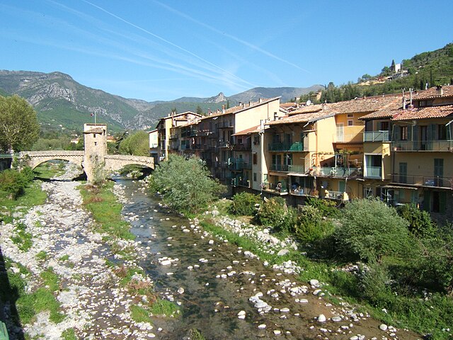

Соспель
- коммуна в департаменте Приморские Альпы, регион Прованс — Альпы — Лазурный Берег, Франция
Hiking in Соспель
Sospel is a charming village located in the Alpes-Maritimes department of France, nestled in the scenic hills near the Italian border. It's an excellent base for hikers, offering a variety of trails that showcase the stunning natural beauty of the region. Here are some highlights of hiking in Sospel:...
- Страна:
- Почтовый код: 06380
- Координаты: 43° 52' 37" N, 7° 26' 54" E
- GPS треки (wikiloc): [Ссылка]
- Высота над уровнем моря: 348 м m
- Площадь: 62.39 кв.км
- Население: 3782
- Веб сайт: [Ссылка]


Кастийон
- коммуна в департаменте Приморские Альпы, регион Прованс — Альпы — Лазурный Берег, Франция
Hiking in Кастийон
Hiking in Castillon, Alpes-Maritimes, offers a unique blend of stunning landscapes, Mediterranean climate, and rich natural biodiversity. Nestled in the foothills of the French Riviera, Castillon is known for its picturesque views, quaint village charm, and a variety of hiking trails suitable for all levels of experience....
- Страна:
- Почтовый код: 06500
- Координаты: 43° 50' 0" N, 7° 28' 20" E
- GPS треки (wikiloc): [Ссылка]
- Площадь: 7.51 кв.км
- Население: 378
- Веб сайт: [Ссылка]