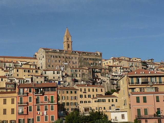
Оливетта-Сан-Микеле (Olivetta San Michele, Olivetta San Michele)
.svg)
- коммуна Италии
 Hiking in Оливетта-Сан-Микеле
Olivetta San Michele is a charming village located in the province of Imperia, in the Liguria region of Italy. Nestled in the beautiful Alps of Liguria, it offers stunning landscapes, rich natural beauty, and several hiking opportunities for outdoor enthusiasts.
Hiking Trails:
-
Liguria Alta: The area around Olivetta San Michele is part of the Alta Via dei Monti Liguri, a long-distance trail that stretches from the French border to the Cinque Terre. This trail offers spectacular views of the Mediterranean and the surrounding mountains.
-
Local Trails: There are various shorter trails and paths that can be explored from the village. These typically lead to neighboring villages, through terraced olive groves, and across scenic landscapes where you can enjoy the local flora and fauna.
-
Monte Grammondo: One highlight for hikers is a trek up to Monte Grammondo, which can be accessed from Olivetta San Michele. The hike offers panoramic views, especially on clear days, and is suitable for intermediate hikers.
Tips for Hiking in Olivetta San Michele:
- Preparation: Wear appropriate hiking gear and bring enough water and snacks. The weather can change rapidly in the mountains, so layering is key.
- Maps and Markers: Make sure to have a good map or use a hiking app for navigation. Trails may not always be well-marked.
- Local Regulations: Respect local wildlife and follow any regulations that are in place to protect the natural environment.
- Timing: Consider the time of year when planning your hike. Spring and autumn can provide ideal conditions for hiking, while summer may be quite hot.
Local Attractions:
After your hike, you can explore the village’s traditional architecture or enjoy local cuisine, which often includes hearty dishes featuring fresh, local ingredients.
Whether you're an experienced hiker or just looking for a leisurely day out in nature, Olivetta San Michele offers a wonderful experience in the Italian countryside. Enjoy your hiking adventure!
- Страна:

- Почтовый код: 18030
- Телефонный код: 0184
- Код автомобильного номера: IM
- Координаты: 43° 52' 47" N, 7° 30' 56" E


- GPS треки (wikiloc): [Ссылка]
- Высота над уровнем моря: 292 м m
- Площадь: 13.84 кв.км
- Население: 214
- Веб сайт: http://www.comune.olivettasanmichele.im.it
- Википедия русская: wiki(ru)
- Википедия английская: wiki(en)
- Википедия национальная: wiki(it)
- Хранилище Wikidata: Wikidata: Q269440
- Катеория в википедии: [Ссылка]
- код Freebase: [/m/0gbyt_]
- код GeoNames: Альт: [3172047]
- ID отношения в OpenStreetMap: [42702]
- код ISTAT: 008038
- кадастровый код Италии: G041
Граничит с регионами:

Вентимилья
- коммуна Италии
Hiking in Вентимилья
Ventimiglia, located in the Italian Riviera near the border with France, is a fantastic destination for hiking enthusiasts. The area is blessed with stunning coastal views, lush Mediterranean vegetation, and a variety of trails suitable for different skill levels. Here are some highlights and tips for hiking in Ventimiglia:...
- Страна:
- Почтовый код: 18039
- Телефонный код: 0184
- Код автомобильного номера: IM
- Координаты: 43° 47' 25" N, 7° 36' 30" E
- GPS треки (wikiloc): [Ссылка]
- Высота над уровнем моря: 9 м m
- Площадь: 53.73 кв.км
- Население: 24065
- Веб сайт: [Ссылка]


Айроле
- коммуна Италии
Hiking in Айроле
Airole is a charming village located in the Liguria region of Italy, near the border with France. It’s nestled in the picturesque valley of the Nervia River, surrounded by stunning landscapes that make it an attractive destination for hikers and nature enthusiasts. Here are some key points to consider when hiking in and around Airole:...
- Страна:
- Почтовый код: 18030
- Телефонный код: 0184
- Код автомобильного номера: IM
- Координаты: 43° 52' 19" N, 7° 33' 12" E
- GPS треки (wikiloc): [Ссылка]
- Высота над уровнем моря: 149 м m
- Площадь: 14.63 кв.км
- Население: 408
- Веб сайт: [Ссылка]


Брей-сюр-Руайя
- коммуна в департаменте Приморские Альпы, регион Прованс — Альпы — Лазурный Берег, Франция
Hiking in Брей-сюр-Руайя
Breil-sur-Roya, located in the Alpes-Maritimes department of France, is a charming village that serves as a gateway to some beautiful hiking trails in the surrounding area. Nestled in the Roya Valley, it offers a mix of stunning natural landscapes, historical sites, and a chance to experience the local culture....
- Страна:

- Почтовый код: 06540
- Координаты: 43° 56' 14" N, 7° 30' 52" E
- GPS треки (wikiloc): [Ссылка]
- Высота над уровнем моря: 287 м m
- Площадь: 81.31 кв.км
- Население: 2271
- Веб сайт: [Ссылка]


Кастеллар
- коммуна в департаменте Приморские Альпы, регион Прованс — Альпы — Лазурный Берег, Франция
Hiking in Кастеллар
Castellar, located in the Alpes-Maritimes department of France, is a charming village that offers a variety of hiking opportunities. Nestled in the foothills of the Alps, it provides stunning views of the surrounding landscape, including both mountainous terrain and the Mediterranean Sea in the distance....
- Страна:
- Почтовый код: 06500
- Координаты: 43° 48' 13" N, 7° 29' 48" E
- GPS треки (wikiloc): [Ссылка]
- Высота над уровнем моря: 342 м m
- Площадь: 12.24 кв.км
- Население: 1019
- Веб сайт: [Ссылка]