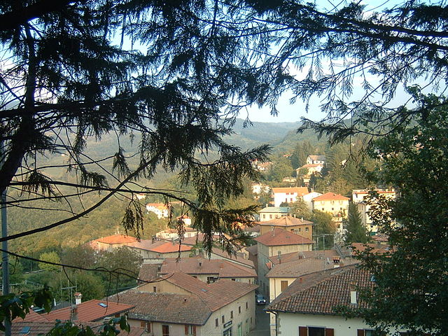
Кастильоне-дей-Пеполи (Castiglione dei Pepoli, Castiglione dei Pepoli)
.svg)
- коммуна Италии
 Hiking in Кастильоне-дей-Пеполи
Castiglione dei Pepoli is a charming village located in the Emilia-Romagna region of Italy, surrounded by the stunning landscapes of the Apennine Mountains. Known for its picturesque scenery, it offers numerous opportunities for hiking enthusiasts to explore the natural beauty of the area.
Hiking Trails
-
The Via degli Dei: One of the most popular trekking routes in this region, the Via degli Dei (Way of the Gods) connects Bologna to Florence and passes through Castiglione dei Pepoli. The trail showcases beautiful views, ancient hermitages, and historic landmarks.
-
Local Nature Trails: There are many shorter trails that cater to various skill levels. These trails can lead you through lush forests, across streams, and up to scenic viewpoints overlooking the Apennine valleys.
-
Parco Regionale dell'Appennino Tosco-Emiliano: This regional park offers a variety of trails suitable for hiking, with diverse flora and fauna and diverse landscapes that range from rolling hills to rugged mountains.
Hiking Tips
-
Best Time to Hike: The ideal times for hiking in this region are during the spring (April to June) and autumn (September to October), when temperatures are mild and the landscapes are particularly beautiful.
-
Equipment: Proper hiking shoes are essential due to the varying terrain. It’s also beneficial to carry a map or GPS device, especially when exploring less marked trails.
-
Safety: Always inform someone about your hiking plans and estimated return time. Carry enough water and snacks, and be aware of weather conditions, as they can change rapidly in mountainous regions.
-
Guided Tours: If you are unfamiliar with the area or prefer a structured experience, consider joining a guided hiking tour that can provide insights into the local culture and environment.
Local Attractions
-
Cultural Sites: After your hikes, you can explore local historical sites such as ancient churches and traditional stone-built houses that reflect the region's history.
-
Cuisine: Don’t miss trying local delicacies in the village, as Emilia-Romagna is renowned for its rich culinary tradition.
Hiking in Castiglione dei Pepoli offers not only exhilarating outdoor experiences but also a chance to immerse yourself in the local culture and natural beauty of the Apennines. Enjoy your hike!
- Страна:

- Почтовый код: 40035
- Телефонный код: 0534
- Код автомобильного номера: BO
- Координаты: 44° 9' 0" N, 11° 9' 0" E


- GPS треки (wikiloc): [Ссылка]
- Высота над уровнем моря: 691 м m
- Площадь: 65.76 кв.км
- Население: 5514
- Веб сайт: http://www.comune.castiglione-dei-pepoli.bo.it/
- Википедия русская: wiki(ru)
- Википедия английская: wiki(en)
- Википедия национальная: wiki(it)
- Хранилище Wikidata: Wikidata: Q94790
- Галерея изображений в википедии: [Ссылка]
- Катеория в википедии: [Ссылка]
- код Freebase: [/m/0gkh98]
- код GeoNames: Альт: [6540426]
- код VIAF: Альт: [125276771]
- ID отношения в OpenStreetMap: [42869]
- место в MusicBrainz: [6c455a13-2a9c-4900-b8e6-371c1244d00b]
- код TGN: [7009569]
- UN/LOCODE: [ITDEI]
- код ISTAT: 037022
- кадастровый код Италии: C296
Граничит с регионами:


Вернио
- коммуна Италии
Hiking in Вернио
Vernio, located in Tuscany, Italy, is a charming destination for hiking enthusiasts. Nestled in the scenic Apennine Mountains, it offers a variety of trails that showcase the region's natural beauty, including lush forests, rolling hills, and picturesque views....
- Страна:
- Почтовый код: 59026; 59024
- Телефонный код: 0574
- Код автомобильного номера: PO
- Координаты: 44° 3' 0" N, 11° 9' 0" E
- GPS треки (wikiloc): [Ссылка]
- Высота над уровнем моря: 278 м m
- Площадь: 63.38 кв.км
- Население: 6048
- Веб сайт: [Ссылка]

Барберино-ди-Муджелло
- коммуна Италии
Hiking in Барберино-ди-Муджелло
Barberino di Mugello, located in the picturesque Mugello Valley of Tuscany, Italy, is a fantastic destination for hiking enthusiasts. The region is known for its stunning landscapes, rolling hills, and rich cultural heritage, offering a variety of trails suitable for different skill levels. Here are some highlights to consider when hiking in and around Barberino di Mugello:...
- Страна:
- Почтовый код: 50031
- Телефонный код: 055
- Код автомобильного номера: FI
- Координаты: 44° 0' 0" N, 11° 14' 0" E
- GPS треки (wikiloc): [Ссылка]
- Высота над уровнем моря: 270 м m
- Площадь: 133.29 кв.км
- Население: 10924
- Веб сайт: [Ссылка]

Фиренцуола
- коммуна Италии
Hiking in Фиренцуола
Firenzuola is a charming town located in the Tuscan-Emilian Apennines, just north of Florence, Italy. The area is known for its beautiful landscapes, scenic trails, and rich natural and historical heritage, making it a great destination for hikers....
- Страна:
- Почтовый код: 50033
- Телефонный код: 055
- Код автомобильного номера: FI
- Координаты: 44° 7' 11" N, 11° 22' 55" E
- GPS треки (wikiloc): [Ссылка]
- Высота над уровнем моря: 422 м m
- Площадь: 271.99 кв.км
- Население: 4599
- Веб сайт: [Ссылка]
Камуньяно
- коммуна Италии
Hiking in Камуньяно
Camugnano, located in the Apennine Mountains of Italy, is a fantastic destination for hiking enthusiasts. Situated in the province of Bologna, it offers beautiful landscapes, diverse flora and fauna, and a variety of trails suitable for different skill levels....
- Страна:
- Почтовый код: 40032
- Телефонный код: 0534
- Код автомобильного номера: BO
- Координаты: 44° 10' 0" N, 11° 6' 0" E
- GPS треки (wikiloc): [Ссылка]
- Высота над уровнем моря: 692 м m
- Площадь: 96 кв.км
- Население: 2132
- Веб сайт: [Ссылка]


Гриццана-Моранди
- коммуна Италии
Hiking in Гриццана-Моранди
Grizzana Morandi, located in the Apennine Mountains of northern Italy, offers a wonderful hiking experience surrounded by stunning landscapes, rich flora and fauna, and historical sites. Here are some highlights to consider when hiking in this beautiful area:...
- Страна:
- Почтовый код: 40030
- Телефонный код: 051
- Код автомобильного номера: BO
- Координаты: 44° 15' 0" N, 11° 9' 0" E
- GPS треки (wikiloc): [Ссылка]
- Высота над уровнем моря: 547 м m
- Площадь: 77 кв.км
- Население: 3694
- Веб сайт: [Ссылка]

Сан-Бенедетто-Валь-ди-Самбро
- коммуна Италии
Hiking in Сан-Бенедетто-Валь-ди-Самбро
San Benedetto Val di Sambro, located in the Apennine Mountains of Italy, offers a picturesque setting for hiking enthusiasts. The area is characterized by its lush landscapes, rolling hills, and a diverse range of flora and fauna. Here are some highlights and tips for hiking in this region:...
- Страна:
- Почтовый код: 40048
- Телефонный код: 0534
- Код автомобильного номера: BO
- Координаты: 44° 13' 0" N, 11° 14' 0" E
- GPS треки (wikiloc): [Ссылка]
- Высота над уровнем моря: 602 м m
- Площадь: 66.47 кв.км
- Население: 4198
- Веб сайт: [Ссылка]