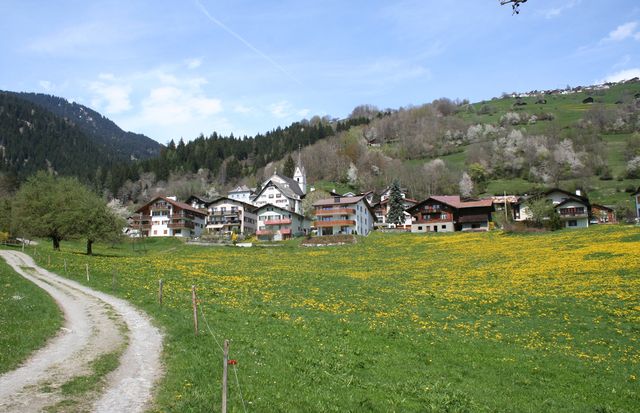
Кастриш (Castrisch, Castrisch)

 Hiking in Кастриш
Castrisch is a small village in the Surselva region of Switzerland, known for its beautiful landscapes and access to various hiking trails. Here are some key points to consider if you're planning a hiking trip in and around Castrisch:
Hiking Trails
-
Diverse Terrain: The region offers a mix of easy to challenging trails that can take you through valleys, mountains, and forests. This makes it suitable for hikers of all levels.
-
Rhaetian Railway Trail: This trail runs alongside the Rhaetian Railway and provides a unique perspective on the landscape, making it great for both hiking and photography.
-
Panoramic Views: Many trails lead to vantage points offering stunning views of the surrounding mountains and valleys, especially during clear weather.
-
Historical Routes: Some trails explore historical paths and local culture, giving hikers a glimpse into the region's heritage.
Best Times to Hike
- Summer (June to September): This is the prime hiking season in the area when the weather is generally warm and dry.
- Autumn (September to October): Ideal for experiencing fall colors and fewer crowds.
- Winter (December to March): Although hiking is possible, it’s advisable to check trail conditions, as snowfall can make hiking challenging.
Practical Tips
- Local Maps: Always carry a local map or download hiking apps with offline capabilities to navigate the trails effectively.
- Weather Preparation: Be prepared for sudden weather changes; layers are key in the mountains.
- Respect Nature: As with all outdoor activities, stay on marked trails, take your trash with you, and respect wildlife.
Amenities
Castrisch itself is a small village with limited facilities, so consider stocking up on supplies before heading out. Nearby larger towns in the region offer more amenities such as restaurants and accommodations.
Conclusion
Hiking around Castrisch offers an excellent opportunity to explore the stunning Swiss landscape, experience local culture, and enjoy the tranquility of nature. Whether you're an experienced hiker or just starting out, the area has something to offer everyone. Always ensure safety by planning ahead, checking the weather, and staying informed about trail conditions.
- Страна:

- Почтовый код: 7126
- Телефонный код: 081
- Код автомобильного номера: GR
- Координаты: 46° 45' 59" N, 9° 13' 0" E


- GPS треки (wikiloc): [Ссылка]
- Высота над уровнем моря: 722 м m
- Площадь: 7.19 кв.км
- Веб сайт: http://www.castrisch.ch
- Википедия русская: wiki(ru)
- Википедия английская: wiki(en)
- Википедия национальная: wiki(de)
- Хранилище Wikidata: Wikidata: Q65656
- Катеория в википедии: [Ссылка]
- код Freebase: [/m/026g3hq]
- код GeoNames: Альт: [8533659]
- ID отношения в OpenStreetMap: [1684059]
- идентификатор HDS: [1434]
- код швейцарского муниципалитета: [3571]
Граничит с регионами:


Иланц
Hiking in Иланц
Ilanz, located in the beautiful Surselva region of the Swiss canton of Graubünden, offers a range of stunning hiking opportunities. Known as the "Gateway to the Rhine Canyon," Ilanz serves as a great base for exploring the surrounding natural landscapes. Here are some highlights and tips for hiking in the Ilanz area:...
- Страна:
- Почтовый код: 7130
- Телефонный код: 081
- Координаты: 46° 45' 59" N, 9° 12' 0" E
- GPS треки (wikiloc): [Ссылка]
- Высота над уровнем моря: 702 м m
- Площадь: 4.67 кв.км
- Веб сайт: [Ссылка]

Шлуайн
Hiking in Шлуайн
Schluein is a picturesque village in the Graubünden region of Switzerland, nestled in the scenic Surselva area. It offers a variety of hiking opportunities, with stunning landscapes that include lush valleys, rugged mountains, and serene rivers....
- Страна:
- Почтовый код: 7151
- Телефонный код: 081
- Код автомобильного номера: GR
- Координаты: 46° 46' 59" N, 9° 13' 59" E
- GPS треки (wikiloc): [Ссылка]
- Высота над уровнем моря: 762 м m
- Площадь: 4.79 кв.км
- Население: 623
- Веб сайт: [Ссылка]


Риайн
Hiking in Риайн
Riein, located in the Aosta Valley region of Italy, is a picturesque area that offers a variety of hiking opportunities. The region is characterized by its stunning alpine scenery, charming villages, and rich natural diversity. Here are some highlights and tips for hiking in and around Riein:...
- Страна:
- Почтовый код: 7128
- Телефонный код: 081
- Код автомобильного номера: GR
- Координаты: 46° 43' 59" N, 9° 13' 0" E
- GPS треки (wikiloc): [Ссылка]
- Высота над уровнем моря: 1270 м m
- Площадь: 15.88 кв.км


Сагонь
Hiking in Сагонь
Sagogn is a charming village located in the Swiss canton of Graubünden, nestled amid stunning alpine scenery. It's an excellent destination for hiking enthusiasts, offering a variety of trails suitable for different skill levels. Here are some key points to consider when hiking in and around Sagogn:...
- Страна:
- Почтовый код: 7152
- Телефонный код: 081
- Код автомобильного номера: GR
- Координаты: 46° 47' 32" N, 9° 15' 21" E
- GPS треки (wikiloc): [Ссылка]
- Высота над уровнем моря: 809 м m
- Площадь: 6.92 кв.км
- Население: 686
- Веб сайт: [Ссылка]


Севгайн
Hiking in Севгайн
Sevgein is a charming village located in the Canton of Graubünden in Switzerland, nestled in a picturesque alpine landscape. Hiking in this area is quite rewarding, combining stunning views, varied terrain, and the opportunity to experience Swiss nature and culture....
- Страна:
- Почтовый код: 7127
- Телефонный код: 081
- Код автомобильного номера: GR
- Координаты: 46° 44' 59" N, 9° 13' 0" E
- GPS треки (wikiloc): [Ссылка]
- Высота над уровнем моря: 861 м m
- Площадь: 4.55 кв.км