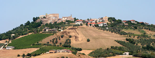
Катиньано (Catignano, Catignano)
.svg)
- коммуна Италии
 Hiking in Катиньано
Catignano is a charming town in the Abruzzo region of Italy, surrounded by beautiful landscapes and offering various hiking opportunities. When hiking in and around Catignano, you're likely to encounter a blend of natural beauty, historical sites, and local culture. Here are some highlights and tips for hiking in the area:
Hiking Trails
-
Local Nature Trails: There are several marked trails in the vicinity of Catignano, ranging from easy to moderate difficulty levels. These trails often pass through lush forests, rolling hills, and offer scenic views of the surrounding countryside.
-
Gran Sasso National Park: A bit further afield, Gran Sasso National Park provides excellent hiking options. With its dramatic peaks, deep valleys, and diverse flora and fauna, it caters to both novice hikers and experienced trekkers. Popular trails include those leading to Corno Grande, the highest peak in the Apennines.
-
Historical Paths: Incorporating historical sightseeing into your hike can be rewarding. Some trails may lead to ancient ruins or charming villages, allowing you to experience local culture and history.
Tips for Hiking in Catignano
-
Weather: Check the weather conditions before heading out, as they can change rapidly, especially in mountainous areas. Spring and early autumn are generally the best seasons for hiking, with mild temperatures.
-
Footwear: Wear appropriate hiking boots for good support and traction. The terrain can be rocky and uneven in places.
-
Supplies: Carry sufficient water, snacks, and a basic first-aid kit. A map or GPS device can be helpful, especially on less-traveled trails.
-
Local Guides: Consider hiring a local guide if you're unfamiliar with the area. They can provide valuable insights into the landscape and hidden gems.
-
Leave No Trace: Adhere to the "Leave No Trace" principles to preserve the natural beauty of the area and minimize your impact on the environment.
Cultural Considerations
Hiking in Catignano can also be an opportunity to engage with the local culture. You may come across small farms, vineyards, and traditional Italian villages. Don't hesitate to interact with locals, as they can offer great recommendations for additional trails and local cuisine to enjoy post-hike.
Overall, hiking in Catignano and its surroundings is a wonderful way to experience the natural beauty and culture of this stunning region of Italy.
- Страна:

- Почтовый код: 65011
- Телефонный код: 085
- Код автомобильного номера: PE
- Координаты: 42° 20' 49" N, 13° 57' 7" E


- GPS треки (wikiloc): [Ссылка]
- Высота над уровнем моря: 365 м m
- Площадь: 17.03 кв.км
- Население: 1337
- Веб сайт: http://www.comune.catignano.pe.it/
- Википедия русская: wiki(ru)
- Википедия английская: wiki(en)
- Википедия национальная: wiki(it)
- Хранилище Wikidata: Wikidata: Q51352
- Катеория в википедии: [Ссылка]
- код Freebase: [/m/0fg8j2]
- код GeoNames: Альт: [6538863]
- код BNF: [150829296]
- код VIAF: Альт: [153810365]
- ID отношения в OpenStreetMap: [41966]
- код ISTAT: 068010
- кадастровый код Италии: C354
Граничит с регионами:
Чивитакуана
- коммуна Италии
Hiking in Чивитакуана
Civitaquana, located in the Abruzzo region of Italy, offers an array of hiking opportunities for outdoor enthusiasts. Nestled in the Apennine Mountains, this charming village is surrounded by scenic landscapes, making it a fantastic destination for nature lovers. Here are some aspects to consider when hiking in Civitaquana:...
- Страна:
- Почтовый код: 65010
- Телефонный код: 085
- Код автомобильного номера: PE
- Координаты: 42° 20' 0" N, 13° 54' 0" E
- GPS треки (wikiloc): [Ссылка]
- Высота над уровнем моря: 550 м m
- Площадь: 21.88 кв.км
- Население: 1225
- Веб сайт: [Ссылка]


Куньоли
- коммуна Италии
Hiking in Куньоли
Cugnoli is a charming village located in the Abruzzo region of Italy, nestled in the picturesque Gran Sasso e Monti della Laga National Park. The region is known for its stunning landscapes, rich biodiversity, and well-marked hiking trails that cater to various skill levels. Here’s an overview of hiking in and around Cugnoli:...
- Страна:
- Почтовый код: 65020
- Телефонный код: 085
- Код автомобильного номера: PE
- Координаты: 42° 18' 30" N, 13° 55' 59" E
- GPS треки (wikiloc): [Ссылка]
- Высота над уровнем моря: 331 м m
- Площадь: 15.96 кв.км
- Население: 1466
- Веб сайт: [Ссылка]


Лорето-Апрутино
- коммуна Италии
Hiking in Лорето-Апрутино
Loreto Aprutino is a charming town located in the Abruzzo region of Italy, known for its stunning landscapes, rolling hills, and proximity to both the mountains and the Adriatic coast. This area offers a variety of hiking opportunities suitable for different skill levels, all set against a backdrop of beautiful natural scenery and historical sites....
- Страна:
- Почтовый код: 65014
- Телефонный код: 085
- Код автомобильного номера: PE
- Координаты: 42° 26' 5" N, 13° 59' 1" E
- GPS треки (wikiloc): [Ссылка]
- Высота над уровнем моря: 307 м m
- Площадь: 59.5 кв.км
- Население: 7369
- Веб сайт: [Ссылка]

Ночиано
- коммуна Италии
Hiking in Ночиано
Nocciano, a charming town in the Abruzzo region of Italy, offers a variety of opportunities for hiking enthusiasts. The surrounding countryside is characterized by rolling hills, vineyards, and scenic views of the Majella and Gran Sasso mountain ranges, making it an excellent destination for outdoor activities....
- Страна:
- Почтовый код: 65010
- Телефонный код: 085
- Код автомобильного номера: PE
- Координаты: 42° 20' 0" N, 13° 59' 0" E
- GPS треки (wikiloc): [Ссылка]
- Высота над уровнем моря: 301 м m
- Площадь: 13.76 кв.км
- Население: 1796
- Веб сайт: [Ссылка]


Пьанелла
- коммуна Италии
Hiking in Пьанелла
Pianella, located in the province of Pescara in Italy, is surrounded by beautiful landscapes and offers several hiking opportunities. The region is characterized by its rolling hills, vineyards, and stunning views of the Adriatic Sea and the Apennine Mountains. Here are some considerations and recommendations for hiking in the area:...
- Страна:
- Почтовый код: 65019
- Телефонный код: 085
- Код автомобильного номера: PE
- Координаты: 42° 23' 57" N, 14° 2' 52" E
- GPS треки (wikiloc): [Ссылка]
- Высота над уровнем моря: 236 м m
- Площадь: 47.05 кв.км
- Население: 8652
- Веб сайт: [Ссылка]