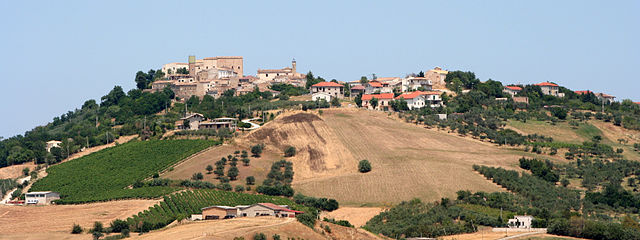
Куньоли (Cugnoli, Cugnoli)
.svg)
- коммуна Италии
 Hiking in Куньоли
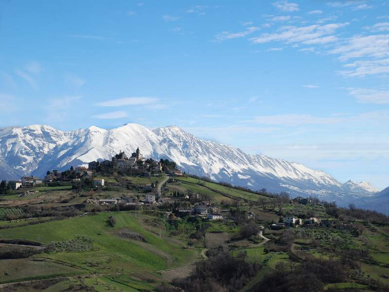
Cugnoli is a charming village located in the Abruzzo region of Italy, nestled in the picturesque Gran Sasso e Monti della Laga National Park. The region is known for its stunning landscapes, rich biodiversity, and well-marked hiking trails that cater to various skill levels. Here’s an overview of hiking in and around Cugnoli:
Trail Options
- Local Nature Trails: Cugnoli has several local trails that allow hikers to explore the beautiful countryside, including vineyards, olive groves, and scenic views of the surrounding hills.
- Gran Sasso National Park Trails: Just a short drive from Cugnoli, the national park offers a plethora of hiking opportunities, including paths that range from easy strolls to challenging hikes. Some popular trails within the park include the ascent to Corno Grande, the highest peak in the Apennines.
- Historical Trails: You can also find trails that connect historical sites, such as ancient churches and ruins, offering both a cultural and natural experience.
Difficulty Levels
- Beginner: There are flat, well-marked trails suitable for families and novice hikers.
- Intermediate: Moderate trails with some elevation gain, providing a bit of challenge while remaining manageable.
- Advanced: Steeper, rugged paths that can lead to breathtaking views but require adequate preparation and experience.
Best Time to Hike
The best time for hiking in the Cugnoli area generally falls between late spring (May-June) and early autumn (September-October) when the weather is mild, and the flora is in full bloom.
Preparation
- Gear: Wear sturdy hiking boots and bring layers of clothing as temperatures can vary. A map or GPS device is also recommended for navigation.
- Hydration: Carry enough water, especially on warmer days, and snacks for energy.
- Local Guidance: Consider local guided hiking tours to enhance your experience, as local guides can provide insights about the environment and history.
Wildlife and Ecology
Abruzzo is known for its rich fauna, including various species of birds, mammals, and unique plant life, so keep an eye out while hiking. Respect the natural environment, stick to marked trails, and follow Leave No Trace principles to preserve the beauty of the area.
Overall, hiking in Cugnoli is a fantastic way to immerse yourself in the natural beauty and culture of this beautiful Italian region. Whether you are looking for a peaceful walk in nature or an adventurous climb, Cugnoli and its surroundings have something to offer for every hiking enthusiast.
- Страна:

- Почтовый код: 65020
- Телефонный код: 085
- Код автомобильного номера: PE
- Координаты: 42° 18' 30" N, 13° 55' 59" E


- GPS треки (wikiloc): [Ссылка]
- Высота над уровнем моря: 331 м m
- Площадь: 15.96 кв.км
- Население: 1466
- Веб сайт: http://www.comune.cugnoli.pe.it/
- Википедия русская: wiki(ru)
- Википедия английская: wiki(en)
- Википедия национальная: wiki(it)
- Хранилище Wikidata: Wikidata: Q51361
- Галерея изображений в википедии: [Ссылка]
- Катеория в википедии: [Ссылка]
- код Freebase: [/m/0fg8n7]
- код GeoNames: Альт: [6538865]
- код VIAF: Альт: [246304900]
- ID отношения в OpenStreetMap: [41954]
- UN/LOCODE: [ITPCU]
- код ISTAT: 068017
- кадастровый код Италии: D201
Граничит с регионами:


Аланно
- коммуна Италии
Hiking in Аланно
Alanno is a charming town located in the province of Pescara, in the Abruzzo region of Italy. It's surrounded by beautiful landscapes, making it a great destination for hiking enthusiasts. Here are some key points about hiking in and around Alanno:...
- Страна:
- Почтовый код: 65020
- Телефонный код: 085
- Код автомобильного номера: PE
- Координаты: 42° 18' 0" N, 13° 58' 0" E
- GPS треки (wikiloc): [Ссылка]
- Высота над уровнем моря: 307 м m
- Площадь: 32.53 кв.км
- Население: 3466
- Веб сайт: [Ссылка]


Катиньано
- коммуна Италии
Hiking in Катиньано
Catignano is a charming town in the Abruzzo region of Italy, surrounded by beautiful landscapes and offering various hiking opportunities. When hiking in and around Catignano, you're likely to encounter a blend of natural beauty, historical sites, and local culture. Here are some highlights and tips for hiking in the area:...
- Страна:
- Почтовый код: 65011
- Телефонный код: 085
- Код автомобильного номера: PE
- Координаты: 42° 20' 49" N, 13° 57' 7" E
- GPS треки (wikiloc): [Ссылка]
- Высота над уровнем моря: 365 м m
- Площадь: 17.03 кв.км
- Население: 1337
- Веб сайт: [Ссылка]
Чивитакуана
- коммуна Италии
Hiking in Чивитакуана
Civitaquana, located in the Abruzzo region of Italy, offers an array of hiking opportunities for outdoor enthusiasts. Nestled in the Apennine Mountains, this charming village is surrounded by scenic landscapes, making it a fantastic destination for nature lovers. Here are some aspects to consider when hiking in Civitaquana:...
- Страна:
- Почтовый код: 65010
- Телефонный код: 085
- Код автомобильного номера: PE
- Координаты: 42° 20' 0" N, 13° 54' 0" E
- GPS треки (wikiloc): [Ссылка]
- Высота над уровнем моря: 550 м m
- Площадь: 21.88 кв.км
- Население: 1225
- Веб сайт: [Ссылка]

Ночиано
- коммуна Италии
Hiking in Ночиано
Nocciano, a charming town in the Abruzzo region of Italy, offers a variety of opportunities for hiking enthusiasts. The surrounding countryside is characterized by rolling hills, vineyards, and scenic views of the Majella and Gran Sasso mountain ranges, making it an excellent destination for outdoor activities....
- Страна:
- Почтовый код: 65010
- Телефонный код: 085
- Код автомобильного номера: PE
- Координаты: 42° 20' 0" N, 13° 59' 0" E
- GPS треки (wikiloc): [Ссылка]
- Высота над уровнем моря: 301 м m
- Площадь: 13.76 кв.км
- Население: 1796
- Веб сайт: [Ссылка]

Пьетранико
- коммуна Италии
Hiking in Пьетранико
Pietranico is a small village located in the Abruzzo region of Italy, surrounded by stunning natural landscapes that are perfect for hiking enthusiasts. Nestled in the foothills of the Gran Sasso mountain range, Pietranico offers a variety of trails suitable for different skill levels, from leisurely walks to more challenging hikes....
- Страна:
- Почтовый код: 65020
- Телефонный код: 085
- Код автомобильного номера: PE
- Координаты: 42° 17' 0" N, 13° 55' 0" E
- GPS треки (wikiloc): [Ссылка]
- Высота над уровнем моря: 590 м m
- Площадь: 14.77 кв.км
- Население: 477
- Веб сайт: [Ссылка]