Чедеголо (Cedegolo, Cedegolo)
.svg)
- коммуна Италии
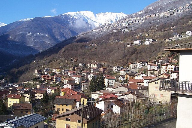
 Hiking in Чедеголо
Cedegolo, located in the Lombardy region of Italy, offers beautiful hiking opportunities primarily situated within the scenic boundaries of the Adamello Regional Park. The area is known for its stunning landscapes, diverse flora and fauna, and a rich network of trails suited for various skill levels. Here are some highlights of hiking in Cedegolo:
Trail Options:
-
Sentiero dei Fiori: This trail is known for its stunning views of the surrounding mountains and valleys. It is generally considered moderate in difficulty and can be enjoyed by families and experienced hikers alike.
-
Val di Cedegolo: The valley offers several paths that lead deeper into the Adamello mountains. Hikes in this area often feature picturesque alpine scenery, waterfalls, and unique geological formations.
-
Cima di Lago: For more experienced hikers, this trail leads to higher altitudes and provides breathtaking panoramic views. The ascent may be steep, but the rewards are well worth the effort.
Nature and Scenery:
Hiking in Cedegolo provides the chance to experience diverse ecosystems, from lush meadows to rugged mountain terrain. The flora varies throughout the seasons, with wildflowers blooming in spring and vibrant foliage in the fall. Wildlife such as chamois, deer, and various bird species can often be spotted.
Practical Considerations:
- Season: The best time for hiking in this region is typically from late spring to early fall, as snow can limit access to higher trails in winter.
- Gear: Sturdy hiking boots are essential, along with weather-appropriate clothing. Also, consider bringing trekking poles, especially for steep or uneven trails.
- Safety: Always inform someone of your hiking plans and check local weather conditions before setting out. Carry enough water and snacks to stay hydrated and energized during your hike.
Accessibility:
Cedegolo is accessible from nearby towns, and many visitors combine hiking with exploring local culture, cuisine, and history. Consider visiting local shops or restaurants to enjoy authentic Lombard dishes after your hike.
Overall, hiking in Cedegolo presents a perfect blend of nature, adventure, and cultural experiences, making it an excellent destination for outdoor enthusiasts.
- Страна:

- Почтовый код: 25051
- Телефонный код: 0364
- Код автомобильного номера: BS
- Координаты: 46° 4' 39" N, 10° 21' 2" E


- GPS треки (wikiloc): [Ссылка]
- Высота над уровнем моря: 413 м m
- Площадь: 11.08 кв.км
- Население: 1173
- Веб сайт: http://www.comune.cedegolo.bs.it
- Википедия русская: wiki(ru)
- Википедия английская: wiki(en)
- Википедия национальная: wiki(it)
- Хранилище Wikidata: Wikidata: Q103874
- Галерея изображений в википедии: [Ссылка]
- Катеория в википедии: [Ссылка]
- код Freebase: [/m/041vzz]
- код GeoNames: Альт: [6536553]
- код VIAF: Альт: [234807742]
- ID отношения в OpenStreetMap: [46768]
- код TGN: [1044127]
- код ISTAT: 017047
- кадастровый код Италии: C417
Граничит с регионами:
Берцо-Демо
- коммуна Италии
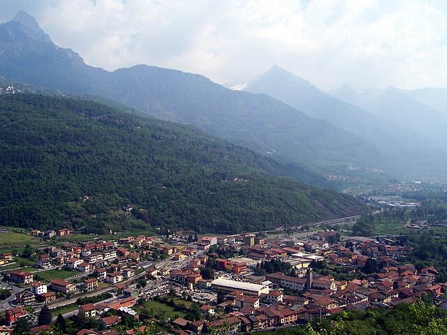
Hiking in Берцо-Демо
Berzo Demo is a charming village located in the province of Brescia in northern Italy, nestled in the Trentini mountains. It's a great spot for those interested in hiking, as it offers a mix of scenic trails and natural beauty. Here are some points to consider when hiking in and around Berzo Demo:...
- Страна:
- Почтовый код: 25040
- Телефонный код: 0364
- Код автомобильного номера: BS
- Координаты: 46° 5' 38" N, 10° 20' 4" E
- GPS треки (wikiloc): [Ссылка]
- Высота над уровнем моря: 785 м m
- Площадь: 15.46 кв.км
- Население: 1638
- Веб сайт: [Ссылка]
Капо-ди-Понте
- коммуна Италии
Hiking in Капо-ди-Понте
Capo di Ponte, located in the province of Brescia in the Lombardy region of northern Italy, is known for its stunning landscapes and rich cultural heritage. The area is part of the larger Adamello Regional Park, which offers a variety of hiking trails suitable for all levels of hikers....
- Страна:
- Почтовый код: 25044
- Телефонный код: 0364
- Код автомобильного номера: BS
- Координаты: 46° 1' 54" N, 10° 20' 46" E
- GPS треки (wikiloc): [Ссылка]
- Высота над уровнем моря: 362 м m
- Площадь: 18.11 кв.км
- Население: 2471
- Веб сайт: [Ссылка]

Чево
- коммуна Италии
Hiking in Чево
Cevo is a charming village located in the Valtellina region of northern Italy, known for its breathtaking landscapes, lush nature, and a variety of hiking opportunities. Here are some key points to consider if you're planning a hiking trip in and around Cevo:...
- Страна:
- Почтовый код: 25040
- Телефонный код: 0364
- Код автомобильного номера: BS
- Координаты: 46° 4' 51" N, 10° 22' 10" E
- GPS треки (wikiloc): [Ссылка]
- Высота над уровнем моря: 1100 м m
- Площадь: 35.47 кв.км
- Население: 865
- Веб сайт: [Ссылка]

Чимберго
- коммуна Италии
Hiking in Чимберго
Cimbergo, located in the Lombardy region of Italy, is known for its beautiful landscapes and historical significance, which make it an attractive destination for hikers and outdoor enthusiasts. Here are some key points about hiking in Cimbergo:...
- Страна:
- Почтовый код: 25050
- Телефонный код: 0364
- Код автомобильного номера: BS
- Координаты: 46° 1' 30" N, 10° 22' 0" E
- GPS треки (wikiloc): [Ссылка]
- Высота над уровнем моря: 850 м m
- Площадь: 24.71 кв.км
- Население: 539
- Веб сайт: [Ссылка]

Паспардо
- коммуна Италии
Hiking in Паспардо
Paspardo is a charming village located in the Val Camonica region of northern Italy, known for its beautiful landscapes and opportunities for hiking. The surrounding mountains and valleys offer various trails for hikers of all skill levels. Here are some key points to consider when hiking in the Paspardo area:...
- Страна:
- Почтовый код: 25050
- Телефонный код: 0364
- Код автомобильного номера: BS
- Координаты: 46° 1' 54" N, 10° 22' 19" E
- GPS треки (wikiloc): [Ссылка]
- Высота над уровнем моря: 978 м m
- Площадь: 11.15 кв.км
- Население: 600
- Веб сайт: [Ссылка]

Селлеро
- коммуна Италии
Hiking in Селлеро
Sellero is a picturesque village located in the Lombardy region of Italy, nestled among the Tuscan-Emilian Apennines. It's an excellent destination for outdoor enthusiasts who enjoy hiking and exploring nature....
- Страна:
- Почтовый код: 25050
- Телефонный код: 0364
- Код автомобильного номера: BS
- Координаты: 46° 3' 21" N, 10° 20' 52" E
- GPS треки (wikiloc): [Ссылка]
- Высота над уровнем моря: 376 м m
- Площадь: 14.47 кв.км
- Население: 1441
- Веб сайт: [Ссылка]