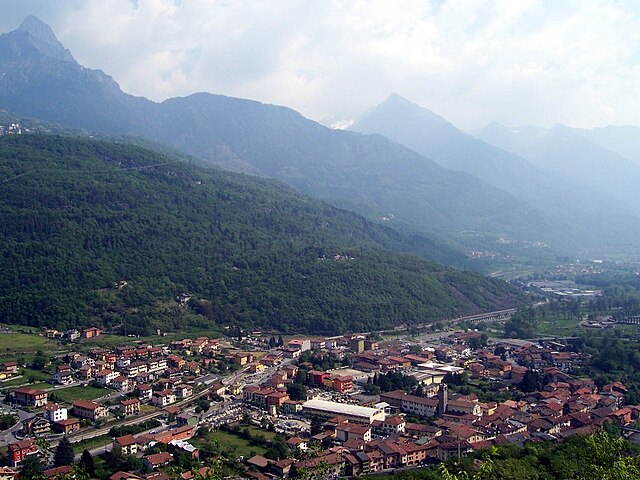
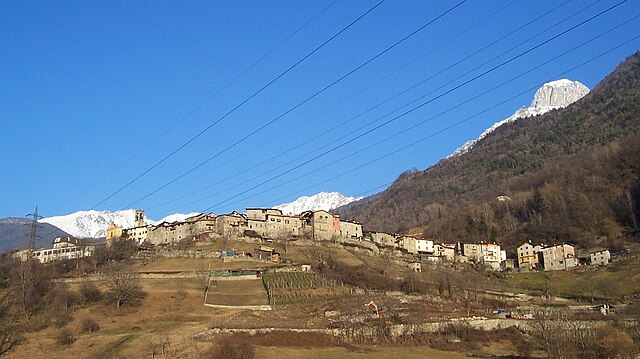
Чимберго (Cimbergo, Cimbergo)
.svg)
- коммуна Италии
 Hiking in Чимберго
Cimbergo, located in the Lombardy region of Italy, is known for its beautiful landscapes and historical significance, which make it an attractive destination for hikers and outdoor enthusiasts. Here are some key points about hiking in Cimbergo:
Scenic Trails
- Natural Landscapes: The area offers a range of trails that take you through lush forests, rolling hills, and picturesque views of the surrounding mountains.
- Varied Terrain: Hikes in Cimbergo can range from easy walks suitable for families to more challenging trails for experienced hikers, providing options for all skill levels.
Historical Significance
- Rock Engravings: Cimbergo is famous for its rock engravings dating back to the prehistoric period, particularly in the nearby area of Valcamonica. Hiking in this region allows you to experience both nature and archaeology.
Popular Hiking Routes
- Valle Camonica Trails: Numerous trails intersect here, allowing you to explore different parts of the valley, including treks that lead to stunning viewpoints and historical sites.
- Monte Guglielmo: A popular peak in the area offering rewarding views and a network of trails that can be coupled with other routes in the region.
Tips for Hikers
- Proper Gear: Depending on the season, ensure you have the right hiking shoes, clothing, and gear. Weather can be variable, so prepare accordingly.
- Local Information: It’s helpful to have a map or GPS device. Local tourist offices can provide up-to-date trail information and recommendations.
- Respect Nature: Follow Leave No Trace principles to maintain the natural beauty of the area for future visitors.
Best Time to Visit
- Spring and Autumn: These seasons usually offer milder weather, fewer tourists, and vibrant natural scenery with blooming flowers in spring and colorful foliage in autumn.
Cimbergo can be a delightful destination for hiking, combining natural beauty and cultural heritage, making it perfect for both avid trekkers and casual walkers. Always remember to check local conditions and trail maps before heading out to ensure a safe and enjoyable hike!
- Страна:

- Почтовый код: 25050
- Телефонный код: 0364
- Код автомобильного номера: BS
- Координаты: 46° 1' 30" N, 10° 22' 0" E


- GPS треки (wikiloc): [Ссылка]
- Высота над уровнем моря: 850 м m
- Площадь: 24.71 кв.км
- Население: 539
- Веб сайт: http://www.comune.cimbergo.bs.it/
- Википедия русская: wiki(ru)
- Википедия английская: wiki(en)
- Википедия национальная: wiki(it)
- Хранилище Wikidata: Wikidata: Q104014
- Галерея изображений в википедии: [Ссылка]
- Катеория в википедии: [Ссылка]
- код Freebase: [/m/041w5y]
- код GeoNames: Альт: [6540607]
- код VIAF: Альт: [247429532]
- ID отношения в OpenStreetMap: [46742]
- WOEID: [714097]
- код ISTAT: 017054
- кадастровый код Италии: C691
Граничит с регионами:
Капо-ди-Понте
- коммуна Италии
Hiking in Капо-ди-Понте
Capo di Ponte, located in the province of Brescia in the Lombardy region of northern Italy, is known for its stunning landscapes and rich cultural heritage. The area is part of the larger Adamello Regional Park, which offers a variety of hiking trails suitable for all levels of hikers....
- Страна:
- Почтовый код: 25044
- Телефонный код: 0364
- Код автомобильного номера: BS
- Координаты: 46° 1' 54" N, 10° 20' 46" E
- GPS треки (wikiloc): [Ссылка]
- Высота над уровнем моря: 362 м m
- Площадь: 18.11 кв.км
- Население: 2471
- Веб сайт: [Ссылка]

Чедеголо
- коммуна Италии
Hiking in Чедеголо
Cedegolo, located in the Lombardy region of Italy, offers beautiful hiking opportunities primarily situated within the scenic boundaries of the Adamello Regional Park. The area is known for its stunning landscapes, diverse flora and fauna, and a rich network of trails suited for various skill levels. Here are some highlights of hiking in Cedegolo:...
- Страна:
- Почтовый код: 25051
- Телефонный код: 0364
- Код автомобильного номера: BS
- Координаты: 46° 4' 39" N, 10° 21' 2" E
- GPS треки (wikiloc): [Ссылка]
- Высота над уровнем моря: 413 м m
- Площадь: 11.08 кв.км
- Население: 1173
- Веб сайт: [Ссылка]
Чето
- коммуна Италии
Hiking in Чето
Ceto, located in the northern Italian region of Lombardy, is a hidden gem for hiking enthusiasts. Nestled in the Val Camonica, this area is known for its stunning landscapes, rich natural beauty, and historical significance. Here are some highlights and tips for hiking in Ceto:...
- Страна:
- Почтовый код: 25040
- Телефонный код: 0364
- Код автомобильного номера: BS
- Координаты: 46° 0' 12" N, 10° 21' 10" E
- GPS треки (wikiloc): [Ссылка]
- Высота над уровнем моря: 453 м m
- Площадь: 32.3 кв.км
- Население: 1886
- Веб сайт: [Ссылка]

Чево
- коммуна Италии
Hiking in Чево
Cevo is a charming village located in the Valtellina region of northern Italy, known for its breathtaking landscapes, lush nature, and a variety of hiking opportunities. Here are some key points to consider if you're planning a hiking trip in and around Cevo:...
- Страна:
- Почтовый код: 25040
- Телефонный код: 0364
- Код автомобильного номера: BS
- Координаты: 46° 4' 51" N, 10° 22' 10" E
- GPS треки (wikiloc): [Ссылка]
- Высота над уровнем моря: 1100 м m
- Площадь: 35.47 кв.км
- Население: 865
- Веб сайт: [Ссылка]

Паспардо
- коммуна Италии
Hiking in Паспардо
Paspardo is a charming village located in the Val Camonica region of northern Italy, known for its beautiful landscapes and opportunities for hiking. The surrounding mountains and valleys offer various trails for hikers of all skill levels. Here are some key points to consider when hiking in the Paspardo area:...
- Страна:
- Почтовый код: 25050
- Телефонный код: 0364
- Код автомобильного номера: BS
- Координаты: 46° 1' 54" N, 10° 22' 19" E
- GPS треки (wikiloc): [Ссылка]
- Высота над уровнем моря: 978 м m
- Площадь: 11.15 кв.км
- Население: 600
- Веб сайт: [Ссылка]