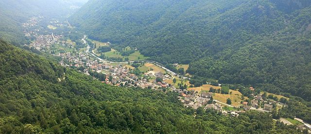
Черес (Ceres, Ceres)
- коммуна Италии
 Hiking in Черес
Ceres, located in the Piedmont region of Italy, offers some beautiful hiking opportunities amidst its scenic landscapes, lush forests, and charming villages. The area is characterized by its rolling hills, alpine scenery, and rich biodiversity, making it a great destination for hikers of all levels.
Hiking Trails in Ceres:
-
Giro delle Creste: This is a popular circular hike that provides stunning panoramic views over the surrounding valleys and mountains. It's ideal for those who enjoy varying terrain and beautiful vistas.
-
Sentiero del Rio Freddo: This trail follows the river and leads through dense woodlands, making it a wonderful choice for those seeking a lush environment. It's relatively easy and family-friendly.
-
Parco Naturale della Val Grande: While this park is a bit farther from Ceres, it is worth mentioning for those looking for more extensive hiking options. The park features a range of trails that vary in difficulty and length, providing experiences for both novice and experienced hikers.
Tips for Hiking in Ceres:
-
Best Time to Hike: Spring and early autumn are ideal for hiking, as the weather is usually mild, and the trails are less crowded.
-
Local Regulations: Always check for any local regulations regarding trail usage and opening times, particularly in protected areas.
-
Gear Up: In addition to the standard hiking gear (good footwear, hydration pack, snacks), consider trekking poles if you're tackling more challenging trails.
-
Wildlife: Be mindful of local wildlife and follow guidelines for safe wildlife encounters.
-
Maps and Guides: Carry a detailed map of the area or consider hiring a local guide if you're unfamiliar with the landscape.
Local Culture and Attractions:
After your hike, you can enjoy the local culture in Ceres, perhaps visiting local restaurants to try Piedmontese cuisine or exploring historical sites in the area. Piedmont is famous for its truffles, wines (like Barolo), and rich culinary heritage, so don't miss the opportunity to indulge in local delicacies.
Conclusion:
Hiking in Ceres, Piedmont, combines the thrill of outdoor adventure with the beauty of Italian nature and culture. Whether you're a seasoned hiker or a casual walker, the region offers a variety of experiences that showcase the simplicity and beauty of the great outdoors. Remember to prepare adequately and enjoy your time exploring the stunning landscapes!
- Страна:

- Почтовый код: 10070
- Телефонный код: 0123
- Код автомобильного номера: TO
- Координаты: 45° 18' 47" N, 7° 23' 19" E


- GPS треки (wikiloc): [Ссылка]
- Высота над уровнем моря: 704 м m
- Площадь: 28.05 кв.км
- Население: 1036
- Веб сайт: http://www.comune.ceres.to.it
- Википедия русская: wiki(ru)
- Википедия английская: wiki(en)
- Википедия национальная: wiki(it)
- Хранилище Wikidata: Wikidata: Q9244
- Катеория в википедии: [Ссылка]
- код Freebase: [/m/0g6v8x]
- код GeoNames: Альт: [6537267]
- ID отношения в OpenStreetMap: [44671]
- идентификатор местоположения ArchINFORM: [16452]
- код ISTAT: 001072
- кадастровый код Италии: C497
Граничит с регионами:


Ала-ди-Стура
- коммуна Италии
Hiking in Ала-ди-Стура
Ala di Stura is a picturesque town located in the Piedmont region of Italy, nestled within the beautiful natural scenery of the Alps. It’s known for its stunning landscapes, rich flora and fauna, and numerous trails that cater to hikers of all skill levels....
- Страна:
- Почтовый код: 10070
- Телефонный код: 0123
- Код автомобильного номера: TO
- Координаты: 45° 19' 0" N, 7° 18' 0" E
- GPS треки (wikiloc): [Ссылка]
- Высота над уровнем моря: 1080 м m
- Площадь: 46.33 кв.км
- Население: 456
- Веб сайт: [Ссылка]

Кантойра
- коммуна Италии
Hiking in Кантойра
Cantoira, located in the metropolitan area of Turin in Italy, is a beautiful destination for hiking enthusiasts. Nestled in the Susa Valley, it offers a range of trails that showcase stunning landscapes, lush forests, and panoramic views of the surrounding mountains....
- Страна:
- Почтовый код: 10070
- Телефонный код: 0123
- Код автомобильного номера: TO
- Координаты: 45° 21' 0" N, 7° 23' 0" E
- GPS треки (wikiloc): [Ссылка]
- Высота над уровнем моря: 750 м m
- Площадь: 23.03 кв.км
- Население: 562
- Веб сайт: [Ссылка]


Кьяламберто
- коммуна Италии
Hiking in Кьяламберто
Chialamberto is a small hamlet located in the Susa Valley in the Piedmont region of Italy, known for its stunning natural beauty and rich cultural heritage. It offers a variety of hiking opportunities that appeal to outdoor enthusiasts of all skill levels. Here are some highlights about hiking in and around Chialamberto:...
- Страна:
- Почтовый код: 10070
- Телефонный код: 0123
- Код автомобильного номера: TO
- Координаты: 45° 22' 0" N, 7° 20' 0" E
- GPS треки (wikiloc): [Ссылка]
- Высота над уровнем моря: 875 м m
- Площадь: 35.45 кв.км
- Население: 343
- Веб сайт: [Ссылка]

Меццениле
- коммуна Италии
Hiking in Меццениле
Mezzenile is a picturesque municipality located in the metropolitan city of Turin, northern Italy. Nestled in the Susa Valley, it offers a range of hiking opportunities that highlight the natural beauty of the surrounding Italian Alps....
- Страна:
- Почтовый код: 10070
- Телефонный код: 0123
- Код автомобильного номера: TO
- Координаты: 45° 18' 0" N, 7° 24' 0" E
- GPS треки (wikiloc): [Ссылка]
- Высота над уровнем моря: 654 м m
- Площадь: 29.09 кв.км
- Население: 809
- Веб сайт: [Ссылка]


Монастеро-ди-Ланцо
- коммуна Италии
Hiking in Монастеро-ди-Ланцо
Monastero di Lanzo is a beautiful area located in the Susa Valley of the Piedmont region in Italy, known for its stunning landscapes and rich cultural heritage. The area offers numerous hiking opportunities that cater to various skill levels....
- Страна:
- Почтовый код: 10070
- Телефонный код: 0123
- Код автомобильного номера: TO
- Координаты: 45° 18' 0" N, 7° 26' 0" E
- GPS треки (wikiloc): [Ссылка]
- Высота над уровнем моря: 825 м m
- Площадь: 17.66 кв.км
- Население: 354
- Веб сайт: [Ссылка]


Пессинетто
- коммуна Италии
Hiking in Пессинетто
Pessinetto, located in the Piedmont region of Italy, is a charming area for hiking enthusiasts. Nestled in the Susa Valley, it offers a variety of trails that cater to different skill levels, making it suitable for both beginners and more experienced hikers....
- Страна:
- Почтовый код: 10070
- Телефонный код: 0123
- Код автомобильного номера: TO
- Координаты: 45° 17' 0" N, 7° 24' 0" E
- GPS треки (wikiloc): [Ссылка]
- Высота над уровнем моря: 590 м m
- Площадь: 5.35 кв.км
- Население: 618
- Веб сайт: [Ссылка]